Alaska Highway: Scouting the Route
Have you ever driven the Alcan — or just wished you could? The 1,520-mile road through Canada and Alaska is a magnet for adventurous travelers.
There are some hardships: rough pavement, dust, mud, and long empty stretches between the few settlements supplying food, gas, and a place to stay.
The payoff? Beautiful landscapes, wildlife, and a feeling of freedom. Scout the Alaska Highway's route with two AMERICAN EXPERIENCE producers.
Building the Alaska Highway producers Tracy Heather Strain and Randall MacLowry traveled the highway in July 2003, looking for locations, stories, and images. They returned in March 2004 to shoot footage for the documentary. Take a virtual road trip with Tracy as your guide, and explore the path of the Alcan through British Columbia, the Yukon, and Alaska.
Dawson Creek, British Columbia, Mile 0
I took this picture in the South Peace Historical Society, which is run by Gerry Clare (pictured). The Society holds a vast collection of photographs, newspapers, and other materials regarding the Alaska Highway's construction. The soldiers and civilian contractors who worked on the road donated many of the photos.
We returned in October 2003 to interview British Columbia residents. Gerry Clare helped us in so many ways. We visited the Dawson Creek Station Museum, which is the old train station, and met the daughter of the stationmaster. We started our collection of Alaska Highway gifts and mementos here in the museum's gift shop.
Dawson Creek was chosen to be the start of the Alaska Highway because a train ran from Edmonton, Alberta to Dawson Creek. In 1941, less than 500 people lived there, but in 1942 the population rose to 20,000 with the arrival of soldiers and civilian contractors who moved in to begin the highway and related projects. Thousands of pieces of equipment and supplies also were shipped through the terminus at Dawson Creek.
Just NW of Dawson Creek, British Columbia, Mile 2
Randy and I didn't know if we would be able to keep on our schedule if there was something interesting to check out every two miles. There were 50th anniversary signs stretched out along the highway.
The Canadian Telegraph project, known as CANTEL, was a vital dimension of the Alaska Highway project, enabling the military to communicate along the entire length of the road. This station was just one of many that served to repeat transmitted messages. The telephone/telegraph line stretched from Alberta, Canada to Fairbanks, Alaska when it was finished, and at the time it was one of the world's longest open-wire circuits.
All the things we learned about the Alaska Highway project couldn't make it into the film. For instance, thousands of soldiers and civilians worked on things other than the highway. In addition to CANTEL, thousands worked on CANOL, the vast Canadian oil pipeline project.
Kiskatinaw Provincial Park, British Columbia, Mile 17
The Kiskatinaw River was very low, and it was hard to imagine all of the canoeing that typically goes on there. It was lovely, but we couldn't stay long because we had people to meet in Taylor and Fort St. John.
We were excited to see evidence of the original work completed in 1942, but realized that the soldiers did not build this bridge. Civilian contractors, experienced engineers and construction workers put this in place.
This wooden trestle bridge, which curves nine degrees over its 534-foot length, was the first of its kind in Canada. It is the only original wooden bridge still in use from the Alaska Highway project. Work began in November of 1942.
Fort Nelson, British Columbia, Historic Mile 300
The multi-ton Caterpillar D-8 tractor was key to building the highway. Prior to the arrival of new machines like the D-8, the Army Corps of Engineers did its work by hand and with the help of animals. The Corps in an earlier period was known as a "pick and shovel" brigade.
Marl Brown, who has the most amazing collection of vintage military vehicles, construction equipment, and antique cars, runs the Fort Nelson Heritage Museum. His vehicles work too! The picture shows a wartime D-6 Cat. The museum also has exhibits from the 1800s when Fort Nelson was a fur-trading post. The town is the site of the original Hudson Bay Company store.
The highway goes through Fort Nelson because the Canadian government had planned to put an airport in there to be a part of the Northwest Staging Route. There was no road to get supplies, equipment, and personnel to the airports of the Northwest Staging Route -- which is one reason the highway was deemed vital to the continent's defense. I was attacked by mosquitoes at Fort Nelson and the bites took at least a month to heal. I felt bad for the highway-building soldiers who could not go indoors to get away.
Muncho Lake, British Columbia, Historic Mile 456
Muncho Lake means "big lake" in the Kaska Dene dialect. The lake was a beautiful color, the result of copper oxides leached from the bedrock. To get there we completed a hazardous drive through the Northern Rockies. The road was steep and narrow with no shoulder. Stone sheep would suddenly appear in the middle of the road as we rounded a curve. Rocks were still falling down the mountain. The soldiers had to cut through the rock to create the road, and horse-drawn boats were used to haul the rock away.
Between Watson Lake and Muncho Lake, British Columbia, Near Historic Mile 620, Lower Post
Not much of the original pioneer highway that was punched through in 1942 exists. As early as the next year, the road was shifted here and there, and after the war, the Canadian government moved it significantly throughout. You can see evidence of the moves as you look at the trees along the road. Periodically you see a wide swath of trees that are shorter than others -- the tell-tale signs of the original Alcan.
I tried to imagine what an overwhelmingly difficult job it was to construct this highway. Not just the physical challenge but the psychological challenge of loneliness. Randy and I spent a lot of time talking about where and when we were going to film the modern highway for the documentary. Fall, winter, or spring were on the table.
Watson Lake, Yukon Territory, Historic Mile 635
Marl Brown gave us an old license plate so we would have a sign for Watson Lake. I had been working on our sign since we left Fort Nelson. Fortunately the park had nails and hammers for us to use to put it up. I never thought I'd travel to Yukon Territory, and if I did, I never imagined a scene like this.
A homesick soldier, Carl Lindley of Danville, Illinois, put up an arrow with the name of his hometown that also stated the mileage. Other soldiers followed suit, and the tradition continues today.
Between Whitehorse and Watson Lake, Yukon Territory, Near Historic Mile 706, near Rancheria
There were long stretches during our trip where the scenery looked like this. We decided it was best to show the muskeg in archival footage rather than messing around in the muck with a camera and crew. Muskeg was one of the terrible "m" problems on the highway: muskeg, mosquitoes and mud.
Whitehorse, Yukon Territory, Historic Mile 918
We were happy to reach Whitehorse. During the war, Whitehorse was the site of the northern sector's headquarters. In January 1942 there were about 800 people living here. By April 1942 there were over 40,000.
Today, two-thirds of the people who live in Yukon Territory call Whitehorse home. It was such an international scene. We had excellent coffee at Midnight Sun Coffee Roasters -- but we skipped the musk-ox, caribou and bison at the Klondike Rib & Salmon BBQ.
Randy poses here with highway historian Earl Brown and his son, Perry. Earl's father is Marl Brown, who runs the museum in Fort Nelson. The Brown family helped the production by providing information, contacts, and friendship during the making of the documentary. We couldn't have planned our scouting trip without Earl's detailed work in the most comprehensive bible of the Alaska Highway, The Milepost.
Whitehorse, Yukon Territory, Historic Mile 918
In my hotel room, I stumbled upon a television station that broadcast the comings and goings on the streets of Whitehorse. I sat near the window watching the television for awhile and then I decided to just look out the window instead. We conducted pre-interviews with several people in town, because of the town's relatively close proximity to Vancouver; we knew that we would return to shoot aerials in this region. Whitehorse's earlier claim to fame came during the Klondike Gold Rush.
Outside of Whitehorse, Yukon Territory, [not on the highway]
Locations manager and photographer Rob Toohey took this picture of me with the slate. It was our final day of shooting, and I was so happy. To get the driver's-point-of-view shots in the documentary, we mounted the 16mm camera onto a vehicle using straps and a piece of equipment that was like a mini bean bag chair.
Near Carcross, Yukon Territory, [not on the highway]
Our first day of shooting was exciting. Whitehorse was less crowded in the late winter, but tourists were still making their way to Yukon. Our flight from Vancouver was filled with Swiss heli-skiers on holiday. Stephen McCarthy not only filmed the scenics and aerials for the documentary, but as director of photography he developed the lighting for our videotaped interviews.
North of Haines Junction, Yukon Territory, Mile ?
Haines Junction, at Historic Mile 1016, was established during the construction of the Alaska Highway in 1942-43 as a base camp for soldiers connecting the Alaska Highway with the road to Haines, Alaska.
It was very, very cold this Sunday. We didn't know it at the time, but Randy, Stephen and Trans North's chief pilot Grant Shannon were lifting off to capture what would be the last shot in the documentary.
It took weeks for associate producer Michael Rossi and I to plan the scenic and aerial shooting in Yukon. We completed an incredible amount of paperwork for a few days of actual shooting. We rented the equipment in Vancouver, British Columbia. The Tyler mount for the helicopter was shipped over the day before we arrived so that it could be mounted and ready for us. The morning of the shoot we lifted off in time to capture the sunrise. Unfortunately, we lost the first roll of film when the camera's magazine popped open on touch down and exposed the film to sunlight.
Between Haines Junction and Kluane Lake, Yukon Territory, Mile ?
We couldn't have captured the spectacular beauty of the region surrounding the Alaska Highway without Rob Toohey. He scouted the area in the winter and completed all of the paperwork we needed to be able to shoot there, among other important things.
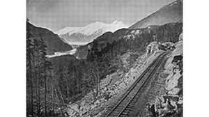
Notice how far the trees are from the road. Over the years, engineers increased the sight lines so that motorists had more time to react to wildlife suddenly running onto the highway. Though this section of the highway is rather hilly, engineers also flattened the highway and reduced grades to make it easier for drivers.
Kluane Lake, Yukon Territory, Historic Mile 1053
Near the ghost town of Silver City Kluane Lake is absolutely stunning. Its name is pronounced CLUE-AH-K NEE. The Southern Tutchone name means 'big whitefish lake.' Forty-six miles long, it is the largest lake in Yukon Territory -- and part of the largest protected area in the world. There were many RVs and trucks on the Alaska Highway. We were told that most of the tourists are Americans; the mystique about driving the Alaska Highway is primarily an American phenomenon. We had been eager to get to Kluane, which is where Soldiers Summit was -- the site of the highway dedication. We scouted the location but decided that the archival footage told the story best.
SE of Delta Junction, Alaska, Mile 1392
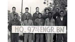
Back in the United States. There were so many interesting bridges and stories, but there wasn't enough time to fit everything into our program. This bridge, built in 1944 by civilians, spans the Gerstle River and is a "steel through truss" design, meaning there is superstructure above the deck. It was dedicated to the African American road builders in 1993.
The only regiment of the U.S. Army Corps of Engineers working in the United States was the 97th Regiment, an outfit of black soldiers and white officers. All of the other regiments completed their work on the highway in Canada. A fourth black regiment working in the north, the 388th, worked on Canol, the oil pipeline project.