A Brief History of the National Weather Service

After a series of weather related disasters sank hundreds of boats on the Great Lakes, President Ulysses S. Grant ordered the army to systematically compile weather observations from stations across the nation. On November 1, 1870, weather forecasts for the eastern United States were being issued for the first time, although these were just 24 hours ahead. Within a few years, the system was expanded to include observations in the Caribbean, thus allowing forecasters to track storms in the Atlantic before they hit the coast. Before the end of the century, the meteorologists were shifted from the Army to the Department of Agriculture as the U.S. Weather Bureau. Later still, the office would become part of the National Oceanic and Atmospheric Administration at the Department of Commerce, where it remains today.
In the beginning, the forecasts of the Weather Bureau were vague, reflecting the state of meteorological science and of the communications network that linked the observation posts. In 1893, for example, a warning was issued of a storm that would hit the East Coast south of New York. When the storm did hit near Savannah, Georgia, more than 2,000 people were killed. Knowledge improved, and by 1915, the Weather Bureau was able to warn the city of New Orleans of a coming storm. The New Orleans Times-Picayune wrote: "Never before, perhaps in the history of the Weather Bureau, have such general warnings been disseminated as were sent out by the local bureau."
Despite the successes, the centralized system located in Washington, D.C., proved to be problematic and not as responsive as many hoped. In 1935, the system was reorganized and local offices were set up in Jacksonville, New Orleans, Boston and San Juan, Puerto Rico. Airplane flights and more extensive communication systems provided better data for the Weather Bureau, and forecasts improved. However, there were still some surprises.
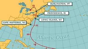
In September of 1938, the meteorologists at the Weather Bureau were tracking a storm from the Cape Verde Islands that bloomed into a hurricane as it moved west across the Atlantic. On the night of the 20th, the hurricane was noted to be east-northeast of Jacksonville. By 7:30 the next morning, the storm was east of Cape Hatteras, North Carolina. Forecasters breathed a sigh of relief as the storm passed toward the north, away from the usual landfall sites.
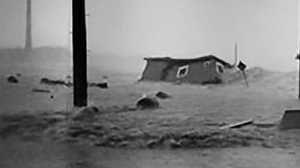
Dr. Charles C. Clark, acting chief of the Weather Bureau at the time, said, "On the basis of the data on hand [the forecasters] could hardly have given any greater advance warning, for the tropical storm — the worst in the history of the Northeast -- was a freak; it did not follow the usual pattern." He was right, insofar as no hurricane had hit New England for over a century, but the meteorological pattern was there for those who could see it.
Charles H. Pierce, a 28-year-old junior forecaster filling in for the day, calculated that a warm front to the east of the storm could push the hurricane onto land. Senior forecasters decided against issuing a warning since they thought that New England was not susceptible to hurricanes.
Once the hurricane hit Long Island, the warnings were superfluous and the meteorologists could only measure and record the storm's path on September 21. The storm's speed — twice as fast as usual — and a sense of complacency in the bureau both contributed to the lack of warning. The forecasters' subsequent excuse was that the public in the Northeastern states would not have understood what a hurricane warning entailed.
Since 1938, advances in radar, satellite imagery and a better understanding of the forces of nature have allowed meteorologists at the National Weather Bureau, now known as the National Weather Service, to forecast storms with increasing accuracy.