The Path of the Hurricane of '38

Before the system of assigning names to hurricanes was initiated during the early 1950s, tropical storms and hurricanes were often named with reference to the year of their occurrence and the area they devastated. Thus the name --The New England Hurricane of 1938 — although some people still refer to this storm as the "Long Island Express," referring to its remarkable forward speed. For those who lived through the storm, it remains the weather event of their lifetimes.
The first signs of the storm can be traced back to a wind shift noted by French observers at Bilma Oasis in the Sahara Desert on September 4th. As this disturbance passed off the West African coast it developed into a tropical storm near the Cape Verde Islands, probably about September 10th. With the storm picking up speed, moving westward across the Atlantic Ocean, a Brazilian freighter, the S.S. Alegrete, encountered the storm at hurricane strength, with winds of 74 mph or faster, on September 16. The Jacksonville office of the U.S. Weather Bureau issued warnings for Florida, which had been impacted twice before in the previous decade by major hurricanes. Reports from ships at sea estimated the wind speeds at 160 mph on September 19, just east of the Bahamas. Floridians were relieved when the storm slowed and began a curve to the north. At this point the storm came abreast of Jacksonville and forecast responsibility was passed to the Washington, D.C., Weather Bureau office. Forecasters assumed that the storm would follow the path other storms had for decades. As an old timers' "Line Storm" — with the sun passing the line of the equator at the fall equinox — it would pass out to sea and brush the coast with some wind.
At 9:00a.m. on Wednesday, September 21, the storm was reported off the coast of Cape Hatteras, North Carolina, and the Cunard liner Carinthia passing close to the Virginia Capes and Cape Hatteras, reported a barometric pressure of 27.85 inches not even passing through the eye of the storm. If forecasters were more historically inclined, they would have recognized that this information suggested that the storm was not heading out to sea as usual, but was moving straight north — as similar hurricanes had in 1635 and 1815. Rain had been falling in the northeastern United States intermittently for days before September 21, representing a trough of low pressure or weakness in the atmosphere. The hurricane responded by moving rapidly in this warm moist pathway. A large high pressure system over the Maritimes of Canada blocked the storm from moving out to sea.
The earth was already saturated from the prior rainfall, with streams and rivers full to their banks across New England. The tide was astronomically high at the autumnal equinox — when both the sun and the moon's gravity tug at the sea level. The stage was set for major impact from all aspects of the storm: wind, rain, and storm surge.
Even the best forecasters, however, would have been hard pressed to forecast the forward speed of this storm. The Hurricane of 1938 swept up the coast to northern latitudes at greater than 60 mph — at least twice as fast as normal. At 1 pm the storm was east of Atlantic City, New Jersey, where part of the Boardwalk was torn up. The eye came ashore at Bayport, Long Island, New York, at 2:30 pm when a barometric pressure was noted at 27.94 inches. When the hurricane and its accompanying tidal surge and surf hit Long Island, the impact registered on seismographs in Alaska.
The eye of the storm was about 50 miles wide at this time, and the storm continued traveling northward into New England at more than 50 mph. The east side of the hurricane — the "dangerous semicircle" — was scouring the countryside at speeds approaching 100 mph with higher gusts estimated at 120 mph on Fishers Island south of New London, Connecticut. In New York City, west of the eye, the top of the Empire State Building recorded winds of 120 mph, although at ground level in Central Park the winds were blowing at 60 mph. With each mile eastward on Long Island the damage worsened. There was nearly total devastation on the beach along Dune Road at Westhampton, where only 26 out of 179 homes stood after the storm and most of those were uninhabitable. The 125-foot steeple atop the Presbyterian Church in Sag Harbor fell, as did hundreds of other steeples that day.
Wind, fire, floodwaters, and tidal surges all caused damage in New England. In New London, Connecticut, the tidal surge drove the five-masted school ship Marsala into a warehouse complex along the docks, setting off a short circuit and fire which consumed a quarter-mile area of the business district -- the worst calamity in New London since Benedict Arnold burned the city in 1781. Firefighters bravely fought the fire in waters up to their necks as the storm surge and fire were driven by strong southerly gales. The fire was only brought under control with the shift of the winds to the northwest.
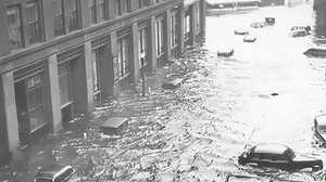
Rhode Island saw the greatest destruction, as wind and tide proved deadly. Along Fort Road in Watch Hill, the beach was swept clean of any signs of habitation. That area of beach has never been rebuilt. Death and destruction occurred along the Rhode Island shore as the storm surge swept across coastal beaches and bays, but the highest water was to be recorded in downtown Providence. Keen observers noted that the morning tide had not fallen since there was a rising southerly gale driving seawater constantly up Narragansett Bay. At about 5 pm the anemometer was blown away at the Providence Weather Bureau office after recording winds to 87 mph. But it was the storm surge, rising as it was funneled up the ever narrowing bay, which was to prove deadly. Just as workers were leaving their offices, the surge hit the downtown business district. In Exchange Place, water which had been just a few inches deep was waist deep within minutes. It rose to a remarkable 13 feet 8-1/2 inches, exceeding the level marked on the Old Market Building after the Hurricane of 1815. Bedsheets were cast out from the second story of the Biltmore Hotel to catch people being swept around the streets in the strong currents. The next day, The Providence Journal headlined 90 deaths across the state, but the destruction was so devastating that it took many days before the true number of deaths -- over 390 -- were fully accounted for.
The Blue Hill Observatory at its 635-foot elevation in Milton, Massachusetts, just south of Boston, recorded a gust of wind out of the south at 186 mph with a sustained wind of 121 mph between 6:11 and 6:16pm. Only one anemometer survived these winds, which remain the second highest winds ever recorded on earth.
The storm traveled almost directly northward up the Connecticut River Valley, dumping copious amounts of rain especially to the westward of its track. Two inches of rain per hour were recorded from the hurricane and over 17 inches of rain fell in places in the four days prior to and including September 21st. River levels in many western New England areas broke the record flood levels just set in the March floods of 1936 — thought by many never to be seen again in their lifetimes. The storm had rapidly undergone transformation to an extratropical low, but still retained tremendous energy, with high winds mowing down forests throughout the north country, knocking down part of Jacob's Ladder, a trestle on the Cog Railway on Mount Washington, New Hampshire, where winds gusted to 163 mph. The storm finally crossed Lake Champlain, near Burlington, Vermont, about 8 pm, destroying apple orchards and maple sugar groves, especially on the hilltops. Even in northern New England there was considerable damage, with soft ground from the rains derailing a Delaware & Hudson train in Castleton, Vermont, and knocking down an elm tree which crashed into the Playhouse Theatre, injuring two people in Montpelier. Flooding was extensive in New Hampshire, causing a major fire in Peterborough. Winds even caused building damage in Maine, well east of the track of the storm.
By 9 pm, the storm moved into Canada. It blew through Montreal and the province of Quebec and eventually expended itself in arctic Canada. Over 690 people lost their lives during the Hurricane of 1938, due in part to the poor forecasts. The rapid forward motion of this storm, however, would make proper warning difficult even with today's technology.
Over $400 million (1938 dollars) in damage was done and the storm took its place among the "Great Hurricanes" in New England's history — along with the storms of 1635 and 1815.


