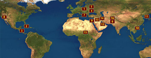
Spy Photos
Surveillance images taken by spy planes and satellites have
been used to sway public opinion ever since President John F. Kennedy
declassified U-2 images of Russian nuclear missiles in Cuba four decades ago.
Since then, the release of such photographs—sometimes officially
sanctioned, sometimes not—has played a crucial role in geopolitics, never
more intensely than in recent years. In this interactive satellite map of the
world, examine a series of influential images released between 1962 and
2005.—Tim Brown

|
|
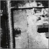
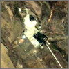
1. Poland,
1944
Disturbing
as they are, aerial images like this one of the Nazi death camp at Auschwitz
had no effect on the camp's operations after they were taken, because the
photos were collected incidentally as part of bomb-strike imagery of the nearby
IG Farben chemical plant. CIA photo interpreters discovered the imagery decades
later. Aerial photos like this one were the precursors to far more
sophisticated satellite imagery to come.
|
|
|
2. Cuba,
1962
During
the Cuban Missile Crisis, President Kennedy declassified this image and others
like it showing construction of medium-range ballistic missile launch sites in
the Cuban countryside. Kennedy used the imagery to generate support for a
military blockade and military strikes against Cuba. Target audiences included
the Soviet leadership and the general public, both domestic and international.
|
|
|
3. Nicaragua,
1982
This
image, taken by an American SR-71 spy plane, shows Soviet merchant ships
unloading military equipment at the Nicaraguan port of Corinto. The U.S. State
Department Office of Public Diplomacy released this image of the Nicaraguan
military buildup to generate support for the "contras" and to
highlight the threat posed by the Soviet Union, Cuba, and Nicaragua of
fomenting revolution throughout Central America.
|
|
|
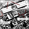
4. Soviet
Union, 1983
The
defense magazine Jane's Defense Weekly
published highly classified satellite imagery of a Soviet aircraft carrier
under construction at the Nikolaev shipyard on
the Black Sea. The images, including this one, were taken by an American KH-11
reconnaissance satellite. Leaked by U.S. naval analyst Samuel Morison, the
images gave the general public around the world a first glance at the
capability of America's classified reconnaissance satellites. The resolution of
this image is about one and a half to three feet per pixel; when the satellite
is directly overhead, it can resolve objects four to six inches in diameter.
|
|
|
5. Soviet
Union, 1986
Imagery
taken by the French satellite SPOT marked the first use of commercial satellite
imagery by a news organization (ABC News) to independently confirm a major news story. This was significant
because the Soviets were denying that the nuclear accident at Chernobyl had
taken place. Satellite imagery, it was now clear, could show events and places
in countries where the news media was denied access. This is a combined
SPOT-Eosat image of Chernobyl; the red dot is a thermal signature revealing the
extreme heat of the reactor meltdown.
|
|
|
6. Afghanistan,
1998
The U.S.
released images from what it called Operation Infinite Reach, including this
image of an Al Qaeda training camp at Zhawar Kili in Afghanistan that was later
bombed. This release, which also included the image of a suspected biological
warfare production plant at Shifa, Sudan, was the first official release of
previously classified satellite imagery by the U.S. government.
|
|
|
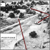
7. Kosovo,
1999
In April
1999, officials of the North Atlantic Treaty Organization, or NATO, released
this pair of aerial photographs taken high above Izbica in western Kosovo,
showing what NATO claimed may be a mass grave containing 150 bodies. NATO
officials cited these photographs as evidence that Serb forces were summarily
executing civilians.
|
|
|
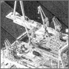
8. United
States, 2000
The
Public Eye project of the Federation of American Scientists ordered this IKONOS
satellite image of the secret U.S. airbase called Area 51—located at
Groom Lake, Nevada—to test the limits of the government's
"shutter-control" policy. Groom Lake is one of America's most sensitive
and closely guarded military flight test centers. After a two-month delay that
included the release of a two-meter Russian image, Space Imaging, which is a
subsidiary of defense contractor Lockheed Martin, finally released the image.
The hangar seen here is configured to allow an aircraft within to taxi or
"drive-thru" with its engines running, out of view of prying
satellite eyes. The horizontal black line at the bottom center of the image is
a blast deflector, which enables the hidden aircraft to run its engines to full
power without damaging nearby buildings or vehicles.
|
|
|
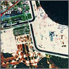
9. Israel,
2000
The
existence of Israel's nuclear program is officially denied by the Israeli
government for fear of mandatory U.S. trade and diplomatic sanctions that would
be imposed if proof of the program were to become public. Israel has not signed
the nuclear nonproliferation treaty, and the U.S. officially turns a blind eye
to Israel's weapons-of-mass-destruction (WMD) program. The release of this
IKONOS image of the Israeli nuclear reactor at Dimona caused some embarrassment
for both Israel and the U.S. The reactor is in the lower left of this image.
|
|
|
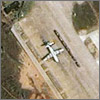
10. China,
2001
After a
Chinese fighter jet collided with a U.S. EP-3 Aries reconnaissance aircraft in
international waters off China, this IKONOS image of the crippled U.S. plane
sitting on the parking ramp of an airbase on China's Hainan Island shortly
after it landed there became an icon for the crisis between the U.S. and China.
(The Chinese pilot ejected from his plane, which then crashed in the ocean, but
he was never found.) The image also demonstrated the ability of commercial
satellite imagery to quickly tell a story in a denied country. The Chinese
government eventually allowed U.S. officials to dismantle and retrieve the
plane using a Russian transport aircraft.
|
|
|
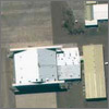
11. North
Korea, 2001
This
IKONOS commercial satellite image of North Korea's No Dong missile test pad
represented the first use of high-resolution commercial satellite imagery by a
non-governmental organization (NGO) to independently examine a facility that
concerned the U.S. intelligence community. The Federation of American
Scientists ordered and published this image to influence public opinion. This
and related images revealed that No Dong is rather unimpressive compared to
missile launch sites in other countries; it's smaller, for instance, and has
only a dirt road leading to it. Hardliners in the U.S. government who had been
agitating about the North Korean missile program withheld releasing the image
out of concern that the public might conclude that the North Korean missile
program was not as advanced as the intelligence community and legislative
supporters of missile defense claimed. In the image, the circle in the center
is the missile launch platform, while the diagonal dark rectangle below it is
the shadow cast by the missile erector.
|
|
|
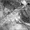
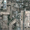
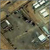
12. Qatar,
2002
Taken by
DigitalGlobe, a commercial satellite company, this image of the U.S.-leased Al Udeid airbase in the tiny
Persian Gulf country of Qatar quickly and visibly drew domestic and
international attention to the ongoing U.S. military buildup in the Persian
Gulf in preparation for a possible war with Iraq. The image, which the
GlobalSecurity.org Web site made public, was the single most requested image in
the Web site's history, generating stories by major U.S. and foreign broadcast,
print, and other media. The planes to the right are KC-135R Stratotanker
refuelers, while the lone plane to the left is a C-17 Globemaster transport.
|
|
|
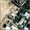
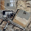
13. Iraq,
2002
GlobalSecurity.org
posted this image showing new construction (in enlarged boxes) at the Tuwaitha
nuclear research center southeast of Baghdad, Iraq. The Iraqi Foreign Ministry
immediately responded by showing a picture of the image at a press conference
and denying that the facility was being used for military purposes. The Iraqis
then led Western journalists on a carefully controlled guided tour of portions
of the facility to demonstrate that it did not have WMD function. The release
of the Tuwaitha image marks the first time that an NGO has successfully used
commercial imagery to influence the behavior of a country believed to be
illegally pursuing a WMD capability.
|
|
|
14. Iran,
2003 & 2005
This
hardened underground uranium enrichment facility near the city of Natanz, Iran illustrates both the ability to detect
construction of ongoing nuclear facilities and the limits of imagery to divine
political intentions. Did the Iranians construct this hardened underground
facility knowing that it would be used in a nuclear weapons program? Or was it
part of a peaceful, commercial nuclear fuels program and they feared it would
be attacked if aboveground? The imagery alone has yet to solidify international
resolve.
|
|
|
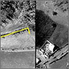
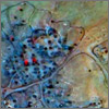
15. Sudan,
2004
Commercial
satellite imagery can identify ethnic cleansing and humanitarian crises when
"cued" (or supplied precise coordinates on where to point a
satellite) by other sources, including humanitarian relief organizations and
NGOs on the ground. Unfortunately,
while convincing to expert eyes, the images alone may not be persuasive enough
to help solve such crises. A glaring case in point is imagery of Darfur
released by the U.S. State Department in 2004 (left) and by humanitarian groups in
2007, which has not succeeded in motivating international organizations to apply
the necessary political pressure and sanctions on the Sudanese government to
end what appears to be genocide. In a
case such as that in Darfur, "ground-truth" imagery, when available
from on-site sources, is often more dramatic and thus more persuasive in making
the case of genocide than blurry images from orbit. In this detail from an image of a destroyed village near Shataya in Darfur taken on June 21, 2004, black rings are foundations of destroyed huts, while red areas indicate remaining healthy vegetation.
|
|
|
16. Afghanistan,
2005
Overhead
imagery of a CIA Field Station north of
Kabul, Afghanistan helped
illustrate and draw international attention to a secret CIA program known as
"extraordinary rendition." In this program, battlefield combatants were interrogated and later
transported to countries where interrogation methods were harsher than those
permitted under U.S. law. This CIA station was located only after the general
description of the facility's location was "leaked" by a knowledgeable insider in the U.S.
intelligence community.

|
|

We recommend you visit the interactive version. The text to the left is provided for printing purposes.
|