
|
 |
||
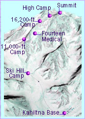
Climb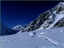 Kahiltna Base
Having flown up to 7,200 feet onto the glacier by bush plane, you're now on a crevasse field on the southeast fork of the Kahiltna Glacier, 15.5 miles from Denali's summit. Camp is an international scene, buzzing with activity; many climbers are camped here sorting their gear for the upper mountain and others are waiting to fly out, having already made their attempts on the mountain. Kahiltna Base to Ski Hill Five and a half miles up the Kahiltna Glacier lies camp at the base of Ski Hill. From Base, wearing skis or snowshoes, you'll descend Heartbreak Hill and swing out wide onto the main Kahiltna Glacier to avoid large crevasses. 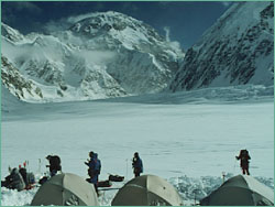 Ski Hill Camp
The first camp above Base sits at 7,800 feet at the base of Ski Hill. You can use the snow walls erected by previous teams, and you'll camp in the company of other teams heading up the mountain. You will have to probe the campsite for potential crevasses and then mark its boundaries with long bamboo poles called wands. Never leave camp boundaries unroped. Ski Hill Camp to 11,000-foot Camp Ski Hill is a 1,000-foot gain in elevation up a long hill. Many teams will stop and camp at 9,700 feet, 2.5 miles from Ski Hill Camp. Continue up to 10,000 feet and then turn east, away from Kahiltna Pass, as you continue to 11,000 feet at the base of Motorcycle Hill. 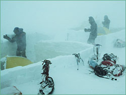 11,000-foot Camp
Located at the base of Motorcycle Hill (named after the equally steep hills motorcyclists are known to ascend in competition), this camp is famously windy. Avoid potential avalanches and ice falls coming off the ridges to the northwest. 11,000-foot Camp to Fourteen Medical This climb can only be done in good weather with reasonable assurance of low winds for the traverse around Windy Corner. 2.75 miles up the route and into a wide crevasse-ridden basin lies camp at just above 14,000 feet. 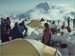 Fourteen Medical
This camp, a small village of tents, will serve as our Advance Base Camp, set on a large plateau at just above 14,000 feet. All West Buttress expeditions use this camp for acclimatization and as a staging area for the upper mountain. The National Park Service has a large medical tent here for their rescue and medical operations. Fourteen Medical to 16,200-foot Camp To the north of camp, climbers must ascend the fixed ropes of the 800-foot vertical face of the Headwall, the steepest section of the West Buttress route. Ridge Camp sits at the top of the Headwall. 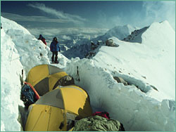 16,200-foot Camp
This is a very exposed camp at 16,200 feet, which has been the site of many harrowing experiences for climbers stranded in bad weather. Tent platforms must be chopped out of the sloping ice and snow to provide a flat space for camping. 16,200-foot Camp to High Camp The most spectacular section of the West Buttress Route, the .75-mile ridgeline above 16,200-foot Camp, offers stunning views and dramatic exposed climbing. Fatal falls and frostbite have occurred here to many climbers who have tried ascending in marginal weather. 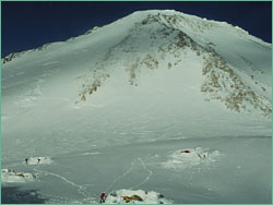 High Camp
This 17,200-foot camp is Denali's highest, coldest, and windiest camp. Many climbers have been caught up here for days, battling the weather, waiting to get up or down the mountain. Fourteen Medical Camp can be seen 3,000 feet below, but is well beyond the reach of rescuers when the weather is bad. High Camp to the Summit The longest and most strenuous day on Denali will be the summit day, a 5-mile round trip back to High Camp. Climbers ascend Denali Pass in the cold morning air, until they cross a high flat plateau called the Football Field. The Summit Ridge begins at 20,100 feet, leading climbers up the last 220 vertical feet to the summit. 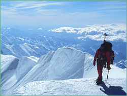 Summit
You've reached the highest point in North America: 20,320 feet with a spectacular view. Climbers spend very little time up here as they still have 2.5 miles of descending ahead of them before they will reach the safety of their tents at High Camp. Photos: (1) Liesl Clark; (2-7) Brian Okonek, Alaska Denali Guiding, Inc. Climb | Expedition | Mountain of Extremes Denali for Kids | Dispatches | E-Mail | Resources Site Map | Surviving Denali Home Previous Sites | Adventures | Join Us/E-mail | TV/Web Schedule Teachers | Site Map | Search | Shop | To print PBS Online | NOVA Online | WGBH © | Updated June 2000 |
|
|