 |
 |

|
Midnight Express January 31, 1998 By Mark Hoover previous | next El Niño is brewing bad weather way out in the Pacific this weekend, weather that's headed east. The storm flights are on, and I'm on my way to Monterey, California. Back-to-back storms—the strongest of the season—are forecast to hit the west coast Monday, Tuesday, and Wednesday. If the jetstream keeps twitching like it has been this week, it looks like California may be ready for a drubbing.
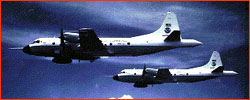
Last night I spoke with Nick Bond out in Anchorage. A NOAA meteorologist from Seattle, Bond is studying how these winter storms form in an El Niño year. (We'll be meeting up with Nick Bond next week to take another flight - this time in the jetstream.) Nick says these storms are "beautiful specimens"—which means they're pulsating with high-speed winds and a heavy load of moisture that's going to be dumped like Niagara on whatever land the storms eventually pass over. In Monterey, home base for the researchers I'm flying with, Ola Persson is excited. Persson is a lead scientist for CALJET, the project behind these storm flights. Data gathered from the flights and a host of other instruments will be used to improve forecasting techniques. The plan right now is to fly every day for three or four days in a row, beginning on Sunday night, as soon as the storms have lined up off the coast. Each flight can take ten hours, making for a grueling schedule for scientists and planes alike. However, with storms like these new ones coming in, it's worth it. Already this past week, the team has been caught off guard by some of their findings, and that makes them happy. This is how science advances—not when something happens to confirm the theory—but when something happens to confound it. The weather guy on the six o'clock news may make forecasting seem like a well-established science, but don't be fooled by the fancy graphics and the perfect hair. Weather prediction is a science with a lot of raw edges and unsolved problems. I'm packing my gear right now, checking batteries, and testing the mikes. I've been told to report at the Monterey airfield late tomorrow afternoon for a briefing. Then I'll grab a sandwich and some Dramamine. If the storms keep moving as expected, the flight will take off a little before midnight—a night flight in total darkness on the Midnight Express, out to meet a major storm a thousand miles west of Monterey. After flying directly into the heart of the storm, we will make a series of runs down low, 50 or 60 meters above the waves, gathering information on jets of air near the surface. In an airplane, that's low. Persson is quick to point out the superb safety record of NOAA's P-3s. So why did he then casually mention that we'd all be wearing flotation vests? Draw your own conclusions.
After a night of pounding by the storm as we probe its secrets, we'll land
sometime after dawn on Monday, and I'll begin transmitting the sights and
sounds of storm flying—as well as the science—back to this Web site.
Dispatches | Resources | Mail | Site Map | El Niño Home Editor's Picks | Previous Sites | Join Us/E-mail | TV/Web Schedule About NOVA | Teachers | Site Map | Shop | Jobs | Search | To print PBS Online | NOVA Online | WGBH © | Updated November 2000 |
||||
