 |
 |

|
Advance Warning (continued) (back) 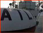 In yet another failing, no computer model of the time had yet focused on the
key interactions between the sea and the air above it as the essential feature
of El Niño. Mostly, they tended to look either at changes in the ocean,
or changes in the winds, but not very much at the dynamic feedback systems
between them. Since 1982, most models (and scientists) have come full circle,
and concentrate on the so-called "dance" between the ocean's surface layer and
the winds as the critical element. But in 1982, roughly speaking, you were
either an oceanographer or a meteorologist, and you tended to ignore whatever
your discipline excluded. Computer models programmed by oceanographers
concentrated on the ocean; models made by meteorologists looked mostly at the
winds.
In yet another failing, no computer model of the time had yet focused on the
key interactions between the sea and the air above it as the essential feature
of El Niño. Mostly, they tended to look either at changes in the ocean,
or changes in the winds, but not very much at the dynamic feedback systems
between them. Since 1982, most models (and scientists) have come full circle,
and concentrate on the so-called "dance" between the ocean's surface layer and
the winds as the critical element. But in 1982, roughly speaking, you were
either an oceanographer or a meteorologist, and you tended to ignore whatever
your discipline excluded. Computer models programmed by oceanographers
concentrated on the ocean; models made by meteorologists looked mostly at the
winds.In short, when they had the chance to foretell one of the century's major weather events, the specialists were wrong. If a roomful of the top El Niño scientists in the world could argue at an international meeting about whether or not they were ready to detect the next El Niño—while in the ocean the next El Niño had been building unnoticed for six months or more—the science of prediction clearly had a long way yet to go. At the same time the scientists were meeting in New Jersey, a young researcher named John Toole was on an oceanographic ship off the coast of South America. He and others were periodically dunking a temperature and salinity measuring device called a CTD over the side of the ship, taking a series of readings in a line right up the coast. The temperature readings they were getting were astonishing; near the equator, the sea was as much as six degrees Celsius (over ten degrees Fahrenheit) above normal. Toole didn't throw out his data, he threw out the satellite data. He could trust what he could see with his own eyes and feel with his own skin. It was John Toole, working with his mentor
Mike McPhaden is now the chief scientist of the program that grew out of the discomfiture of 1982. Stan Hayes, his predecessor, deserves the credit for thinking up the TOGA/TAO array following the 1982 folly, and for spending 10 years proving the concept and convincing the budget overseers that it was worth funding. Tragically, Stan Hayes became ill with cancer as the array neared completion; nevertheless, he carried on with his work right until his death in 1992, leaving behind an indelible testament to the power of scientific vision and persistence.
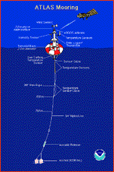
The buoys, called ATLAS (for Autonomous Temperature Line Acquisition System), are rugged little floating weather stations designed to last a year or more without attention. Much like NASA's celebrated new "faster, cheaper, better" programs, the ATLAS buoys combine ingenious technology and off-the-shelf parts into instruments that offer amazing performance for the price. For example, the electronics use sophisticated microprocessor controls, and are custom designed for the instrument pack...but the energy source is plain old alkaline D-cells from Radio Shack. The anchors are recycled railroad car wheels, 4,000 pounds worth, but the mooring lines are attached to them via acoustic couplers, which sit on the anchor at the bottom of the sea for a year, listening for an acoustic signal fired from the service ship that tells them to release the cable and free the buoy. The instrument-pack design foregoes costly current-measuring devices, and concentrates on reliable and maintenance-free temperature and wind devices. As Mike McPhaden puts it, "we don't put Cadillacs out there, we put Chevys...we trade fancy for reliable, and it's worked out great so far." Indeed. Using a specially-equipped ship, the Ka'imimoana—and to a lesser degree, the assistance of international partner ships from Japan, Taiwan, Korea, and France—McPhaden's group at the Pacific Marine Environmental Lab maintains one of the largest scientific instruments ever built, deployed across thousands of miles of blue ocean. They're able to keep the network running with an average time between calls to each buoy of a year. Most of the buoys 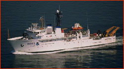 are still working fine after that year has passed...in fact, McPhaden says the
biggest problems are due to vandalism by fishermen, and not to equipment
failure. And the cost of this grand program? "About eight million dollars a
year," says McPhaden. "Somewhere between a tenth and a hundredth the cost of a
single satellite program. A bargain any way you look at it." Considering that
the damage toll for this year's El Niño alone will surely measure many
billions, it's hard not to agree with McPhaden that TOGA/TAO provides a very
cheap advance warning.
are still working fine after that year has passed...in fact, McPhaden says the
biggest problems are due to vandalism by fishermen, and not to equipment
failure. And the cost of this grand program? "About eight million dollars a
year," says McPhaden. "Somewhere between a tenth and a hundredth the cost of a
single satellite program. A bargain any way you look at it." Considering that
the damage toll for this year's El Niño alone will surely measure many
billions, it's hard not to agree with McPhaden that TOGA/TAO provides a very
cheap advance warning.To see how much impact such a warning can have, take a look at another highly visible El Niño warning system—the media—which now seems entrenched as an alarm system for the masses; few phenomena have invaded the national consciousness in recent years as El Niño has. People who
The data collected by the TOGA/TAO array remains the standard against which all others are calibrated. Combined with satellites, other measuring devices, and the latest computers, TOGA/TAO forms the heart of a system that for the first time is able to provide up to a year's reliable notice of an impending El Niño. The embarrassment of 1982 has been erased. Although this is a young science, and there is still a lot to learn, Mike McPhaden, the crew of the Ka'imimoana, and the staff at the Pacific Marine Environmental Lab in Seattle are the first line in a detection system that doesn't expect to be fooled again. Meanwhile, the modellers are getting a lot better, too, in part because of the excellence of the data they feed into their computers. Even though the top model failed this year, most of the other contenders predicted some sort of warm event. In any event, these are flush times in the climate community. With tools like the TOGA/TAO array, ever-faster computers, and the insights that will inevitably accrue from the current worldwide fascination with El Niño, climatologists can literally look ahead to a time when El Niño will seem less a monster and more...a child. 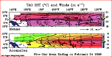
Photos/Images: (4-6) NOAA. Anatomy of El Niño | Chasing El Niño | El Niño's Reach Dispatches | Resources | Mail | Site Map | El Niño Home Editor's Picks | Previous Sites | Join Us/E-mail | TV/Web Schedule About NOVA | Teachers | Site Map | Shop | Jobs | Search | To print PBS Online | NOVA Online | WGBH © | Updated November 2000 |
||||||||||||
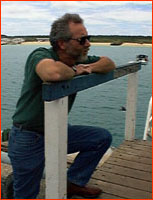 Mike McPhaden
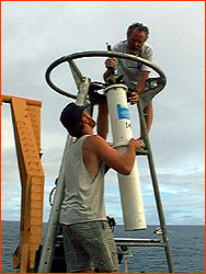 Preparing an ATLAS buoy.