NOVA Online
Everest
Site Map

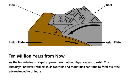
Birth of the Himalaya (Non-Shockwave)
back to Birth of the Himalaya

diagram of Indian plate sliding toward Asian plate; junction with Tethys sea between. Text reads 'Sixty Million Years Ago: India collides into the Asian Plate. This movement is what eventually causes the Himalayan Range, as the two plates push against each other and the earth's crust is squeezed upwards.'


diagram of Indian plate sliding under Asian plate; junction with Tethys sea between. Text reads 'Forty Millions Years Ago: Heavy sediments on the ocean floor sink under the Asian Plate, slowly closing up the Tethys Sea. The Indian Plate is colliding even deeper into Tibet.'


diagram of Indian plate sliding under Asian plate; Tethys sea gone. Text reads 'Twenty Million Years Ago: The Tethys sea is completely gone. Heavy sediments from the ocean floor are pushed up to form the Himalaya. Tibet begins to rise.'


diagram of Indian plate sliding under Asian plate; junction at Nepal/Tibet. Text reads 'Today: Through GPS technology, we know that 19 kilometers below the surface of the earth, India continues to move northward under Tibet at 18 mm/year. The greater Himalaya (including Everest) are rising at approximately 5 mm/year as a result of squeezing motions between India and Tibet.'


diagram of Indian plate sliding under Asian plate. Text reads 'Ten Million Years from Now: As the boundaries of Nepal approach each other, Nepal ceases to exist. The Himalaya, however, still exist, as foothills and mountains continue to form over the advancing edge of India.'


Lost on Everest | High Exposure | Climb | History & Culture | Earth, Wind, & Ice
E-mail | Previous Expeditions | Resources | Site Map | Everest Home

Editor's Picks | Previous Sites | Join Us/E-mail | TV/Web Schedule
About NOVA | Teachers | Site Map | Shop | Jobs | Search | To print
PBS Online | NOVA Online | WGBH

© | Updated November 2000