 |
 |
 |
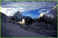 Earthquake in the Himalaya
part 2 | back to part 1 To make life easier, Roger is currently working on the placement of ten continuous-reading GPS stations in the Himalaya that will operate round the clock. He placed one of these during our approach to Base Camp at Namche Bazaar, at 3,500 meters, and another on the peak of Kala Pattar, overlooking Base Camp. Expedition climbers will place a third one on Everest's South Col, at 7,906 meters. By taking measurements continuously, scientists have a much larger sample, and errors can be reduced from 3 millimeters to 1 millimeter, even over hundreds of kilometers of distance. These survey points are linked by radio telemetry and e-mail to Kathmandu and Boulder, Colorado. "The GPS point set up at Namche has already revealed some very interesting data," says Roger excitedly. "We think that Namche is situated above the point where the Indian Plate starts being able to slide easily beneath Tibet. 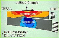 At a
depth of 10 kilometers, points south of Namche are glued to the bottom of the
Himalaya and are being driven toward Tibet. Surface points north of Namche are
evidently prevented from moving north, and act increasingly as a battering ram,
hindering the movement of Himalayan rocks northward. As a result, the area is
getting squeezed, like winding up a terrific spring. In the last 5 years,
we've watched that spring gently being wound up. This buildup of elastic
energy will eventually result in a catastrophic earthquake." The forces build
up more and more until eventually something snaps, and when it does, Roger
predicts that the Himalaya will leap forward a meter or more in less than a
minute. Click here to hear Roger equate the Himalaya to a pile of bricks (RealAudio). At a
depth of 10 kilometers, points south of Namche are glued to the bottom of the
Himalaya and are being driven toward Tibet. Surface points north of Namche are
evidently prevented from moving north, and act increasingly as a battering ram,
hindering the movement of Himalayan rocks northward. As a result, the area is
getting squeezed, like winding up a terrific spring. In the last 5 years,
we've watched that spring gently being wound up. This buildup of elastic
energy will eventually result in a catastrophic earthquake." The forces build
up more and more until eventually something snaps, and when it does, Roger
predicts that the Himalaya will leap forward a meter or more in less than a
minute. Click here to hear Roger equate the Himalaya to a pile of bricks (RealAudio). Because the movement between India and Tibet is roughly 2 centimeters per year,
that means every 100 years you have 2 meters of potentially built-up pressure
ready to be released. And if you wait 300 years, that means 6 meters of
potential energy. With a large earthquake, the "slip" of energy could reach a
magnitude exceeding 8 on the Richter scale. This is equivalent to about 1000
megatons of nuclear explosive.
Because the movement between India and Tibet is roughly 2 centimeters per year,
that means every 100 years you have 2 meters of potentially built-up pressure
ready to be released. And if you wait 300 years, that means 6 meters of
potential energy. With a large earthquake, the "slip" of energy could reach a
magnitude exceeding 8 on the Richter scale. This is equivalent to about 1000
megatons of nuclear explosive.The rate of increase of this seismogenic strain can then be used to estimate the time between great earthquakes. Scientists are concerned, because it is now believed that the seismic waves occurring when this elastic energy is released the Himalaya will reflect this energy mostly to the south. Normally the energy radiates in all directions. To make matters worse, the intensity of this energy focuses and increases as these waves pass through the gradually narrowing bands of Himalayan sediment in southern Nepal and northern India. As a result, northern India, which is heavily populated, could experience a more severe jolt than points closer to the nucleation of the quake itself. "We can't pinpoint the date of future earthquakes, but we can now say that they definitely will happen, what their magnitude and acceleration (another measure of destructive intensity) is likely to be, and even where these earthquakes are nucleated." Liesl Clark, NOVA Online's producer and writer, joined the 1996 expedition up to Base Camp. Broughton Coburn, author and long time resident of Nepal is an advisor to MacGillivray Freeman Film's IMAX/IWERKS 1570 large format film "Everest." Photos: (1, 3) courtesy Sumiyo Tsuzuki; (2) courtesy Robert Schauer. Lost on Everest | High Exposure | Climb | History & Culture | Earth, Wind, & Ice E-mail | Previous Expeditions | Resources | Site Map | Everest Home Editor's Picks | Previous Sites | Join Us/E-mail | TV/Web Schedule About NOVA | Teachers | Site Map | Shop | Jobs | Search | To print PBS Online | NOVA Online | WGBH © | Updated November 2000 |