 |
 |
 |
 South Side Story
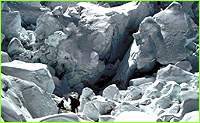
part 2 | back to part 1 Within a few days the party had reconnoitered a route through the Icefall to a point where a continuous lateral crevasse separated the Icefall from the Western Cwm above. Examination from high on the slopes of nearby Pumori had already indicated that the Cwm gave easy access to the West Face of Lhotse, from which the South Col of Everest could be reached by a gently rising traverse. They continued to explore the area, hoping that conditions might improve later in the season, but when the team tackled the Icefall again towards the end of October, they failed to climb as high. Nevertheless, the route had been identified which would eventually lead Ed Hillary and Sherpa Tenzing Norgay to the summit. 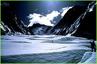 The following year the Swiss made their bid under the leadership of Dr. E.
Wyss-Dunand. They successfully crossed the final crevasse into the Western
Cwm, which they evocatively called 'the Valley of Silence,' and on May 26th
Raymond Lambert and Tenzing Norgay camped in a tiny tent at 27,500 feet, ready
to make a bid for the summit the following day. They were under-equipped,
however, and with no means of cooking, unable to drink or eat enough to keep up
their strength. Their attempt failed at 28,210 feet, just below the South
Summit. Another Swiss expedition that autumn failed to match this sterling
effort. The stage was set for the British Expedition of 1953, Coronation year,
to be led by Colonel John Hunt.
The following year the Swiss made their bid under the leadership of Dr. E.
Wyss-Dunand. They successfully crossed the final crevasse into the Western
Cwm, which they evocatively called 'the Valley of Silence,' and on May 26th
Raymond Lambert and Tenzing Norgay camped in a tiny tent at 27,500 feet, ready
to make a bid for the summit the following day. They were under-equipped,
however, and with no means of cooking, unable to drink or eat enough to keep up
their strength. Their attempt failed at 28,210 feet, just below the South
Summit. Another Swiss expedition that autumn failed to match this sterling
effort. The stage was set for the British Expedition of 1953, Coronation year,
to be led by Colonel John Hunt.Photos: (1-2) courtesy David Breashears. Lost on Everest | High Exposure | Climb | History & Culture | Earth, Wind, & Ice E-mail | Previous Expeditions | Resources | Site Map | Everest Home Editor's Picks | Previous Sites | Join Us/E-mail | TV/Web Schedule About NOVA | Teachers | Site Map | Shop | Jobs | Search | To print PBS Online | NOVA Online | WGBH © | Updated November 2000 |