See Spy Photos
- By Tim Brown
- Posted 02.12.08
- NOVA
Surveillance images taken by spy planes and satellites have been used to sway public opinion ever since President Kennedy declassified U-2 images of Russian nuclear missiles in Cuba four decades ago. Since then, the release of such photographs—sometimes officially sanctioned, sometimes not—has played a crucial role in geopolitics, never more intensely than in recent years. In this interactive satellite map of the world, examine a series of influential images released between 1962 and 2005.
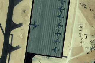 Launch Interactive
Printable Version
A surveillance-image specialist analyzes photos of Afghanistan, Iraq, North Korea, and other political hotspots.
This feature originally appeared on the site for the NOVA program Astrospies.
Credits
Images
- (map)
- © Planetary Visions
- (Poland)
- The U.S. National Archives and Records Administration
- (Cuba, Nicaragua, Soviet Union 1983, Afghanistan 1998)
- © U.S. Government
- (Soviet Union 1986)
- © SPOT/EOSAT
- (Kosovo)
- ©Agence France-Presse/CORBIS
- (United States, Israel, China, North Korea, Iran, Afghanistan 2005)
- © Space Imaging—www.spaceimaging.com
- (Qatar, Iraq, Sudan)
- © DigitalGlobe
Related Links
-

The Spy Factory
Examine the high-tech eavesdropping carried out by the National Security Agency.
-
Cryptography 101
Learn different ways to make a message secret.
-
Space Race Time Line
Examine turning points in the history of the heated competition between the U.S. and USSR to dominate space.
-
The Space Race Today
Historian Asif Siddiqi discusses the blossoming space programs of China, India, and other comparatively new players.
You need the Flash Player plug-in to view this content.

