|
|

|
|
Introduction
Glacier hazards represent a continuous threat to human lives and infrastructure
in mountain regions. Outbursts of glacier lakes, ice break-offs and subsequent
avalanches, and related disasters can kill hundreds or even thousands of people
at once and cause damage with a worldwide annual sum in the tens of millions of
dollars. Global warming is exacerbating the situation by causing rapid changes
to glaciers and glacier lakes. For this reason, and because the remoteness of
glaciers makes ground-based observations difficult, satellite imagery has
become an invaluable tool—and sometimes the only tool—for glacier
hazard assessment. Here, view a series of glacier-related disasters and hazards
imaged by a NASA satellite for the international Global Land Ice Measurements
from Space, or GLIMS, project.—Andreas Kääb
Andreas Kääb, a lecturer and senior research associate in the
Department of Geography at the University of Zürich-Irchel, is chair of
the International Working Group on Glacier and Permafrost Hazards in Mountains.
|
|
|
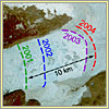
Rapidly Discharging Glacier, Greenland
While most glacier hazards are felt locally, one has a global impact, and that is sea-level
rise caused by the rapid melting or discharging of glaciers. One of the glaciers of greatest
such concern is Jakobshavn Isbrae in western Greenland. This is the world's fastest-moving
glacier, and between 1997 and 2003, it nearly doubled its speed and discharge of ice. The
image at right shows the striking retreat between 2001 and 2004 of Jakobshavn's calving
front—the leading edge where the glacier breaks off into icebergs that eventually get
pushed out to sea. Apart from local hazards to shipping from more icebergs, such enhanced
ice release to the ocean from this and other fast-moving glaciers has the potential to
significantly increase global sea-level rise, which is currently about two to four
millimeters per year. While this may sound modest, over decades the cumulative effect
will mean increased flooding to coastal communities, with adjustments to harbors, seawalls,
and other coastal infrastructure reaching into the billions of dollars.
|
|
|
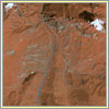
Collapsing Glacier, Russia
Ice collapses and the avalanches they can trigger are one of the gravest
dangers that glaciers present. In the late evening of September 20, 2002, a
rock-and-ice avalanche began on a peak high above the village of Karmadon in
the Russian Caucasus. The avalanche fell onto the tongue of the Kolka glacier,
shearing it off and triggering a massive landslide containing tens of millions
of cubic yards of rock, mud, and ice. This rushed down the valley at speeds of
over 60 miles per hour, burying the lower parts of Karmadon (center of images)
and killing more than 120 people. The "before" image was taken on July 22,
2001, and the "after" image on September 27, 2002, a week following the
disaster. By this date, lakes (the largest visible in the center right of the image)
had begun to form as the landslide blocked
rivers. Close to 10 million cubic yards in volume, these lakes posed a danger
of outburst and catastrophic downstream flooding.
|
|
|
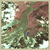
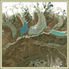
Glacier Lake, Italy
Meltwater lakes can form on top of glaciers, threatening potentially disastrous
floods if they burst forth. Careful monitoring of the Belvedere Glacier in the
Italian Alps began in the mid-1980s following an outburst in 1979 of the moraine lake
Lago delle Locce (dark blue lake to right of glacier). This monitoring
was fortunate, because in June 2002, authorities discovered that a tiny lake
that had developed the previous summer atop the Belvedere Glacier had grown to
an exceptionally large lake with a volume of some three million cubic yards
(see aquamarine lake in center of both images). When discovered, the lake level
was rising at up to a yard a day and had only a few yards of freeboard
remaining. The Italian Civil Defense Department and the scientists involved
initiated emergency actions. These actions, together with natural drainage and
a cold spell in early July, helped return the lake size to that seen in the
first image by October 2002. When the lake grew to a similar huge size in
spring 2003, the authorities were prepared and were able to avert a damaging
flood.
|
|
|
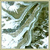
Retreating Glacier Lakes, Bhutan
Retreating valley glaciers often leave behind glacier lakes in front of or
within their melting tongues. Nearly all glaciers in this image of the Bhutan
Himalayas show lakes at their tongues. Once such a lake has formed, melting and
retreat of the glacier front accelerates because water transports heat much
more efficiently to the ice front than air can. The Bhutan Himalayas currently
host more than 2,500 glacier lakes. On October 7, 1994, the greenish lake to
the right in this image, Lugge Tsho, partially burst out. Though the impact in
this lightly populated area was minimal—12 houses were damaged, five water
mills washed away, and about 800 acres of land damaged—traces of the
subsequent debris flow down the valley remain visible seven years later in this
2001 image. The glacier tongue seen in the middle of the image, between the
blue and green lakes, shows clearly how small ponds forming on a melting
glacier tongue can rapidly grow and connect with one another to form large,
potentially hazardous lakes.
|
|
|
Bursting Glacier Lake, Nepal
On August 4, 1985, Dig Tsho, a lake in the Mt. Everest region of Nepal, burst
out, spilling an estimated 200 to 350 million cubic feet of icy water. The
resulting flood wave, an astonishing 35 to 50 feet high, barreled down the
valley for roughly 55 miles. Altogether, a $1.5 million hydropower
installation, 14 bridges, and various trails and patches of cultivated land
were destroyed. Such damages hit people in mountainous developing countries
like Nepal especially hard. No land is available on the steep valley flanks for
affected families to relocate to, and the destroyed infrastructure might have
been the first step toward increasing the area's low standard of living. As is
typical of many glacier floods, the outburst of Dig Tsho was triggered by an
ice avalanche that crashed into the lake from an adjacent glacier. The
resulting impact wave traveled to the moraine dam, overtopped it, and led to
erosion of the dam, which finally broke.
|
|
|
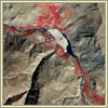
Glacial Debris Flow, Tadjikistan
Chain reactions that enhance the impact of small trigger events often
characterize glacier disasters. Here, a comparably small glacier lake (unseen
below bottom edge of image) in the Pamir Mountains of Tadjikistan in Central
Asia burst out and triggered a debris flow. The corresponding material spilled
into the river (flowing from right to left in image), suddenly damming it. The
tan, mushroom-shaped debris fan is clearly visible at the exit of a gorge into
the main river valley. Officials quickly cut a channel through the far side of
the fan to lower the lake level and prevent an outburst. Note that in this
image, vegetation appears red.
|
|
|
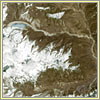
Looped Moraines, Tadjikistan
Glaciers that become unstable and experience exceptionally high advance rates
are called surging glaciers. Sometimes their surge history gets "stored" in
so-called looped moraines. Here, the glacier in the middle shows deformed
("looped") moraines, in contrast to the "straight" moraines in the glacier to
the left. These loops appeared when distinct surges in the tributary glacier
(lower left in image) pushing into the main glacier deformed and transported
its ice and debris cover, thereby storing the surge history. If a glacier surge
leads to a rapid advance of the affected glacier, it may override and dam
rivers too quickly to allow for slow drainage of the dammed river. A dangerous
lake can develop and a corresponding flood hazard threaten people and
infrastructure down-valley.
|
|
|
Surging Glacier, Alaska
Surging glaciers can sometimes divide a lake or fjord into two parts, creating
a hazardous situation. In May 1986, and again in 2002, the advancing Hubbard
Glacier in Yakutat Bay, Alaska, blocked the entrance to Russell Fjord (lower
right in image). Dammed meltwater from surrounding glaciers raised the fjord's
water level by up to 82 feet above sea level before the ice dam failed on
October 8 of that year. In spring 2002, the advancing Hubbard Glacier again
closed the opening between Disenchantment Bay (lower left) and Russell Fjord.
The level of the ice-dammed fjord increased by nearly 66 feet. On August 14,
2002, the dam broke, reestablishing the connection to the bay. Since no one
lives directly downstream, both breaks caused only natural damage. A major
hazard would develop, however, if the Hubbard ever permanently blocked Russell
Fjord. This could lead to overflow and drainage at the fjord's back side (not
shown), which would endanger areas around the village of Yakutat.
|
|
|