| |
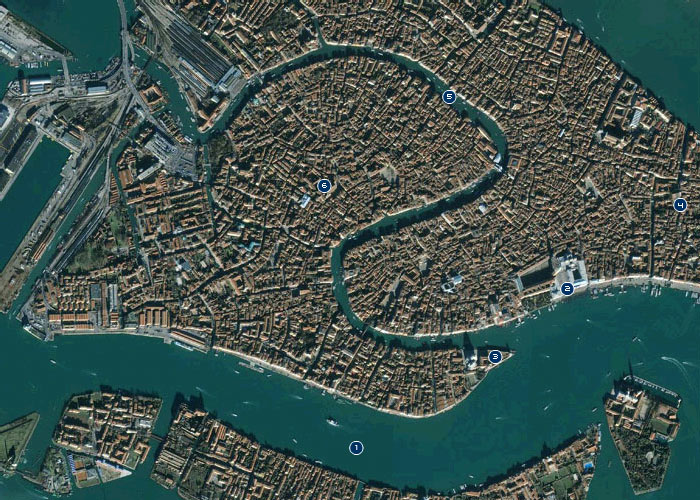
1. Sea level
The rise in global sea levels over the past century has resulted in an increase
in the mean sea level at Venice of over three inches since 1897. Coupled over
the same period with a lowering of the land beneath Venice of six inches, large
portions of the city are left awash on far too many days of the year.
2. Square
In 1900, water at extreme high tide spread across Venice's treasured St. Mark's
Square seven times—and this was typical for the time. By 1996, the city
flooded 99 times. The dousing threatens famous edifices like St. Mark's
Basilica and the Doges' Palace and makes it difficult to deliver goods and
simply get around, even on the raised wooden walkways erected in times of
flood.
3. Tidal gauge
In 1897, Venetians established a tidal gauge near the church of Santa Maria
della Salute, with the zero mark indicating mean sea level. At the time,
average tides in the northern Adriatic (without meteorological interference)
oscillated between roughly a foot above and a foot below this mean level. They
fluctuate similarly today; the trouble is that the mean sea level in and around
Venice is now over nine inches higher than it was in 1897.
4. Ground level
Since 1897, natural compression of sediments beneath the city has resulted in a
lowering of the ground level by about an inch and a half. More significantly,
subsidence brought about by the pumping of freshwater from an aquifer beneath
the lagoon between the 1920s and early 1970s left Venice resting a good four
and a half inches lower in the lagoon. Subsidence in the historic center is
most pronounced in Castello, the city's easternmost district.
5. Canal
The city's vulnerability is most evident along urban canals. Motorboat wakes
batter buildings, damaging their footings and foundations and exacerbating the
deleterious effects of exceptionally high water, or acqua alta. The
highest tides disrupt commerce and transportation by making it impossible for
boats to pass under bridges.
6. Building
In the 1600s, normal tides seldom rose over the stone footings at the base of
buildings; today, they do so regularly. The outcome is risalta salina,
or salt rise, as seawater creeps into permeable stucco and brick above
foundations of impervious Istrian marble. Maintenance is challenging and
costly, but if it's neglected, crumbling and even collapse can result.
 Satellite view of lagoon

|
 |
|
| |
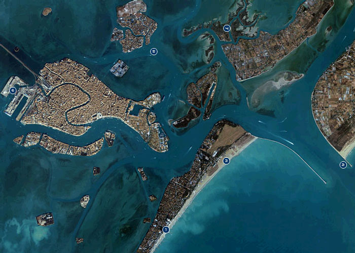
1. Sea wall
In the 14th century, Venetians built defenses of wooden piles and rocks to
protect the shoreline against the Adriatic. Four centuries later, as the sea
began to threaten the city itself, they constructed elaborate seawall defenses,
or murazzi. Today, tides regularly breach these walls, making them
largely irrelevant.
2. Jetty
The jetties built at the three entrances to the lagoon have held back more than
the sea. They have acted as barriers to the natural inflow of fresh sand to
replenish beaches within the lagoon; that sand now accumulates abnormally
around the jetties. The stone barriers have also disrupted currents, increasing
coastal erosion.
3. Island
The Lido and other barrier islands serve as naturally built defensive
battlements, yet they are suffering from erosion both natural and human-made.
Waves and currents eat away at the littorals, a process furthered on these
long, narrow islands by houses, campsites, summer beach crowds, and beachgoing
vehicles.
4. Salt Marsh
Salt marshes capture sediment, filter pollutants, and increase the amount of
organic material in the soil. Eelgrass, the chief building block of salt
marshes, also retards erosion, because its long roots consolidate the lagoon
bed. Today, with water pollution killing eelgrass, salt marshes in the lagoon
are suffering.
5. Fishing boat
Certain fishing techniques have a devastating effect on lagoon beds, leaving
them barren. A suction device used illegally by some fishermen, for example,
vacuums up between 16 and 20 inches of bed in a search for clams. All other
organisms unfortunate enough to be in the way get sucked up as well.
6. Tanker
Tankers have ferried more than 12 million tons of chemicals and crude oil
products through the lagoon each year over the past decade. In 1995, five tons
of light crude oil spilled into the lagoon. While the impact from this accident
was minor, experts have estimated that one-third of a large oil tanker's load
could provoke an ecological disaster in the lagoon, severely damaging fish and
mollusk farms, clam gathering, and wildlife.
Satellite view of region
|
|
|
| |
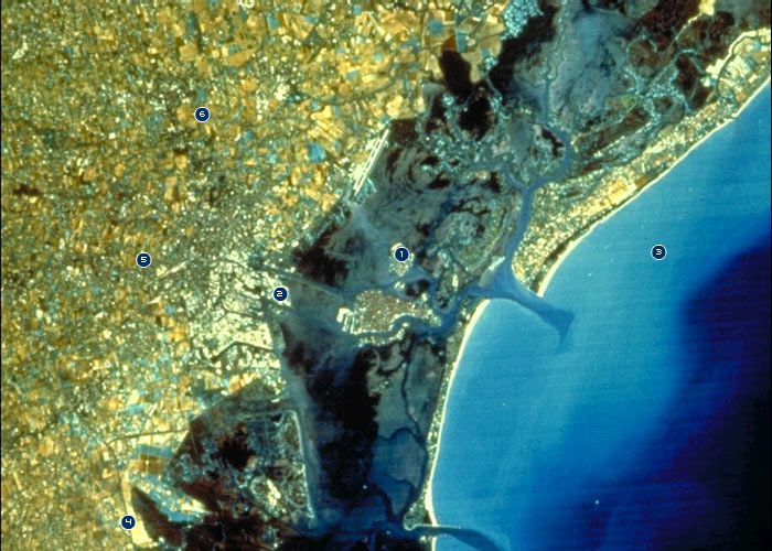
1. Dump
Authorities have identified no fewer than 17 abandoned dumps in the lagoon.
They contain about five million cubic yards of waste material. Rain and tides
help distribute garbage and pollutants from these dumps around the lagoon,
threatening water quality and wildlife.
2. Factory
Between 1950 and 1970 when the industrial zone of Marghera was developed,
refineries, chemical plants, and heavy-metal factories drained their liquid
waste partly into the lagoon and partly into dumps. Today, 80 percent of
Marghera's industrial waste is treated, but the effects of the previous dumping
remain, with currents and erosion continuing to disperse pollutants.
3. Sea
Meteorological conditions can accentuate high tides, worsening the impact of
higher sea levels. Winds like the bora, a cold northerly in the Adriatic Sea,
and the sirocco, a hot, dust-laden wind from the Libyan desert, can trigger
dangerously high tides, particularly during periods of low atmospheric
pressure.
4. River
Centuries ago, in order to halt the silting up of the lagoon, the Republic of
Venice diverted four rivers that originally flowed into the lagoon so that they
emptied directly into the sea. The loss of the silt and sediment that normally
replenished the lagoon has been slowly transforming the delta environment into
a marine one.
5. Farm
While Venetians were able to divert rivers around the lagoon, they were and
continue to be unable to stop runoff from agricultural and livestock farming in
the lagoon's roughly 700,000-square-mile drainage basin. Today, fully 53
percent of the phosphates and other pollutants that enter the lagoon come from
these sources.
6. Town
Venice's drainage basin is heavily developed, with more than 100
municipalities. Nearly half of all pollution that washes into the lagoon comes
from industrial, civil, and urban sources in the region. About 1,400,000 people
live in the basin, but when one considers the quantity of nutrients and organic
matter generated, environmentalists say, it is as if 4,000,000 people lived
there.

|
|


|