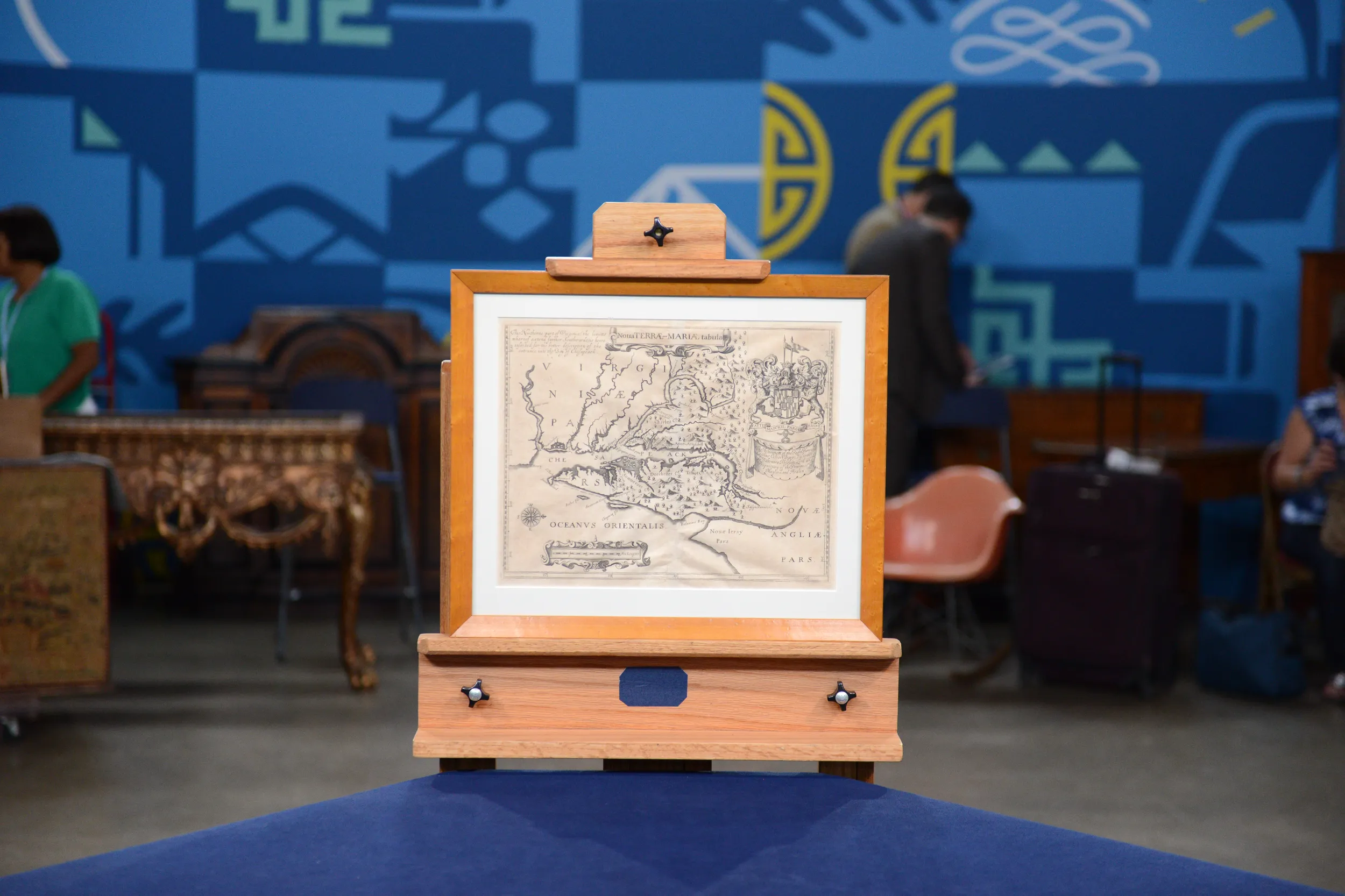
GUEST: I know that it is a 17th century map of Maryland. It was a gift to my father, back in 1954, from his brother, who bought it in London on his way back from the Korean War.
APPRAISER: Okay, it is 17th century, it's from 1671. I ought to help people by putting it into perspective, because it really doesn't look quite like Maryland. It does say up here, "Nova tabla," which is "new map" of land of Maria, or Maryland, but what's strange about it?
GUEST: This part isn't north.
APPRAISER: Right, north is not up! Down here, you can see there's a compass rose, and north is to this direction. Putting north to the top of a map is a convention that we've become very used to, but actually, in the 17th century and before, it was tended to do that, but sometimes for various reasons, they would change it. And this is actually oriented to the west, because this is how you would look at the land when you arrived from overseas.
GUEST: From a ship-- okay.
APPRAISER: You'd be sailing in a ship, and you'd be coming up this way, so that it was laid out in front of you sort of left to right.
GUEST: Okay.
APPRAISER: And so because that's how the people from Europe approached Maryland, that's how they laid out the map.
GUEST: Okay.
APPRAISER: And you can see, here's the Chesapeake Bay running to the north here. So Maryland is basically in this area in here, so that puts it into context.
GUEST: Right.
APPRAISER: As it happens, this is really one of the very earliest maps of Maryland.
GUEST: Oh!
APPRAISER: It is the second version of what's called the Lord Baltimore Map. And Cecil Calvert was Lord Baltimore who was a proprietor of Maryland, and this is his crest right here.
GUEST: Right.
APPRAISER: And this is a second version, it's based on a map from 1635, which was the first version…
GUEST: Oh.
APPRAISER: …which is the first map of Maryland. That one is very, very rare, so this is actually the first obtainable map of Maryland. 17th century maps of any American colony are very rare, and this is quite a rare map. It was done by a man named John Ogilby, and he did update the map. First of all, he moved the border of... this is the border of Maryland, and on the earlier map it was a little too far south. He also added the counties, which was new, and one of the interesting things is, he probably had a connection with Cecil Calvert, because it actually names Cecil County, which is right here, and that wasn't created until three years after this map appeared. So it's likely he got that information and the other information from Lord Baltimore.
GUEST: Okay!
APPRAISER: So he used the first map of Maryland, he updated it with privileged information. So the scarcity, the connection with the history, that's all great, great stuff. American Colonial maps are very, very popular. Did you have any idea of what the value would be?
GUEST: Hmm, no. The only value I know is the six pounds my uncle paid for it in 1954.
APPRAISER: Well, it's worth considerably more than that. Today in the market, this is a map that, in a retail environment, sells for about $8,500.
GUEST: Whoa!
APPRAISER: Yeah, it's a great map, and I was absolutely thrilled when you brought it in.
GUEST: Well, thank you very much.


