Hurricanes
- Posted 01.25.05
- NOVA scienceNOW
(This video is no longer available for streaming.) The city of New Orleans is cradled in swampland. To keep the water out, hundreds of miles of enormous levees and powerful pumps surround the city. But such a fortress is not invincible, and forecasters often have to make tough calls on pending storms. NOVA scienceNOW correspondent Peter Standring investigates what would happen if a hurricane hit New Orleans.
Transcript
Hurricanes
PBS Airdate: January 25, 2005
ROBERT KRULWICH: I wonder if I could have a hurricane, just a small one please. Thank you.
Now, the thing about hurricanes is, if there's one in the neighborhood and you are, say, over here, the first thing you want to know is: "Is it coming at me?" Because, if you're in its path, you're going to want to leave.
Thank you.
But over the years, scientists have gotten pretty good at predicting the direction of a hurricanes but not so good at predicting a hurricane's intensity.
Hurricanes...I'll need one again.
Hurricanes, because of changes in terrain and in water temperature, and all kinds of things down below, can suddenly swell and then diminish and then swell again. And because scientists don't have the tools to read hurricanes that well, these changes are very, very hard to predict—until recently...
Thank you.
...'cause now there's a new development, a kind of CAT scan for hurricanes.
As our correspondent Peter Standring reports, predicting a hurricane's power may now get a little easier.
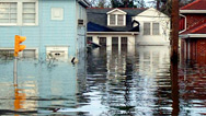
PETER STANDRING (scienceNOW Correspondent): When most people think of New Orleans, they think of the French Quarter, Mardi Gras, jazz, gumbo. But according to federal officials one of the most dire threats facing the nation would be a massive hurricane striking New Orleans. They say that if a major storm had a direct hit here, the effect would be devastating. They're talking perhaps as many as 50,000 dead, up to a million homeless and a city under water. And that disaster nearly happened this past hurricane season.
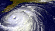
When hurricane Ivan barreled into the Gulf of Mexico, it was on a collision course with New Orleans, a city with a unique vulnerability to hurricanes.
RAY NAGIN (Mayor, New Orleans, Lousiana): This is a very dangerous storm. Hurricane Ivan is approaching us.
PETER STANDRING: Fearing the worst, the mayor called for an evacuation of the city.
MAN: I've been through a couple of hurricanes but this one looks like a monster. I'm hoping it doesn't hit us directly.
PETER STANDRING: Luckily for New Orleans, Ivan veered east at the eleventh hour, and the Big Easy dodged a bullet.
To get a sense of the damage a hurricane like Ivan would have caused if it made a direct hit on the city of New Orleans, I met with emergency manager, Walter Maestri.
What have we got here?
WALTER MAESTRI: Well, this is a surveyor's rod. And this can extend up to 25 feet, and it shows us just how deep the water would be here if Ivan came through.
PETER STANDRING: And you're getting pretty high there, Walter.
WALTER MAESTRI: Notice we're probably about the second level, right? There we go now. Watch. We're getting close. We're there.
PETER STANDRING: What are we at?
WALTER MAESTRI: Twenty two feet is what they tell us could be right here in the French Quarter.
PETER STANDRING: You're saying that this street, French Quarter, under 22 feet of water?
WALTER MAESTRI: If Ivan made that direct hit, this is what we'd be looking at. We're swimming here. We're like fish, if we're alive.
PETER STANDRING: Not good.
WALTER MAESTRI: Not good.
PETER STANDRING: Just 50 miles from Gulf of Mexico, New Orleans is at such great risk because most of the city lies below sea level. Settled in 1718, it's sandwiched between the Mississippi River and Lake Pontchartrain.
IVOR VAN HEERDEN (Louisiana State University): New Orleans was built on a swamp. And in order to build it, they had to put a wall, a levee, around the swamp, and then pump all the water out. As you pump the water out, you allow oxygen to then get into the soils, the oxygen breaks down the organic matter in the soils and they lose bulk and they sink.
PETER STANDRING: To keep the river and lake from flooding this ever-deepening bowl, which is more than 12 feet below sea level in some places, hundreds of miles of giant levees like this one now surround New Orleans.
To get rid of rainwater that collects in the bowl, 22 pump stations were installed throughout the city. These pumps are so powerful that they can suck up 29 billion gallons of water a day from the city and push it all back into the lake. Now, that's enough water to fill the stadium here in New Orleans, the Superdome, in about 35 minutes.
But in a strong hurricane, these pumps would be overwhelmed and the very same levees that protect New Orleans from floods could be its demise.
Hurricanes are whirling dynamos, generating enormous winds. These winds create a gigantic swell of water called a storm surge. And in New Orleans, a storm surge could deliver a fatal one-two punch.
Approaching from the Gulf of Mexico, the storm surge would push water into Lake Pontchartrain and up the Mississippi River. As the water level rises, it would overflow the levees on the lake, inundating the city from the north. A strong enough hurricane would push water over the higher levees along the Mississippi River, flooding the city from the south.
In this doomsday scenario, levees intended to keep water out trap it inside New Orleans.
WALTER MAESTRI: If that bowl fills up, we have no way, necessarily, to get that water out of here; in essence, Lake Pontchartrain, which surrounds us, is transferred and becomes Lake New Orleans.
PETER STANDRING: If anything, the situation is getting even more dangerous. That's because wetlands that provide a natural defense against storm surges are disappearing.
To see how, University of New Orleans geologist Shea Penland takes me for a swamp buggy ride into the bayous just a few miles south of the city. Here, between New Orleans and the Gulf of Mexico, is the largest area of coastal wetlands anywhere in the United States.
So, Shea, why did we stop here?
SHEA PENLAND (University of New Orleans): We stopped here because this is an area that was solid land 50 years ago and today is open water.
PETER STANDRING: Healthy wetlands weaken a hurricane by starving it of warm ocean water, its fuel. But in the last 70 years, nearly 2,000 square miles of this protective buffer have eroded due to manmade and natural causes.
What does all this land loss mean to the city of New Orleans?
SHEA PENLAND: The wetlands are our natural speed bump; they're our first line of defense. We have a slow disaster that's kind of eating its way towards the city, and all of a sudden, here comes the hurricane. And that major hurricane could be the one on the right track, the right trajectory that puts the storm right down in the city, people can't get out, and we have the ten thousand, twenty thousand, thirty thousand dead. And that's the worst case scenario; that's what we're gambling with right now.
PETER STANDRING: With so many lives at risk, accurately predicting these killer storms is a high stakes endeavor.
JEFFREY HALVERSON (NASA Goddard Space Flight Center): Forecasters do walk a tightrope when they make forecasts for landfall. You don't want to give people the wrong impression about every storm. You move them harmlessly out of the way and nothing hits, it is a cry wolf kind of syndrome.
PETER STANDRING: ...just what happened in the wake of hurricane Ivan. With Ivan closing in on New Orleans, more than 600,000 people evacuated the city. New Orleans shut down. The storm veered off course, but the question remains: when another storm threatens the Louisiana coast, will people evacuate a second time?
In recent years, forecasting the track of a hurricane has improved dramatically, but predicting its intensity, how strong it will be when it hits land, is still a difficult challenge.
MARSHALL SHEPHERD: If you just grab your glasses there and I'll give you a test drive.
PETER STANDRING: We're going to dive on into the storm?
MARSHALL SHEPHERD: We are going to fly into the storm.
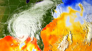
PETER STANDRING: NASA is using satellites to understand hurricanes both inside and out.
MARSHALL SHEPHERD: Twenty, thirty years ago, when we used a conventional view of a storm, we could really only see the cloud top. We could see how big the storm was, we could see the white mass which represented the clouds, and that was valuable, but that's all we could see. We were just touching the hood of the car. Now we can pop the hood and look inside the storm.
PETER STANDRING: To do that, they're using a satellite equipped with weather radar, the only one of its kind.
Much the way a CAT scan provides a three-dimensional picture of internal organs, the satellite's radar is producing stunning pictures of a hurricane's internal structure. And these unique images reveal something unexpected: extremely violent thunderstorms, called hot towers—seen here in red. These storms-within-a-storm can reach more than 10 miles into the sky.
MARSHALL SHEPHERD: When we see these hot towers, we think that they are giving us a clue that the storm is releasing a lot of energy, and it's firing on all cylinders if you will. And that may be a sign that the storm is about to undergo intensification processes.
PETER STANDRING: So you do think, preliminarily, that there's a link between the abundance of hot towers, and how strong and intense a storm is going to be?
MARSHALL SHEPHERD: That's exactly where we are in the research. We don't have enough evidence to conclusively link the number of hot towers or how tall they are to intensity, but our hypothesis is that they might be a sign or a clue that this hurricane is about to enter an intensification phase.
PETER STANDRING: And if this work pays off, forecasters will be able to predict more accurately not just where a storm will hit, but whether it will weaken or intensify just before landfall.
WALTER MAESTRI: What really scares me to death is that we get a category 2 or 3 hurricane that rapidly intensifies to a category 4 or 5 storm. That's the one that could absolutely be catastrophic here because we wouldn't get people out. People wouldn't be moving early as they were for Ivan. They would all be here, in the community, and all of a sudden we'd get this wall, this massive wall of water, the double whammy.
IVOR VAN HEERDEN: Every year that goes by, the probability of this killer storm occurring increases.
JEFF HALVERSON: It's inevitable that at some point, probably in the next 10 to 15 years, there's going to be a tragedy somewhere along the U.S. coastline. It may not be New Orleans... some other high population center. Fairly likely scenario.
PETER STANDRING: Gaining a deeper understanding of hurricanes is the best answer, but it won't happen overnight.
Here on Bourbon Street, the good times continue to roll. But the party atmosphere masks a widespread concern about the threat of these killer storms. For this city, or any other place that's at risk, improvements in hurricane prediction can't come soon enough.
ROBERT KRULWICH: Correspondent Peter Standring.
Credits
Hurricanes
PBS Airdate: January 25, 2005
- Edited by
- Jonathan Sahula
- Written, Produced, and Directed by
- Joseph McMaster
NOVA scienceNOW Credits
- Executive Producer
- Samuel Fine
- Executive Editor
- Robert Krulwich
- Senior Series Producer
- Vincent Liota
- Supervising Producer
- Andrea Cross
- Development Producer
- Kyla Dunn
- Associate Producer
- Win Rosenfeld
- Program Editor
- Jonathan Sahula
- Unit Manager
- Candace White
- Researcher
- Jason Spingarn-Koff
- Production Secretary
- Hong Jung
- Music
- Rob Morsberger
- NOVA scienceNOW series animation
- Edgeworx
- Animation
- Sputnik
- Associate Producers
- Anthony Manupelli
Stephanie Mills
Mary Robertson - Production Assistant
- Robbie Gemmel
- Camera
- Daryl C. Pendana
Brian Dowley
Allen Facemire
Robert Hanna
Robert Jaye
Tom Kaufman
Sam Painter
Rick Robertson
Ken Willinger - Sound
- Michael Boyle
Doug Donald
Bob Freeman
Don Hale
Daryl C. Pendana
Percy Urgena
Hans Vandenbold - Archival Material
- ABC News Video Source
CNN Image Source
Corbis Corporation
The Image Bank by Getty Images
NASA Goddard Space Flight Center
Prairie Pictures/Stormstock
SSEC, University of Wisconsin-Madison
TRAC/CALLAIS COMMUNICATIONS/WLAE TV
World Wrestling Entertainment, Inc.
Three-dimensional animation courtesy of LONI and the Center for Computational Biology in collaboration with the National Institutes of Mental Health. Principal Investigator: Arthur W. Toga, Animators: Ken Nakada, Tomokatsu Shoji, Hideo Kumagai, Amanda Hammond, Kim Hager, Andrew Lee & John Bacheller
- Special Thanks
- Ahmanson Lovelace Brain Mapping Center
Blondies Sports Bar on the East Side NYC
David Geffen School of Medicine at UCLA
Ross Hoffman
Alfred Naomi
National Primate Research Center at University of Wisconsin
Oregon Primate Research Center
Harlan Reiniger
Resonance Technology
Naomi Surgi
Walter Williams
Adam Zoghlin - Audio Mix
- John Jenkins
- NOVA Series Graphics
- yU + co.
- NOVA Theme MUSIC
- Walter Werzowa
John Luker
Musikvergnuegen, Inc. - Additional NOVA Theme Music
- Ray Loring
- Post Production Online Editor
- Spencer Gentry
- Closed Captioning
- The Caption Center
- NOVA Administrator
- Dara Bourne
- Publicity
- Jonathan Renes
Diane Buxton
Olivia Wong - Senior Researcher
- Barbara Moran
- Production Coordinator
- Linda Callahan
- Unit Manager
- Lola Norman-Salako
- Legal Counsel
- Susan Rosen Shishko
- Post Production Assistant
- Patrick Carey
- Associate Producer, Post Production
- Nathan Gunner
- Post Production Supervisor
- Regina O'Toole
- Post Production Editor
- Rebecca Nieto
- Post Production Manager
- Maureen Barden Lynch
- Supervising Producer
- Stephen Sweigart
- Producer, Special Projects
- Susanne Simpson
- Coordinating Producer
- Laurie Cahalane
- Senior Science Editor
- Evan Hadingham
- Senior Series Producer
- Melanie Wallace
- Managing Director
- Alan Ritsko
- Senior Executive Producer
- Paula S. Apsell
NOVA scienceNOW is a trademark of the WGBH Educational Foundation
This material is based upon work supported by the National Science Foundation under Grant No. 0229297. Any opinions, findings, and conclusions or recommendations expressed in this material are those of the author(s) and do not necessarily reflect the views of the National Science Foundation.
NOVA scienceNOW is produced for WGBH/Boston by NOVA.
© 2005 WGBH Educational Foundation
All rights reserved
Sources
Links
National Hurricane Center
www.nhc.noaa.gov/
This site tracks active tropical cyclones in the Atlantic, Caribbean, and Eastern Pacific during the hurricane season, with satellite images updated every hour and much more useful information, including e-mail advisories and notes on hurricane preparedness.
NOAA's Hurricane Research Division
www.aoml.noaa.gov/hrd/
Part of the Atlantic Oceanographic and Meteorological Laboratory, which conducts research on hurricanes, this site has a very rich FAQ section. Answered questions range from why are tropical cyclones named to why don't we try to destroy tropical cyclones?
EYE TO EYE: Seeing Hurricanes As Only NASA Can
www.nasa.gov/centers/goddard/news/topstory/2004/0915isabel/addl.html
This extremely rich page offers in-depth analysis of Isabel, Frances, and other 2004 hurricanes. The page offers numerous intriguing QuickTime movies and animations built from data and images of hurricanes captured by NASA and NOAA satellites.
Related Links
-

Inside the Megastorm
Watch as Megastorm Sandy unfolds, and explore what made it so much more devastating than other hurricanes.
-
Storm That Drowned a City
Experts and eyewitnesses reconstruct the devastating floods that Hurricane Katrina unleashed on New Orleans.
-
Stronger Hurricanes
Is global warming making hurricanes more intense?
-
Hurricane Power
Your average hurricane releases enough energy to power the world 200 times over. Go figure.