
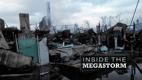
Inside the Megastorm
Watch as Megastorm Sandy unfolds, and explore what made it so much more devastating than other hurricanes. Airing October 2, 2013 at 9 pm on PBS Aired October 2, 2013 on PBS
- Originally aired 11.18.12
Program Description
Transcript
Inside the Megastorm
PBS Airdate: November 18, 2012
NARRATOR: Anatomy of a catastrophe...
BROAD CHANNEL FIRE DEPARTMENT TRUCK LOUDSPEAKER: The mayor of the city of NY has ordered a mandatory evacuation.
NARRATOR: â¦superstorm Sandy slams the northeast...
Man's voice: â¦huge storm surge. Oh, my gosh.
MARTY INGRAM (Breezy Point Volunteer Fire Department): And the water never stopped coming.
ARIEL FAHY (Breezy Point Resident): It came down and it just washed everything away.
NARRATOR: â¦dozens dead, tens of thousands homeless, entire communities obliterated.
ARIEL FAHY: The entire sky was just lit up.
GUY FERRARO (Union Beach, New Jersey Resident): â¦like a bomb went off.
NARRATOR: Are lethal storms becoming more frequent, more destructive, even more deadly?
ALEXANDER "SANDY" MACDONALD (National Oceanic and Atmospheric Administration, Earth System Research Laboratory): It really was a combination of the worst that nature delivers in storms.
NARRATOR: Stormchasers take you inside the eye of Hurricane Sandy, for a blow-by-blow account of an epic natural disaster.
JEFF WEBER (University Corporation for Atmospheric Research): So it came in right at high tide, during a full moon, record storm surge, with incredible winds.
NARRATOR: How vulnerable are the most populated cities?
JOHN MIKSAD (Consolidated Edison Company of New York): So there are parts of Manhattan that were being impacted 25 feet above sea level.
NARRATOR: Can we engineer our way to safety, if Sandy is a sign of things to come? Inside the Megastorm, a special presentation, right now, on NOVA.
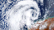
In the warm waters of the Caribbean, a tropical storm is forming, one that is about to write its way into the history books. It's the 18th storm of the Atlantic season. The National Weather Service assigns a name from near the bottom of this year's predetermined list, an innocent-sounding label for what will soon become, against all odds, a devastating megastorm: Sandy. It's October 22, 2012MATT LAUER (Today/Film Clip): Let's start then with the latest from Al and this tropical storm Sandy. Al, good morning.
AL ROKER (Today/Film Clip): That's right. All eyes right now in the Caribbean, Matt. Sandy is 120 miles, 120 miles south of Kingston, Jamaica, 70 miles per hour winds; just not quite a hurricane yet.
NARRATOR: Tropical storms are a fact of life in the Caribbean, but only about half strengthen into hurricanes.
JEFF WEBER: Hurricanes are systems that are born in the tropics, and they need to have 26 degrees Celsius, approximately 80 degrees Fahrenheit, water to get the systems going. They actually act as a heat engine. They take the warm water, and it rises up as water vapor. And as that water vapor condenses, it releases latent heat into the atmosphere, and that's where the wind energy is coming from.
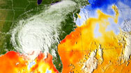
NARRATOR: Only one in 20 Atlantic hurricanes ever strikes the east coast. Odds are that Sandy will do what virtually all of these hurricanes do, head into the Gulf of Mexico, like Katrina, or blow into the cold Atlantic and fade harmlessly away. But then, a startling prediction from 4,000 miles away upends all expectations. A day even before Sandy has been named, the supercomputers at a European weather center predict that she will not follow the normal course.
TIM HEWSON (European Centre for Medium-Range Weather Forecasts): Conventional wisdom said that Sandy would move towards the north, 'cause it was in the Caribbean, and then towards the northeast, and then it would die and not affect land. But there were suggestions that that the hurricane might not behave in a normal way and might actually end up over the northeast of the U.S.
NARRATOR: Worse than that, the model goes on to predict that once Sandy reaches the northeast, it will make a sudden, improbable left turn, sending it straight into the heart of the Jersey shore and New York City.
SANDY MACDONALD: When the European Centre model came out, eight days before, I think the reaction was, "This is a really dangerous possibility, but it's so far in advance, we're going to just have to watch this."
NARRATOR: Now, late in October, with the hurricane season drawing to a close, New Yorkers are preparing Halloween parties, not thinking about a storm. But that's about to change, because the storm with the innocent name is about to ring their doorbell, dressed as a monster.
A thousand miles to the south, Sandy is becoming a storm to be reckoned with. Since her birth, as a tropical depression, she has steadily gathered energy, fed by the warm tropical waters. On October 25th, she is officially upgraded to a Category 2 hurricane, with sustained wind speeds of more than 110 miles per hour. She has already brought devastating winds and fierce rains to Haiti and Jamaica, and now heads north to Cuba and beyond. At this point, computer models at N.O.A.A., the National Oceanic and Atmospheric Administration, are still showing several possible paths.ADAM SOBEL (Columbia University): The American model, like all these models, was run in an ensemble mode, where the models run many times each day. And as late as Wednesday or Thursday, the 24th or 25th, the American model had some tracks coming in and making landfall, but other tracks going out to sea. And by about Thursday or Friday, the American model started to agree more with the European models. And we became quite confident that Sandy would make the left turn and come into the mid-Atlantic region.
NARRATOR: Now, all the models are converging, forecasting that Sandy will swing sharply around from its northeast track and crash into New York and New Jersey and much of the east coast. Parts of the coastlines of New York and New Jersey are only a few feet above sea level. Strong winds could push the ocean right onto the land, causing extensive flooding.
ADAM SOBEL: And it was quite clear that there was a possibility of a very high storm surge, and that it could be a catastrophic event.
NARRATOR: The city's emergency services, police, fire and hospitals, begin to prepare for the worst.
SALVATORE CASSANO (New York City Fire Commissioner): We started on the Thursday before the storm hit. People were checking their equipment, checking their pumps, making sure our boats were in order, all the prep you would do for a storm.
NARRATOR: But despite all the warnings, there remain plenty of doubters.
MICHAEL CLARKE (Staten Island Resident): We thought they were just amping it more than what it was, to cover themselves, basically.
LINDA CLARKE (Staten Island Resident): We said, "Oh, yeah, here comes another storm."
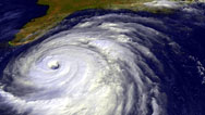
NARRATOR: Sandy heads north out of the Caribbean, leaving more than 70 dead and dozens missing. It is a massive system, sending tropical-storm-force winds across an area nearly 600 miles wide. Now, the first of many unusual meteorological conditions begin to affect the storm's path.
JEFF WEBER: There's a high-pressure system that kind of lives over Bermuda. It's called the "Bermuda high." And, generally speaking, Atlantic systems will kind of come along the bottom side of that high and then kind of curve around it and move its way back out into the eastern Atlantic.
NARRATOR: But this time, there's no Bermudan high to steer Sandy away from land, so the storm heads to the northeast, parallel to the eastern seaboard.
Though most of the ocean gets colder, Sandy feeds off a ribbon of warm water that keeps it alive: the Gulf Stream, a circulating current that pumps warm water from the Gulf of Mexico up and across the Atlantic. And right now, the surface waters are even warmer than usual.
RADLEY HORTON (Center for Climate Systems Research): Parts of the North Atlantic were five degrees warmer than normal. And you could see, as you watch those satellite images, as Sandy passed over that unusually warm water, it increased in strength. You could see new convection, new thunderstorms forming.
NARRATOR: Though Sandy is still more than 200 miles off the U.S. coast, storm-force waves and winds have been pounding Florida and North Carolina, knocking out highways.
At 5 a.m., on Sunday, NOAA meteorologist Dr. Alexander "Sandy" MacDonald flies NOAA's P3 Orion right into the heart of the hurricane, in order to get a firsthand look at the anatomy of the growing storm.SANDY MACDONALD: We take a lot of measurements that allow us to determine what the hurricane is going to do. Is it going to intensify? Where is it going to go.
NARRATOR: When the answers start to emerge, the news is not good. Sandy is undergoing a dangerous transformation.
JEFF WEBER: Sandy is rolling up the eastern seaboard, feeding off of the gulfstream waters. As we roll into the 28th of October, Sandy is starting to expand and lose its tropical characteristics.
NARRATOR: As they move north into cooler waters, most hurricanes begin to fade, but since these waters are warmer than normal, Sandy doesn't flag. Even worse, flying through the heart of the hurricane, Doctor MacDonald sees something shocking: Sandy is actually growing in size, with the help of a second storm.
SANDY MACDONALD: It had been a fairly normal Category 1 hurricane, but as it came north, there was what we call a "nor'easter.
NARRATOR: The nor'easter is a winter storm that has been developing inland, parallel to Sandy's track north.
SANDY MACDONALD: A nor'easter can be 500 or 700 miles across.
NARRATOR: From his vantage point inside the hurricane, Doctor MacDonald can see the two storms morphing into a hybrid, a superstorm.
SANDY MACDONALD: It had the big size, the huge rains, and right in the center of it, it had those super-strong winds and super-low pressure. It really was a combination of the worst that nature delivers in storms: two put together.
NARRATOR: Sandy is no longer a hurricane that can fade and die as the water temperature falls. It's become too big and powerful. Now, with Halloween just days away, news services have given Sandy a new name: "Frankenstorm.
CHARLIE ROSE (CBS Morning News/Film Clip): Forecasters have found a new word to describe the potential impact of Hurricane Sandy on the east coast. They're calling it, "Frankenstorm."
NARRATOR: In New York, full-scale preparations are underway for a major hurricane hit.
SALVATORE CASSANO: Sunday morning we were on a conference call with the National Weather Service at the National Hurricane Center. The tone of the report they gave us on Sunday morningâ¦we sort of started to realize this was going to be as bad a storm as they had predicted all along.
BROAD CHANNEL FIRE DEPARTMENT TRUCK LOUDSPEAKER: The Mayor of the City of New York has ordered a mandatory evacuation of the island of Broad Channel
NARRATOR: Officials in both New York and New Jersey order a mandatory evacuation of flood-prone areas, but not everyone is prepared to heed the warning. And many know just what to blame for that: Hurricane Irene.
In August, 2011, hurricane Irene hit New York. It was a powerful and destructive storm, but because it didn't inflict as much damage as predicted, it left New Yorkers skeptical.JEFF WEBER: I have family and friends in the New York and New Jersey area, and they were asking me, they said, you know, "Is this going to be like Irene? Because we were fine with Irene. We didn't have any problems with Irene." I had to respond to them saying "No, this is much bigger. This is going to have a far greater impact than Irene.
NARRATOR: For the skeptics, Irene holds out a false promise that city services like electric power could escape without disruption.
JOHN MIKSAD: Irene was sort of a dry run. Nothing, not the generation system, not the transmission system, not the substations nor the distribution system were impacted by floodwaters in Irene.
NARRATOR: But any hopes that the city would escape unscathed this time around are dashed when, at 7 p.m., the New York Transit Authority system begins to shut down. The city's lifeline, the subway, closes.
JOSEPH LHOTA (Chairman and Chief Executive Officer, New York City Metropolitan Transit Authority): It takes about 12 hours to completely shut down the New York City subway system. We did not want to bring everybody into New York City on Monday and strand them here, so that's why we proposed the beginning of a shutdown on the subway system on Sunday night, at seven o'clock, and all of our assets were tied up and locked up, by 3 a.m., Monday morning.
NARRATOR: Five-thousand-nine-hundred buses and 8,663 subway and rail cars are now parked. Two-thousand-forty-seven miles of track, above and below ground, are empty. Also within its complex network are 14 underwater subway tunnels, 14 tunnels into which, if the water pours, it doesn't come out. The city that never sleeps is closing up shop.
Sandy is now 425 miles from New York. The hybrid, two storms in one, spreads tropical-storm-force winds over more than a thousand miles, carrying the energy of five Hiroshima bombs. Still travelling parallel to the coast, it runs headlong into the most significant event in its seven-day life: a massive system of high pressure looming over the Atlantic.
ADAM SOBEL: A so-called "blocking high," or high pressure system, was forming out in the Atlantic around the southern end of Greenland, and those blocking highs prevent storms from making their way out to sea.
NARRATOR: But Sandy does not simply grind to a halt. High in the atmosphere are fast-moving winds, collectively called the jet stream, normally traveling west to east. But, in this case, the jet stream isn't following its normal west to east course. Disrupted by the high pressure system to the north and the winter storm, part of the jet stream turns back toward the west.
RADLEY HORTON: Most storms, as they get about as far north as New Jersey, especially this late in the hurricane season, are picked up by the jet stream and moved to the east. This storm, it became more and more clear, was going to take that turn to the west that would bring millions of people into harm's way.
NARRATOR: Early on October 29th, the forecasters' predictions come true. Sandy takes a sharp left. If there had been any doubt, it's gone by now. Sandy will slam into the east coast in a little more than 12 hours, right at high tide, the worst possible timing.
ADAM SOBEL: And at that point, my scientific fascinations started to mix with actual fear for the, for the fate of the, of the city and the surrounding areas.
JOHN MIKSAD: We were certainly in a heightened state of awareness. We had our emergency response center running, made sure that all the floodgates in our generating stations and substations were prepared. I would say "anxious" would probably be a good description of the, of the mood in here.
NARRATOR: Air traffic in and out of New York and New Jersey is grounded. Both states are now being battered by winds of 75 miles per hour. The New York Stock Exchange closes for the first time since 9/11. Even though the eye of the storm is still 260 miles from Atlantic City, 310 miles from New York, the Battery Promenade in lower Manhattan is already under water. The sea level is already three or four feet above normal.
RADLEY HORTON: Monday morning, a full 10 or 12 hours before the storm was forecast to make landfall, you were already seeing record-high flooding levels throughout the New York City region.
NARRATOR: It's the beginning of the powerful storm surge, driven by the unrelenting winds.
ADAM SOBEL: As the wind pushes on the water, if it pushes it towards the shore, then when the water gets close to the coast, where the, the bottom is shallow, the water level gets raised, and that's the storm surge. And that comes on top of whatever the tide is.
NARRATOR: The worry is that if Sandy strikes at high tide, the resulting storm surge will overwhelm the city—particularly lower Manhattan, parts of which are less than 10 feet above sea level—and do the same to a vast expanse of the New Jersey shore. At around 11 a.m., veteran stormchaser Scott McPartland heads towards the Bronx.
SCOTT MCPARTLAND (Stormchaser): Back up a bit. And I want to go on one of these side streets. We should go to another vantage point. Try to get down there.
(Stormchaser Camera Operator): And shoot this way.
SCOTT MCPARTLAND: Yeah, yeah, yeah.
Well, we first left the house about eleven o'clock in the morning, on Monday, the day of the storm, and we travelled right up to Whitestone, Queens, right at the foot of the Bronx Whitestone Bridge. When we got there, the water was already pouring over the seawall. It was inundating neighborhoods. It was already in people's backyards, already in people's homes, at this point. When I saw this taking place, and it was still so early in the day, and we knew that the worst of the storm was still many hours away, that's when it really started to set in that this storm was really going to be as bad as everybody said it was going to be.NARRATOR: Exactly as predicted, as Sandy gets closer to land, it absorbs energy from the high-altitude wind of the jet stream.
JEFF WEBER: And so it went from 18 miles an hour to about 28 to 30 miles an hour. That speed increase will increase the surge, increase the waves, increase the wind and allow it to make faster progress inland.
NARRATOR: Within the storm, wind speeds rise to over 90 miles per hour, as Sandy accelerates. The monster drives a surge of water toward the New Jersey shore and the five boroughs of New York City. Scott is stationed in low-lying Queens at 4 p.m., with five hours to go before the peak of the storm. And even for him, the sudden influx of water is alarming.
SCOTT MCPARTLAND: The water, at this point, at Rockaway Beach, was already hitting the boardwalk. The storm surge is winning already. It was the first time that I can remember that the ocean really scared me, seeing the water in that state. It was white water. You could feel the entire boardwalk shaking as you're standing on it. At this point, there were still people, residents, wandering on the boardwalk, walking their dogs. I think at this point most people did understand how serious this was, but there still seemed to be a few that didn't get it.
NARRATOR: Rockaway, a low-lying area at the south end of Queens is within the evacuation zone. In late afternoon, things begin to go wrong for residents, like Shatisha Haywood
SHATISHA HAYWOOD (Far Rockaway Resident): The lights start to flicker on and off. Then they went off. They came back on, then they went off again. They came back on, and then, around 5:30, they were completely out, and it was dark.
NARRATOR: Her six children are frightened.
SHATISHA HAYWOOD: 'Cause it was just like, "Mom, the lights went off, turn the lights back on." And I'm like, "I can't turn the lights back on.
NARRATOR: Near Rockaway Beach is the Breezy Point neighborhood, perched on a narrow spit of land. The local volunteer fire crew has spent several days preparing to protect those who would not or could not leave.
MARTY INGRAM: We had purchased food, we had sleeping gear, our plan was to hunker down here and shelter in place and make sure the trucks' batteries, the water, gas, everything was at prime.
NARRATOR: But despite their best efforts, Breezy Point is about to become one of the worst hit casualties of Sandy's fury, when the storm surge submerges the entire town.
Man's voice: There it is, huge storm surge, everybody. Here we go. Oh, my gosh, here it comes: six inches of flood water.
MARTY INGRAM: At 5:30 the tidal surge came, and that was two-and-a-half to three hours before moon high tide. And the water never stopped coming.
ARIEL FAHY: When I tell youâ¦the storm hit, like, as fast, like a bolt of lightning. It came down, and it just washed everything away.
NARRATOR: As water floods the town, members of the fire department urge residents to retreat to the relative safety of the local community center, but soon that building also begins to flood.
MARTY INGRAM: We had a marble floor in there. It was bubbling up through the seams by the marble. And we were three hours away from high tide, and we knew we were in for a, for an interesting evening.
NARRATOR: All across New York City, the storm surge builds, amplified by an accident of geography.
MALCOLM BOWMAN (Stony Brook University, The State University of New York): Long Island Sound is shaped like a funnel. And winds push this water into western Long Island Sound, and that squirts through the East River into New York Harbor.
NARRATOR: The narrow waterway concentrates the waves that pound, not only Queens, but the harbor and especially Staten Island.
On Fox Beach Avenue, ex-Marine John Filipowicz and his son, John, Jr., have been feverishly working to protect their home. John, Sr.'s brother Neil was staying in touch by phone.NEIL FILIPOWICZ: I spoke to him in the afternoon, I had asked him, "Do you want me to come down?" He's like, "No, it's alright, I've got John here. I'll be okay.
He prepared his home for it. He not only sandbagged the door downstairs, he put expandable foam and tape around the creases in the door. There was no way the water was getting in.NARRATOR: But the nightmare was just beginning.
JEFF WEBER: People in New York City were experiencing hurricane force winds for eight hours or more. Hurricane Sandy had an expanse of about 1,000 miles. It was huge. It takes a long time to move 1,000 miles of weather across a city.
NARRATOR: On the Rockaways, the surge inundates the streets.
SHATISHA HAYWOOD: It got darker. The water started to rise, and my 14-year-old son, he came and he said, "Mom, the water is over Dad's car." So I'm like, "No, the water can't be over Dad's car." When I looked out the window, the water was over my husband's car.
You can hear people screaming, "Help!" It was like a nightmare, like a pitch-black movie, and they were just yelling, "Help!" You heard a young lady, and you heard a couple of male voices, and they were screaming, "Help!NARRATOR: With people struggling in the dark, power company technicians who have been anxiously monitoring their systems suddenly find the entire grid in peril.
JOHN MIKSAD: Around seven or eight o'clock, we got the word that they were being overcome and that the water was getting into the underground system.
NARRATOR: Most of Manhattan's transmission lines and many circuit breakers are located below ground. Saltwater and electricity are a dangerous mix. In order to prevent electrical fires, Con Ed makes a brutally tough call. The power company pulls the plug, plunging much of lower Manhattan, including Wall Street, into darkness.
Across the harbor, in the close-knit Staten Island community, conditions continue to deteriorate.
MICHAEL CLARKE: I stayed till about seven-thirty, eight o'clock; tried moving cars up a few blocks that way. By the time I came back here, to get dry clothes out of the house, the water was up to here on me.
It was like a tidal wave, boom.
NARRATOR: Michael Clarke's parents, Linda and Bob, live just around the corner. They don't want to abandon their home.
LINDA CLARKE: We have two dogs and a cat, and he saidâ¦oh, and chickens, he had two chickens, which I think he's worried about more than anything. But, uh...
BOB CLARKE (Staten Island Resident): Doing the backstroke.
LINDA CLARKE: He said, "Oh, I think we'll stay. I think we'll stay.
NARRATOR: By the time Linda finally decides to drive out on her own, it's too late.
LINDA CLARKE: I put the key in the ignition and I looked up and saw a wave of water coming around Cedar Grove Avenue. And I said, "Oh, my god," and I went to get out of the car, 'cause I realized it wasn't going to start, and the wave hit the car. And I had to push my way out of the car, because the water was coming in against the door. And I tried to make it to the back of the house, and the water was pushing me away. I was screaming, and Bob came running out, and he pulled me up, helped me get up the stairs. He pulled me out of the water, and we ran for the bedroom, because he said, "We have to get in the attic! We have to get in the attic!
NARRATOR: Linda and Bob are not the only residents fearing for their lives. Nine-one-one calls from Staten Island are flooding the fire department switchboard.
SALVATORE CASSANO: Just dealing alone with Staten Island would've been enough for the department, without everything else going on. So that was another point of concern for me in that Staten Island was really, really being, you know, wiped out. I live on Staten Island, so my family was there.
NARRATOR: But on higher ground, in parts of Brooklyn, Sandy feels like a bad storm, not a catastrophic killer.
MARCIA SIKOWITZ (Brooklyn Resident): I was listening to the news and hearing about what was coming to the areas on the shore and realizing this seemed like it was going to be a substantial storm, but I didn't have any real concerns for our safety or comfort in where we were, in Brooklyn.
NARRATOR: When Jake Sikowitz receives a call for help from a friend, he tells his mother, Marcia, he's going to brave the strong winds and rain.
MARCIA SIKOWITZ: When Jake said he was going out, and I knew they kept saying the peak of the storm would be in 40 minutes, I said, "Jake, I don't think this is a really good time to be going out." And he said, "Well, Jessie needs me to come over." And that was it. Jessie needed him, and he went.
NARRATOR: The storm is reaching its peak. Close to 8 p.m. on October 29th, the eye of the storm hits Atlantic City, New Jersey, bringing wind speeds of more than 80 miles an hour and waves higher than 40 feet.
JEFF WEBER: Once the eye makes its way onto land, that's the most intense part of the system. The eye wall is where all that energy and wind energy is at. Atlantic City suffered extreme damage: severe storm surge and monstrous flooding. And they also recorded the lowest pressure ever recorded in Atlantic City, at 940 millibars.
ATLANTIC CITY RESIDENT ONE (News Film Clip): This is worse than Katrina in size. This isâ¦we never went through anything like this.
ATLANTIC CITY RESIDENT TWO (News Film Clip): Thirty minutes, the water was up four feet, and just watching that water come up each step.
ATLANTIC CITY RESIDENT THREE (News Film Clip): ...unprecedented in my 20-year career in leadership in emergency management in this county.
GUY FERRARO: A wind came through here like I've never seen; sounded like a train coming. And I had, like, ten sliding doors, all in a line, in the back. They all just exploded from the wind, like a bomb went off. And then, minutes later, the whole roof went up in the air. It was like The Wizard of Oz.
There was ten feet of water all the way around me. There was just nowhere for me to go. So, after the roof blew off and then all the walls caved in, the floor went down into the basement, I swam to that car there, that you see, and got inside of it.NARRATOR: Throughout the region, people are finding themselves in life or death situations. In the Rockaways, Shatisha and her six children are trapped by floodwaters. She calls 911.
SHATISHA HAYWOOD: We got a voicemail, and it was saying, you know, "Everybody's call is important," you know? "Leave a message." But I wasn't leaving no message. This is 911, and I know 911 will pick up their phone. So I was able to get on Twitter, I was able to get on Twitter, and, you know, I tweeted and, you know, I was like, you know, "A, a huge shout out to the F.D.N.Y.
NARRATOR: At the fire department control center, Emily Rahimi runs social media.
EMILY RAHIMI (Social Media Manager, New York City Fire Department): I was prepared to be tweeting out safety information, and I started getting a lot of tweets from people who said they did not have phone service, that they would try calling 911 and they'd have them on their for a second, and then it would drop. A lot of them still had some connectivity, with their phones, to something like Twitter, and so that was just their way of reaching out, somehow, to get to somebody to help them.
NARRATOR: Shatisha's desperate tweet appears on Emily's screen.
EMILY RAHIMI: I remember she and her six boys were trapped in their house. Floodwaters were rushing in and she was really panicked. She didn't want to see her children in danger. And I knew I had to do something to help, so I started calling fire department dispatchers, to make sure that they had that information.
NARRATOR: At 8:30 p.m., the Hudson River breaches its banks and inundates the West Side Highway, in Manhattan. From there, it floods a critical electrical substation. Saltwater hits the cables carrying power to a quarter-million New Yorkers. The result is cataclysmic.
JOHN MIKSAD: With that explosion, 10 networks went simultaneously, which basically took out everything from 34th Street down to the Battery, almost half of this island
NARRATOR: Lower Manhattan goes dark.
MAN ON STREET (Flip Clip): You would never think this would happen in New York. So, the best way to deal with it now, is just not panic. People just got to stay civil.
NARRATOR: By now, 3,000,000 people in New York and New Jersey are without power. As bad as conditions are in lower Manhattan, the situation at Breezy Point is far worse. For a still-unknown reason, a house bursts into flame and fire quickly spreads.
ARIEL FAHY: The entire sky was just lit up in the reddest, orangest color, you could ever imagine. I called my mom and she, she was hysterical on the phone. She was like, "Just, just say a prayer." It was a very emotional time. I didn't know how I was going to get out.
NARRATOR: Meanwhile, the volunteer firemen are trapped by ever-rising floodwaters in their community center. They can do nothing, while their town burns.
Parts of New York and New Jersey are now under 14 feet of water or worse.JEFF WEBER: Now, keep in mind that on top of that storm surge you also have the wave action, and there were waves 10 to 15 feet high in this storm. So there were parts of Manhattan that were being impacted 25 feet above sea level.
NARRATOR: By now, the water coursing across lower Manhattan is pouring into the subway system. M.T.A. chief Joe Lhota is powerless to stop his beloved network from being overwhelmed.
JOSEPH LHOTA: This was worse than my worst fear. The water from the Hudson River was flowing down into the Battery tunnel; there were white rapids flowing into the tunnel, and it sounded like a waterfall. It ended up, the Brooklyn Battery Tunnel, each tunnel had 43-million gallons of water, over 6,000 feet, more than a mile, filled with water, floor to ceiling, side to side, completely filled up, all the way.
NARRATOR: At the fire department command post, calls for help continue to come in from every direction.
SALVATORE CASSANO: I've got a six-alarm fire in Breezy Point; I've got tons of people trapped in the water; I've got a fire on City Island; I've got people in Gerritsen Beach calling that they're trapped; I've got people in lower Manhattan that have no power.
NARRATOR: At 9 p.m., as the peak of the surge finally passes and the waters begin to recede, the Breezy Point firefighters manage to make their way back to their flooded station, where, at last, they catch a break.
MARTY INGRAM: Miraculously, even though these trucks were under water, they did start up. Once we started driving, the firemen stayed with the trucks and we started rescuing other people.
ARIEL FAHY: I saw the flashlight going back and forth. They were like, "The fire is coming this way. You need to get out of here. It's not safe anymore." When I finally got to the firehouse, my dad was up there, and he just saw me and grabbed me and didn't let go.
NARRATOR: In Rockaway, firefighters, alerted by her tweets, rescue Shatisha Haywood and her children. Her desperate husband finally manages to get through to her.
SHATISHA HAYWOOD: I said, "We're safe, we're fine. We're on a boat." And he was like, "A boat? What do you mean you're on a boat?" And we joke a lot, so he basically was like, "Shatisha, I'm really not playing with you at this time." So I kept saying to myself, I'm like, "Babe, I'm really not joking, like, I'm so serious. We're on a boat.
NARRATOR: In Ocean City, Guy Ferraro has been trapped in his flooded car for nearly five hours.
GUY FERRARO: You knew the tide was going out, and, by then, my legs were completely numb. I couldn't feel them at all. I was only in pajamas, at that point, at that point. I waited until I saw the police lights, and I knew that I couldn't stand the cold too much longer, and I knew I could get across that road. I was certain I could get across that road by that time. 'Cause it was just bedlam here: people screaming for hours and hours and hours for help, you know?
NARRATOR: The emergency services are now receiving 20,000 911 calls every hour. In Staten Island, Michael Clarke has heard nothing from his parents for hours. The water has made reaching them by foot or by car impossible.
MICHAEL CLARKE: I called my friend Brian. I said, "Brian, have you got a boat? Get something, do something. Get down here.
LINDA CLARKE: It was dark. We couldn't see anything. We had one little flashlight, and I kept saying to Bob, "Bob, is the water coming up more?" because I was afraid that it was going to come up so high and there was no way out of the attic. But he kept saying, "No, no, Linda, it's not coming up. It's not." I go, "Bob, I think it's going to come up, and we're going to drown.
MICHAEL CLARKE: I bang on my mother's door, and hearing their voices, it was like hitting the lottery. My mother looked at me and said, "What the hell are you doing here?" So...
LINDA CLARKE: I just started crying, hysterical, I just...
BOB CLARKE: I said, "You're nuts, Michael. What are you doing here?" He said, "I came to get you and Mom. You didn't call." I said, "How am I going to call, the phone's broke. I drowned it." That was that
MICHAEL CLARKE: I mean, what else could you do? It's something anybody would do for their parents, right?
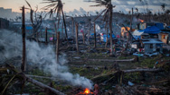
NARRATOR: Just before dawn, nearly 300 firefighters are finally able to converge on Breezy Point. But in the cruelest of ironies they discover that low pressure in the fire hydrants has left them desperately short of the one thing they need most: water. They stand by and watch as more than 100 houses burn to the ground.
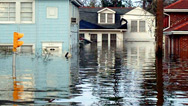
When the sun rises on Tuesday, October 30, large parts of New Jersey, New York and Long Island are like war zones, with damage extending up and down the eastern seaboard. The death toll will reach 200 people, which includes more than 70 who lost their lives in the Caribbean.REPORTER (NY1/Film Clip): When daylight came, the severe and widespread damage from Hurricane Sandy was painfully clear.
WOMAN ON STREET INTERVIEW (NY1/Film Clip): Nothing's going on. No traffic lights, no street lights. Just, there's cops everywhere. There's just debris and wetness everywhere.
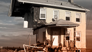
NARRATOR: Ships have been tossed onto land, houses driven from their foundations.
MAN ON STREET INTERVIEW (Film Clip): You can see the foundation right here. Here's the foundation. You can see everything under here, all the water, the pipes back up there.
NARRATOR: More than 8,000,000 people are without power. The Jersey shore, where, for decades, millions have enjoyed spending the summer, has been virtually wiped out. Eight counties have already been declared disaster areas. Fifty-thousand-five-hundred residents seek refuge in emergency shelters.
On Staten Island, Neil Filipowicz finally makes his way to Fox Beach Avenue. He's been trying unsuccessfully to reach his big brother, Flip, and nephew, John. They had chosen not to evacuate, in order to protect their home.NEIL FILIPOWICZ: I was going to yell at them for not calling anybody to let us know that he was okay. I was, I'm like, you know, here we are, everyone's trying to get in touch with him, phones aren't working, no one's answering, they're going right to voicemail.
NARRATOR: Across New York and New Jersey, landlines and mobile phone towers are down. So when he finally arrives, he's unprepared for the chilling scene before him.
NEIL FILIPOWICZ: The wall on one side was pushed in; all the cinder blocks were missing off the foundation. And I saw the water, and I said "Wow, this house got really destroyed," you know? I made my way down the basement, and it was completely pitch-black down there. I was calling him, but I didn't have a flashlight, and, like I said, it was completely dark.
NARRATOR: But there was no sign of his brother or nephew.
In Brooklyn, Marcia Sikowitz has also been searching for hours, trying to reach her son, Jake. Jake had never returned from going out to help his friend JessieMARCIA SIKOWITZ: I just started calling his cell phone every 15 minutes, which I knew didn't make a whole lot of sense, but I didn't know what else to do. And, finally, a man answered his phone, and I said, "Where's my son?" I thought maybe he had been mugged or, you know, why was this man answering his phone
I said, "Where is my son?" And he said, "What's your address?" And I said, "Where's my son?" And he said, "This is Detective Simon. Tell me your address. I am coming over to your apartment.NARRATOR: A short time later, five officers arrive, bearing the worst possible news. Jake and his best friend, Jessie, were killed by a falling tree at 7:45 the previous evening. The emergency services were so overwhelmed they hadn't reached their bodies for nearly 12 hours.
MARCIA SIKOWITZ: One of my neighbors said there was a disturbance in the force, you know, the force of goodness of Jake and Jesse. Somehow there was a disturbance, like, God looked away for a second and something terrible happened.
NARRATOR: Neil Filipowicz has still had no luck tracking down his brother and nephew. Neil returns to his brother's damaged home for another look.
NEIL FILIPOWICZ: Like I said, when I came in, I didn't get very far. And I panned from this way, here, around with the good flashlight that I had. I went to the left, and I saw, in this area, right here, a hand. And I was praying, "Please, let that be a doll's hand," you know? I reach in with my right hand, and I pulled up. And I could see my brother's face, and right behind it was my nephew's.
And they came up together, out of the water. And I see my brother had his other hand, his right hand, around his back, and my nephew was holding him around the waist, with his head buried like in his chest. And I can only think that they knew that they were going to die, and they just grabbed a hold of each other and, you know, to say, you know, "I've got you."NARRATOR: John left behind his wife, Christine, and their two surviving children.
At Breezy Point, residents estimate more than 100 homes have been consumed by fire. Debris and sand are everywhere. Yet, incredibly, not a single person has died, thanks, in part, to the heroic efforts of the local fire volunteers.MARTY INGRAM: Pulling up to the scene on the South Edge and seeing the flames just in the sky and then walking into the fireâ¦that, that, that memory will never leave. And seeing my men, you know, just unrestrained and motivated, without any fear and so dedicated to others and not themselves, it's so, so outstanding. I'm so proud of them.
NARRATOR: Transportion infrastructure has been crippled. Seven subway tunnels are flooded to the roof; six bus garages are under water.
JOSEPH LHOTA: We didn't know, at that point. We had no idea of the severity of the situation. We knew it was bad, we just didn't know how bad it was.
NARRATOR: The Army Corps of Engineers is called in, to help the city pump hundreds of millions of gallons of water. Engineers set out to assess the severity of damage caused by the corrosive saltwater.
MATTHEW ALBANESE (New York City Metropolitan Transit Authority): You have to understand, saltwater is brine, it eats up everything. All the signal equipment is going to have to be taken out, dried, tested. The wires that were on the side of the tunnel walls and whatnot just cooked. I mean all that you saw was bare copper when you came down here. You had that smell of diesel fuel, human waste, everything. It was like a cornucopia of rotten smells.
NARRATOR: Saltwater has destroyed parts of the electric grid, making repair work unusually hazardous.
JOHN MIKSAD: It's dangerous work on a blue sky day. I mean, these folks are working with high voltage, high pressure, high temperature, heavy machinery. It is, it is dangerous work on any day. When you have these hazards that have superimposed on the routine hazards, it is just, it can be a very dangerous combination.
NARRATOR: It will take days for Con Ed crews to bring power back to the city. Some places will be without electric power for weeks. However, the stock exchanges manage to open two days after Sandy, thanks to emergency generators.
Not just the city, but the entire region is reeling. It's getting cold, and many homes have no heat. Food deliveries are a problem, and gasoline will have to be rationed. Subway engineers work around the clock to restore service.JOSEPH LHOTA: The subway system is relatively simple: staircase, hole in the ground, another staircase. And it just keeps going and going, so we can make the city as mobile, and move everyone around as quickly as we possibly can.
NARRATOR: Finally, on Friday, fully four days after the storm, Con Ed turns on the lights in lower Manhattan. Life begins to return to normal. But harder hit areas, like the New Jersey shore and Staten Island will take far longer to recover.
Still, the city and the world begin to ask, "What's next? Was this truly a once-in-a-100-year storm, or is it the beginning of things to come? Did global warming influence the path or severity of this nearly unprecedented storm? Experts agree that Sandy followed a highly unusual track. Typically, the powerful jet stream pushes hurricanes eastward and out to sea. But Sandy turned hard left and headed west, into the most densely populated region of the continent. One obvious culprit was a strong high pressure system over the Atlantic, associated with a disturbed and wavy jet stream.RADLEY HORTON: With a wavier jet stream, it's easier for a storm to stagnate or even turn towards the west, towards the coast, which is what happened with Sandy.
NARRATOR: The shape of the jet stream is influenced by the temperature difference between the warm atmosphere at the earth's equator and the cold air at the North Pole. But Arctic temperatures have been rising twice as fast as temperatures over the rest of the globe, and some recent studies have found an association between a wavier jet stream and those rising temperatures.
So did a warmer Arctic set the stage for Sandy to turn? Most scientists say it's too soon to know for sure.RADLEY HORTON: What we can say, though, is that there's a lot of evidence suggesting if you remove ice from the Arctic, you see a wavier jet stream of the type that makes it easier for weather systems like Sandy to turn towards the west, instead of getting deflected towards the east.
NARRATOR: Right now, we can't blame Sandy's fateful turn directly on global warming. And neither is it clear whether global warming is affecting the frequency of these destructive storms. As some models show, any relationship between global warming and hurricanes is complicated.
ADAM SOBEL: And in those models, what happens as the climate warms is that the number of hurricanes actually is more likely to decrease than increase. But at the same time, the hurricanes that there are became more intense. So, right now, our, our models are predicting that hurricanes in a warmer climate will become fewer but more intense.
NARRATOR: But there is one undeniable factor that does relate directly to global warming and contributed to Sandy's destructiveness: sea level. The water in the ocean is warmer than it used to be, and warm water takes up more volume. Warmer seas are higher seas. Add to this melting ice at the poles.
ADAM SOBEL: What we do know is that, as the climate warms, the sea level will rise. It's already risen around a foot in the last hundred years, in the New York area. We don't know exactly how fast the sea level will rise, but we know for certain that it will rise. It could be as much as several feet in the next century.
NARRATOR: And that means, decades from now, a storm like Sandy would be even more devastating.
RADLEY HORTON: As you raise those average sea levels, it's like raising the floor of a basketball court. If you don't change the height of the rims, you're going to get more slam dunks, just because that average sea level has gotten higher.
NARRATOR: This will force coastal cities all over the world to consider hardening their infrastructure: transportation, electrical and emergency services, and possibly to spend billions of dollars on protective barriers like storm gates.
RADLEY HORTON: I think that Sandy was a huge wakeup call, not just for New York City, but for the U.S. Sea levels are rising; we're going to see more coastal flood events in the future.
NARRATOR: For those who survived this storm, that cannot be welcome news.
MICHAEL CLARKE: I tell you right now, even before this, my outlook on it: Mother Nature rules. There's one thing I just don't want to screw with: the water. Water, wind, it all rules over us.
LINDA CLARKE: I don't know if we could go through what we just went through again. It is enough for a lifetime. I see that wave coming around the corner every night when I go to sleep. It's just not a good feeling.
NARRATOR: As time passes, hurricane names get re-used, except for those whose deadly legacy is carved into the history books. There will never be another hurricane named "Sandy."
Broadcast Credits
- EXECUTIVE PRODUCERS FOR NOVA
- Chris Schmidt
Julia Cort - FIELD PRODUCER
- Vincent Liota
- SENIOR SCIENCE EDITOR
- Evan Hadingham
- SENIOR RESEARCHER
- Kate Becker
- POST PRODUCTION MANAGER
- Nathan Gunner
- POST PRODUCTION EDITOR
- Rebecca Nieto
- SENIOR DIGITAL EDITOR
- Tim De Chant
- NARRATED BY
- Corey Johnson
- EXECUTIVE PRODUCERS FOR DRAGONFLY FILM AND TELEVISION
- Dan Gold
Tamara Abood
Simon Dickson - PRODUCED AND DIRECTED BY
- Talya Tibbon
Jo Locke - EDIT PRODUCER
- Tom Pearson
- EDITED BY
- Erick Henson
John Moffat
Mark Summers - CAMERA
- Mark Molesworth
Patrick Duval
Ross Keith
Scott Sinkler
Gary Henoch
Mark Gunning - SOUND RECORDISTS
- Dennis Herbeck
Geoff Price
Merce Williams
James Anderson
David Manahan - 2ND UNIT DIRECTORS
- Toby Oppenheimer
- 2ND UNIT ASSISTANT DIRECTOR
- Michael Reichman
- CONSULTANT
- Ali Turner
- PRODUCTION EXECUTIVE
- Claire Wingate
- LINE PRODUCER
- Amanda Hibbitts
- ADDITIONAL PRODUCERS
- Liz Biggs
Emma Love
Minna Sedmakov
Jess Watts - LOCATION PRODUCERS
- Kari Pricher
Linda Zecchino - PRODUCTION COORDINATOR
- Sally Finigan
- PRODUCTION TEAM
- Sian Atkinson
Joseph Burden
Donna Higgins - RESEARCH
- Imogen Ogilvie
Hannah Shrives - ARCHIVE TEAM
- Nick Gilbert
Beatrice Read
David Studwell - ARCHIVAL MATERIAL
- Clark Evans, University of Wisconsin-Milwaukee
Scott McPartland
George Kourounis
NYPD
Storm Stock
National Guard
NASA-GSFC
MTA
New York Times
Getty Images
Casey Neistat
NOAA
NOAA-AOC
Jeff Piotrowski
ITN Source
Pond5
ConEdison
NYSE
AP Archive
FDNY
Videoplugger
US Military DVIDS - SPECIAL THANKS
- Unidata Program Center, UCAR
- BUSINESS AFFAIRS
- Iain Walmsley
- TALENT EXECUTIVE
- Elsa Sharp
- ACCOUNTANT
- Sonia Jean-Louis
- ANIMATION
- Fluid Pictures
- ONLINE EDITOR
- David McSkimming
- COLORIST
- Toby Tomkins
- AUDIO MIX
- Dominic Weaver
- POST PRODUCTION ONLINE EDITOR
- D'Arcy Maclean
- NOVA SERIES GRAPHICS
- yU + co.
- NOVA THEME MUSIC
- Walter Werzowa
John Luker
Musikvergnuegen, Inc. - ADDITIONAL NOVA THEME MUSIC
- Ray Loring
Rob Morsberger - CLOSED CAPTIONING
- The Caption Center
- MARKETING AND PUBLICITY
- Karen Laverty
- PUBLICITY
- Eileen Campion
Victoria Louie - NOVA ADMINISTRATOR
- Kristen Sommerhalter
- PRODUCTION COORDINATOR
- Linda Callahan
- PARALEGAL
- Sarah Erlandson
- TALENT RELATIONS
- Scott Kardel, Esq.
Janice Flood - LEGAL COUNSEL
- Susan Rosen
- DIRECTOR OF EDUCATION
- Rachel Connolly
- DIGITAL PROJECTS MANAGER
- Kristine Allington
- DIRECTOR OF NEW MEDIA
- Lauren Aguirre
- POST PRODUCTION ASSISTANT
- Brittany Flynn
- COMPLIANCE MANAGER
- Linzy Emery
- BUSINESS MANAGER
- Elizabeth Benjes
- DEVELOPMENT PRODUCER
- David Condon
- PROJECT DIRECTOR
- Pamela Rosenstein
- COORDINATING PRODUCER
- Laurie Cahalane
- SENIOR SERIES PRODUCER
- Melanie Wallace
- MANAGING DIRECTOR
- Alan Ritsko
- SENIOR EXECUTIVE PRODUCER
- Paula S. Apsell
Produced by Dragonfly Film and Television Productions Ltd for NOVA/WGBH in association with the BBC
© 2012 Dragonfly Film and Television Productions Ltd and WGBH Educational Foundation. All rights reserved.
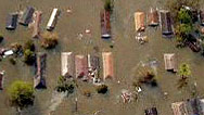
IMAGE
- (Sandy aftermath)
- © Andrew Lichtenstein/Corbis
Participants
- Matthew Albanese
- New York City MTA
- Malcolm Bowman
- SUNY Stony Brook
- Salvatore Cassano
- New York City Fire Commissioner
- Linda Clarke
- Staten Island Resident
- Michael Clarke
- Staten Island Resident
- Robert Clarke
- Staten Island Resident
- Ariel Fahy
- Breezy Point Resident
- Guy Ferraro
- Union Beach, NJ Resident
- Neil Filipowicz
- Staten Island Resident
- Shatisha Haywood
- Far Rockaway Resident
- Tim Hewson
- European Center for Medium-Range Weather Forecasts (ECMWF)
- Radley Horton
- Center for Climate Systems Research
- Marty Ingram
- Point Breeze Volunteer Fire Dept.
- Joseph Lhota
- Chairman & CEO, NYC MTA
- Sandy MacDonald
- NOAA Earth System Research Lab
- Scott McPartland
- Stormchaser
- John Miksad
- Con Edison
- Emily Rahimi
- Social Media Manager, FDNY
- Marcia Sikowitz
- Brooklyn Resident
- Adam Sobel
- Columbia University
- Jeff Weber
- University Corporation for Atmospheric Research
Preview | 00:30
Full Program | 53:37
Full program available for streaming through
Watch Online
Full program available
Soon

Related Links
-
Megastorm Aftermath
How can cities prepare for rising seas and raging storms?
-

Storm Surges and New York City
How multiple lines of defense, from massive barriers to oyster reefs, can protect our cities from storm surges.
-

Forecast for the Floodplains
Urban development coupled with intense hurricanes is causing storm damage to ripple beyond the coastline.
-

Climate Change and Sandy
A climate scientist suggests that rapid warming in the Arctic helped create October's "superstorm."
-

Sandy's Warning
Do we have what it takes to stop catastrophic warming?
-

Hurricanes and Climate Change
Why climate change is making hurricanes more dangerous.
-
Killer Typhoon
What made Haiyan so destructive, and how can we prepare for the next monster storm?
-
Stronger Hurricanes
Is global warming making hurricanes more intense?
-
Quiz: Hurricanes
Five questions that will separate the hurricane know-it-alls from the rest of us
-

Dispatch: Hurricane Katrina
Louisiana-based hurricane expert Ivor Van Heerden shares his agonized response to the disaster he'd long predicted.
-

Hurricane Katrina: Expert Q&A
Research meteorologist Marshall Shepherd answers questions about hurricanes and the ongoing threat to New Orleans.
-

For Forecasts, Follow the Fish
Discover how animals are deepening our understanding of the oceans and sharpening the accuracy of weather forecasts.
-
Anatomy of Katrina
Track the hurricane from its birth in the open ocean through its catastrophic encounter with the Gulf Coast.
-

How New Orleans Flooded
Examine a chronology of exactly where and how 85 percent of the city wound up underwater following Hurricane Katrina.
-
Hurricane Power
Your average hurricane releases enough energy to power the world 200 times over. Go figure.
-

The Secret Life of Gavin Schmidt
Climate scientist Gavin Schmidt has a passion for juggling, unicycling, and circus tricks of all sorts.
-
Storm That Drowned a City
Experts and eyewitnesses reconstruct the devastating floods that Hurricane Katrina unleashed on New Orleans.
-
Calling Katrina
Jonah Lehrer discusses new research into hurricanes that may help explain Katrina's devastating impact.
-

Recovering From Typhoon Haiyan
After the disaster, recovery in the Philippines will involve more than just distributing food and water.
-

Hotter Oceans, Fiercer Storms
In this audio slide show, examine the link between rising sea surface temperature and more intense storms.
-

Better Forecasts with Drones
How tropical cyclones intensify remains a mystery, but unmanned aerial vehicles could fill critical gaps in the data.
Additional funding for "Inside the Megastorm" is provided by Millicent Bell, through the Millicent and Eugene Bell Foundation.


National corporate funding for NOVA is provided by Draper. Major funding for NOVA is provided by the David H. Koch Fund for Science, the Corporation for Public Broadcasting, and PBS viewers.