
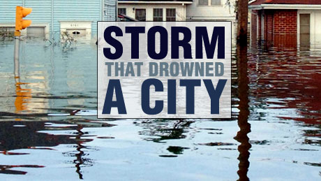
Storm That Drowned a City
Experts and eyewitnesses reconstruct the devastating floods that Hurricane Katrina unleashed on New Orleans. Airing November 22, 2005 at 9 pm on PBS Aired November 22, 2005 on PBS
Program Description
Transcript
Storm That Drowned a City
PBS Airdate: November 22, 2005
NARRATOR: Her name is all too familiar: Katrina, the storm that ravaged New Orleans.
BILLY GOMILLION (Louisiana Department of Wildlife and Fisheries): You always hear about the Doomsday storm. Well, this was it.
NARRATOR: She left in her wake around 1,300 dead, hundreds of thousands homeless and one of the most vibrant cities in America drowning and nearly destroyed.
WALTER MAESTRI (Emergency Director, Jefferson Parish): Wherever she went, she was going to have an impact. This was a large, powerful hurricane.
NARRATOR: In Katrina's wake, there are also questions. With improved hurricane forecasts, was the storm a predictable disaster? Who knew?
IVOR VAN HEERDEN (Louisiana State University): We were pretty convinced that it was just a matter of time.
WALTER MAESTRI: I knew I was right. I knew that it could happen.
NARRATOR: And who refused to listen?
IVOR VAN HEERDEN: We had a number of officials who basically scoffed at us.
NARRATOR: Almost surrounded by water, the city is protected by levees and walls. Were these overwhelmed by an unprecedented storm or simply not up to the job?
JOE SUHAYDA (Coastal Oceanographer): The concrete structure was pushed laterally, like the blade of a bulldozer.
BILLY GOMILLION: Who would ever think the levees would fail? It's something I never, in my wildest dreams, thought I would ever see or could ever happen.
NARRATOR: With more violent hurricanes predicted, is Katrina a taste of what's in store for the future?
PETER WEBSTER (Georgia Institute of Technology): This season has taught us that we had better be ready for intense storms.
NARRATOR: We can protect ourselves, but only if we understand. The Storm that Drowned a City, up next on NOVA.
NARRATOR: It looks like an ordinary day in New Orleans. The city is just awakening, and it's business as usual. Africa Brumfield, a resident of the 6th Ward, is up for an early morning walk; Walter Maestri, an emergency manager, is on his way to his office at Jefferson Parish; on the Gulf coast, northeast of the city, Lisa Monti has dropped in at her neighbors. Things seem calm, but there's trouble looming.
At the National Hurricane Center in Florida, the meteorologists are busy. It's hurricane season, and there's a storm called Katrina approaching with New Orleans in her sights.
Max Mayfield heads the hurricane watch team.
MAX MAYFIELD: Katrina formed from a tropical wave that had moved off the coast of Africa and then it developed into a tropical depression.
WALTER MAESTRI: I believe that Katrina has all the makings of a killer storm.
NARRATOR: Alert for threats to his parish, Walter Maestri called it right. Six days later, the killer storm arrived.
COLONEL RICHARD WAGENAAR (U.S. Army Corps of Engineers): The wind started shaking the facility pretty good at that point.
AFRICA BRUMFIELD (6th Ward Resident): There was water, and it never stopped coming in.
BILLY GOMILLION: There was water from here, all the way that way to the Superdome, and then all the way to the Industrial Canal.
AFRICA BRUMFIELD: You're sitting there, and you're wondering, "How are you going to stay sane?" And then the lights go out.
SURVIVOR ONE: I have nothing, nothing.
SURVIVOR TWO: ...very, very hungry. We haven't eaten in three days.
SURVIVOR THREE: Would you please, please help us?
SURVIVOR FOUR: We want her back, we want her back.
NARRATOR: It's a year before Katrina hits, and Hurricane Pam is striking New Orleans with 120 mile per hour winds. Floodwaters are surging into the city. But fortunately, this hurricane is not real.
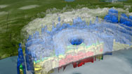
The fictional Hurricane Pam was created by Ivor Van Heerden in his supercomputer using data from past storms: wind, rain and storm surge.
IVOR VAN HEERDEN: What became very clear to us was that even a slow-moving Category 3 storm would totally flood New Orleans.
NARRATOR: This computer simulation was the focus of a 2004 disaster exercise held in Louisiana's capital of Baton Rouge.
MADHU BERIWAL (Emergency Management Expert): This was attended by about 300 people from the federal level, from the state level, and they sat together for about eight days and discussed some of the major issues that they would face if there was a catastrophic hurricane that struck New Orleans.
NARRATOR: The simulation showed New Orleans would be devastated: 61,000 people dead, over 175,000 injured and half a million homeless.
On the surface, participants seemed to take the exercise seriously.
WALTER MAESTRI: I think everyone involved, particularly on the local level, understood what we were dealing with, understood what the various roles were, who was going to do what, where, when and how.
NARRATOR: But underneath there was skepticism.
IVOR VAN HEERDEN: At the Hurricane Pam exercise we had a number of officials who, basically, scoffed at us.
NARRATOR: Would the lessons from the Pam simulation be heeded when the real threat came along? It's over a year after the Hurricane Pam exercise, and the 2005 hurricane season has begun. Thunderstorms are brewing off the west coast of Africa. One of these will give birth to Katrina.
STACY STEWART (National Hurricane Center): What the thunderstorms do is they draw heat from the ocean's surface. That's the driving mechanism that produces hurricanes.
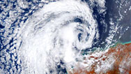
NARRATOR: Katrina begins as a small storm called a tropical depression, a center of low atmospheric pressure. In the warm waters of the eastern Atlantic, water vapor rises from the ocean then cools, forming clouds and releasing heat energy which fuels the storm. This sucks in more warm air, generating strong winds, which shoot upwards. When this rush of air hits the stratosphere, it flattens out, and, influenced by the Earth's rotation, the storm starts turning counterclockwise. As soon as the winds reach 39 miles per hour, the depression is considered a tropical storm.
This is Katrina minus six days, large, but still only a tropical depression. A day later, there's bad news: the Hurricane Center has upgraded the depression to a tropical storm. Roughly half of all tropical storms become hurricanes, so the team generates computer models to forecast where Katrina might strike.
In 2004, more than a third of the population of New Orleans evacuated for Hurricane Ivan, unnecessarily, as it turned out. But no warning at all can cost lives. Hurricane forecasts are improving due to a greater understanding of atmospheric dynamics and more extensive satellite coverage.
STACY STEWART: We rely very heavily on remote sensing via satellites, and we have various satellites in which we do that.
NARRATOR: But the team needs more data than even satellites can provide, so as soon as tropical storm Katrina is within range, they send out the Air Force hurricane hunters. Their mission: to fly right into the approaching storm.
As the pilot battles extreme turbulence, external sensors record wind speed, pressure and temperature to build up a more detailed picture of Katrina. And a new piece of technology has been added to the hurricane hunters' arsenal.
LIEUTENANT TINA YOUNG (U.S. Air Force Reserve): This is the dropsonde. It acts much like a weather balloon, collecting temperature, relative humidity and also pressure. There's also a GPS module that will be affected as it shifts from one point to the next. That will give us our wind direction and wind speed.
NARRATOR: The sonde is released through a chute in the floor.
TINA YOUNG: And then, as it floats down to the surface, it's radioing back all that data.
NARRATOR: As the sonde is tossed about, its GPS unit feeds back its position, relaying wind speeds at many different points in the storm.
Clearly Katrina is building. During this one flight, wind speeds have increased to 59 miles per hour, approaching hurricane force.
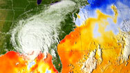
This data is fed to the Hurricane Center's supercomputers, which generate a prediction cone, where a black line shows the five-day forecast of the hurricane's likely track.
The hurricane is steered by zones of high and low atmospheric pressure surrounding it. These constantly shifting weather systems make track forecasting incredibly complex, but in recent years, the team has made huge advances.
MAX MAYFIELD: We've got a real success story here, and the observations are indeed better. The computers are faster and the computer modeling is much improved.
STACY STEWART: So now our five-day forecasts are exactly what our three-day forecasts were just 15 years ago.
NARRATOR: But intensity is much harder to predict than track, because the inner storm can change minute by minute. Katrina is still only a tropical storm; the key question is, "Will she become a hurricane?"
STACY STEWART: Well, here in the United States we categorize hurricanes as Category 1 through 5, with 5 being the worst.
NARRATOR: At the bottom of the scale is a Category 1, with wind speeds of up to 95 miles per hour, causing damage to trees and branches; Category 2: the hurricane has winds of up to 110 miles per hour, enough to punch the air out of your lungs; when the wind speeds hit 130 miles per hour, the hurricane becomes a Category 3; at Category 4, roof tiles are peeled off and houses will sustain structural damage. Category 5 is the most feared: with winds of more than 155 miles per hour, whole roofs are sheared off and houses destroyed.
But hurricanes deliver a deadly double blow, not just high winds but a massive bulge of water called the storm surge. The high winds push down on the ocean's surface, causing the water to rise like an unnaturally high tide. This wall of water is so dangerous that 90 percent of deaths in hurricanes come from drowning.
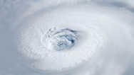
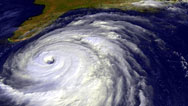
On Thursday, the 25th of August, Katrina finally grows into a Category 1 hurricane. She has formed an eye and is heading straight for southern Florida. Just three hours later, she hits land.
With no warm water to fuel her fury, Katrina dies down. But there's more warm water ahead in the Gulf of Mexico. In New Orleans, Walter Maestri watches the storm track nervously. He knows from near misses, like Hurricane Georges in '98 and Ivan last year, how vulnerable the city is.
New Orleans lies between two potential floodwaters: the Mississippi to the south and Lake Pontchartrain, connected to the Gulf, in the north.
WALTER MAESTRI: The metropolitan New Orleans area is a bowl. It looks like a gigantic soup bowl. We exist, on average, some seven to 10 feet below sea level.
NARRATOR: When the Mississippi flooded every year, it deposited silt to create vast boggy marshlands. The city itself was built on the only natural high ground, which would become the French Quarter.
Joe Suhayda is a coastal engineer who studies the city's defenses.
JOE SUHAYDA: The city was established at around the year 1700. And it was established on high ground that was adjacent to the Mississippi River. And this high ground was not flooded annually.
NARRATOR: Surrounded by marshlands, New Orleans couldn't grow until an engineer named Baldwin Wood designed a complex system of pumps and drainage canals to dry the city. Much of the system is still working today.
And with the flood-prone areas dry, New Orleans expanded outwards from the French Quarter, all over the drained wetlands. But this created a bigger problem.
IVOR VAN HEERDEN: In order to settle the areas, you've got to drain the water out of them well. As the soils then become drained, the organic matter breaks down just like compost, and so you lose bulk and the soils then shrink.
NARRATOR: The shrinking soils caused the city to sink further. To protect the growing population, the state built earthen levees, sometimes with prisoner labor.
But in 1927, the Mississippi burst her manmade banks, in a catastrophic flood that killed an estimated 500 people and destroyed more than a million homes. Many were in the poorest 9th Ward of New Orleans, where authorities dynamited the levees to prevent flooding elsewhere in the city. It is an event still recalled with bitterness.
And it was a turning point as the Army Corps of Engineers took control of the levees.
RICHARD WAGENAAR: From that point on, the Corps of Engineers and the federal government have had a large part to play in the levees, especially the Mississippi River levees in the city of New Orleans and southern Louisiana.
NARRATOR: Colonel Richard Wagenaar is now in charge of a 1,200-strong team. It's their responsibility to build and repair the levees to protect against hurricanes like Katrina.
New Orleans has two types of levee: the original earthen levees and more recently built concrete and steel floodwalls.
It was after Hurricane Betsy in 1965, that Congress set standards for the levees. Betsy was a Category 3 hurricane, causing extensive damage and flooding. Since then, Congress has provided the Army Corps of Engineers with funds to upgrade the levees to withstand a Category 3 hurricane and no more.
RICHARD WAGENAAR: A lot of the construction, our current day construction, was in the '60s. The floodwalls were all finished...early '90s. The system we were working on was a system to withstand a fast moving Category 3.
NARRATOR: But with Katrina growing in the Gulf, would Category 3 levee protection be enough? On Friday, the 26th of August, Walter Maestri receives a worrying phone call.
WALTER MAESTRI: The week that Katrina made landfall, I got a phone call from, from Max Mayfield, the Director of the National Hurricane Center.
MAX MAYFIELD: I called Walter Maestri, who is the Director of Emergency Managment of Jefferson in Louisiana, and I told him, "Walter, you better get ready."
WALTER MAESTRI: You've got to know Max Mayfield; he's an extremely low-key individual, not much upsets him. When you get that phone call from Max, it's serious.
NARRATOR: For Walter Maestri it's the news he's been dreading. The National Hurricane Center shows the storm heading straight toward the Gulf Coast, west of New Orleans, the very worst case scenario.
Since a hurricane spins counterclockwise, it generates stronger winds and more pressure on its eastern flank. So the storm surge to the east is also more severe, directly threatening New Orleans. With so many of its neighborhoods below sea level, New Orleans is going to need its strongest defenses.
Those defenses used to be provided by Louisiana's wetlands. Before its levees were built, the Mississippi River conveyed tons of silt and soil to the coast each year. Every spring, when the river flooded, the wetlands were strengthened and replenished. These wetlands protected New Orleans against hurricane storm surges, soaking up the violent waters like a sponge, while stands of cypress trees acted as a windbreak. But when levees were built, they kept the river from flooding. The wetlands became starved of new soil and started disappearing at an alarming rate.
Shea Penland is a coastal oceanographer who has witnessed this decline for over 30 years.
SHEA PENLAND (University of New Orleans): It's creeping up on us. It's occurring every day. The lands washing away every day, it's chronic.
NARRATOR: The depleted wetlands are more vulnerable to the encroachment of saltwater from the Gulf, which kills most freshwater plants. Louisiana's wetlands are vanishing at the staggering rate of at least 20 square miles a year, nearly a football field every hour. And as wetlands disappear, storm surges rise, putting New Orleans at even graver risk.
SHEA PENLAND: We dodged a bullet with Hurricane Andrew in 1992; we dodged a bullet with Hurricane Georges in 1998; and we dodged the atomic bomb with Ivan in '04.
NARRATOR: But would New Orleans dodge the bullet this time?
At Louisiana State University, Ivor Van Heerden and his team take what they know about Katrina and put it into the same computer model they developed for the disaster exercise called Hurricane Pam the year before.
Hassan Mashriqui is the man inputting the data.
HASSAN MASHRIQUI (Louisiana State University): From the beginning we saw that Hurricane Katrina was a very, very deadly storm. It would start to flood the lower parishes, and, as it became stronger and stronger, it just started to indicate that it's going to flood the city.
NARRATOR:Van Heerden takes the news public, sending email after email to officials in charge.
IVOR VAN HEERDEN: We knew on Saturday night that this was the big one, that it was going to sink New Orleans, and so we tried to get it...the word out as much as possible.
NARRATOR: Walter Maestri is desperately trying to get people to leave his parish.
WALTER MAESTRI: It was fairly obvious that this was going to be a storm that was going to land in our backyard—and we need about between 60 and 72 hours to get those who are willing to evacuate, evacuated—and that, therefore, we were going to have to move.
NARRATOR: But surveys conducted earlier indicated that not everyone would be willing or able to evacuate.
IVOR VAN HEERDEN: We understood that about 68.2 percent of the people would leave, which would have meant about 300,000 would have stayed.
NARRATOR: Many people have no transportation, but Lisa Monti, who does, decides to stay. She lives in Bay St. Louis on the Gulf Coast, 60 miles from New Orleans. She rode out one of the worst storms to hit the coastline, Hurricane Camille, in 1969.
LISA MONTI ( Bay St. Louis Resident): Camille didn't get us. We stayed here. It was a very long night, the walls shook, the floor shook, we had to scream, the wind was so loud, but the water from the beach didn't, didn't get near us in Camille.
NARRATOR: In her house, set back from the beach 20 feet above sea level, Lisa Monti assumes she is safe from Katrina.
And in the heart of New Orleans, Africa Brumfield, with her house 12 feet below sea level, decides to remain as well.
AFRICA BRUMFIELD: Some of our family members decided that they would leave, but my parents decided to stay, and I wasn't going to leave them and go to safety. So I decided to stay with them.
NARRATOR: But Max Mayfield and his hurricane watch team keep making frantic calls to warn of the impending danger.
MAX MAYFIELD: I wanted to be able to leave the Hurricane Center that night knowing that I'd done everything that I could do.
NEWS REPORTER: Jeff, we're going to start with you again. Of course, New Orleans, under a hurricane warning. And now it has been bumped up to Category 5.
NARRATOR: The Army Corps of Engineers is evacuating most of its staff to be on standby, safe from the storm.
RICHARD WAGENAAR: We have a plan for a team to remain behind in New Orleans, an eight or nine-man team in a bunker that's certified for a Category 5 storm.
Perry Lartigue is one of the men who stays to monitor the levees.
PERRY LARTIGUE (U.S. Army Corps of Engineers): ...and this is the bunker. This is the room that we manned the phones from, the EOC office. There was eight of us with Colonel Wagenaar.
NARRATOR: Walter Maestri decides to evacuate most of his personnel.
WALTER MAESTRI: We get to a minimum staff very quickly, implement what we call our Doomsday procedures, and make sure that the fewest possible folks are at risk.
NARRATOR: The mayor issues the city's first ever mandatory evacuation.
RAY NAGIN (Mayor of New Orleans/News Footage): Every person is hereby ordered to immediately evacuate.
NARRATOR: But for Ivor Van Heerden, armed with his prophetic knowledge, desperation is setting in.
IVOR VAN HEERDEN: I knew we were going to lose a lot of people. I knew there was going to be super devastation. I knew there would be thousands of families who would lose their livelihoods, lose their homes. I knew that we were going to see an awful amount of heartbreak.
NARRATOR: The city streets are all but deserted. Those who have remained are inside, preparing for the night ahead. The small contingent from the Army Corps makes hourly visits to check the height of the Mississippi.
PERRY LARTIGUE: We're reading gauges about from 3:00 or 4:00 in the Sunday evening. The last gauge I went out and read was at 10:30.
NARRATOR: Though the hurricane has not yet made landfall, the river has risen 11 feet.
AFRICA BRUMFIELD: Around 10:30 or 11:00, the wind started to get more and more rough.
NARRATOR: The Army team is forced to retreat to their steel reinforced bunker and watch as Katrina wreaks her fury.
PERRY LARTIGUE: We kept looking out the front door porthole watching the wind blow, but we felt safe.
NARRATOR: Outside, storm chasers are experiencing the storm's dramatic build up firsthand.
AFRICA BRUMFIELD: Around midnight it got really bad. It was blowing to the point where the house would shake—not a lot, but it would move—and you knew something was different about the way the wind was blowing.
RICHARD WAGENAAR: It was very cramped, and of course the adrenalin is very high. We've never been in a bunker for a hurricane.
PERRY LARTIGUE: The wind wasn't rattling and just moving and shaking; it was banging like a bulldozer beating against the wall. It was just hitting, boom, boom.
AFRICA BRUMFIELD: And the house was shaking. It sounded like the walls were trying to just fall apart. And it was a scary feeling, and I started to feel like I was in a coffin.
NARRATOR: At 6:10 a.m., Katrina strikes land. The National Hurricane Center has amazingly predicted her track to within about 15 miles. She has now veered to the east of the city, avoiding the worst case scenario, but there is no escaping Katrina's devastating power.
Watching events from Baton Rouge, Ivor Van Heerden and his team are especially concerned about the levees on the eastern side of the city.
IVOR VAN HEERDEN: We felt that the levees could be overtopped. During Hurricane Betsy we had lost significant amounts of levees, especially on the Industrial Canal, and our fear was the same thing was going to happen again.
NARRATOR: The eastern sections of New Orleans are bordered by the Industrial Canal and the Intercoastal Waterway, which connects to the Gulf. Katrina's storm surge would fire like a bullet up the Intercoastal Waterway toward the heart of the city. But if it happens, no officials will know. The Army Corps of Engineers has no external monitoring equipment.
While the power lasts, the engineers rely on the media.
RICHARD WAGENAAR: We got a lot of reports, people calling in and reporting things wrong with levees.
NARRATOR: Despite the confused nature of the calls, it is becoming clear that something has gone wrong with the levees.
At about 7 a.m., a massive storm surge charges into eastern New Orleans. A 15-foot wave is funneled up the Intercoastal Waterway and smashes into the Industrial Canal like a runaway train. The earthen levees around the canal are first overtopped and then scoured away by the force of the water.
Hit immediately are New Orleans East, the Lower 9th Ward and the Upper 9th. Residents of these poor, and working class areas had been warning for years about the threat of a storm surge.
The water rushes into the Lower 9th Ward and St. Bernard Parish at incredible speed. Seventy-seven-year-old August Hubbard had taken shelter in a small hotel in the Lower 9th, but a 10-foot surge of water floods the building within minutes. A Navy veteran of Korea and Vietnam, he finds himself swimming for his life.
AUGUST HUBBARD (Lower 9th Ward resident): And the water was up to my chest, but I took a stumble and went down, and the water was up to my mouth almost. They might have snakes, they might have alligators, they might have anything in the water. We could see, like, somebody's gas pipes, and I could see, like, streams of bubbles coming up, and that was gas.
NARRATOR: Once again, as in the Great Flood of 1927, the Lower 9th Ward is devastated. People are left to fend for themselves as the water rises. And the storm is not over yet.
At around 10 a.m., Katrina makes landfall again, near Bay St Louis and Gulfport, 35 miles northeast of New Orleans. Here, on the dangerous eastern side of the eye, the storm surge is a phenomenal 28 feet. Recorded by storm chasers, houses and cars are swept away by the incoming water.
In Bay St Louis, Lisa Monti, supposedly safe on high ground, is stranded on her upstairs balcony.
LISA MONTI: The water had raced down the road and filled the yard. And all the debris, as it came in, the building shook and rocked so much that I didn't know how long it would stand.
NARRATOR: All along the coast, entire communities are wiped out.
Back in New Orleans, confusion reigns. Electricity is off, land lines and cell phone networks are down. With communications decimated, city officials and emergency teams are unaware of the extent of the damage, especially the flooding in the 9th Ward.
By early afternoon, Katrina is moving inland, progressing north and gradually weakening.
WALTER MAESTRI: When the storm left and started to move to the north, we felt blessed, because it appeared that Katrina had not been, you know, as devastating as we thought.
NARRATOR: But they couldn't be more wrong. A second huge flood has already hit the city.
Around 2 p.m., Colonel Wagenaar and his engineers finally head downtown to check on vague reports of damage to the drainage canals at London Avenue and 17th Street.
RICHARD WAGENAAR: There was a civilian that had told us that there was an overtopping or something wrong with the wall.
NARRATOR: But over a mile from the 17th Street Canal, they are stopped in their tracks.
RICHARD WAGENAAR: We could not get any closer. We encountered significant amounts of water at what we call the I-10/610 split on the interstate highway, probably about 10 to 15 feet of water. I knew, at that point, that that was much more water than had come down from rainfall.
NARRATOR: The 17th Street and London Avenue Canals burst in three major locations, sometime around 10 a.m. Throughout the day, water from Lake Pontchartrain pours, at high pressure, into the heart of New Orleans. The city's huge pumps, only designed to deal with rainfall, are no match for the rising water. Nothing can be done to stop the water gushing in through the gaping breaches in the two canals.
JOE SUHAYDA: One of the problems is that the system is designed to keep the water out, but there was no provision really for managing the water once it got inside the city.
RICHARD WAGENAAR: There wasn't a specific plan to fight the floods if a floodwall failed. We had a plan from the organizational perspective, but not specifically to fight if there was a failure of a floodwall.
NARRATOR: As the afternoon progresses, water continues to pour into the city. The New Orleans bowl is filling up.
Africa Brumfield's home is downtown, near the London Avenue Canal, right in the path of the second flood.
AFRICA BRUMFIELD: I sat outside from about 3:00, when the water started to come in, until maybe 7:00 that night, watching the water rise from the ground. And it continued to rise, and it continued to rise. So we went into the house, and we figured it will stop. So I tried to lie down and go to sleep, but who can rest in a situation like that?
RICHARD WAGENAAR: It was getting dark. And that night we returned to the district and just hunkered down for the night—there was only still the nine of us—and waited for the next morning to get back out there and do our assessments.
NARRATOR: By nightfall, the water is still rising, but with communications out, many in the sleeping city are unaware of the danger.
IVOR VAN HEERDEN: We could have got vehicles driving on the interstates with bullhorns telling people. We even could have used helicopters with bullhorns. We could have warned the people "A big flood's coming, take evasive action." We didn't.
People went to bed on Monday evening, houses dry, and woke up in the middle of the night with water up to their waists.
AFRICA BRUMFIELD: I got up around midnight, and it was still rising in the house. And my house sat up about four feet off of the ground. And I was thinking, "If my house is four feet off the ground, and the water is in my house, I'm only five feet one, and it's in my house about two feet, there's no way that I'm getting outside without going for a nice swim."
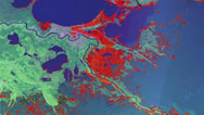
NARRATOR: As dawn breaks on Tuesday, the extent of the damage is becoming clear. There are multiple breaks in the levees: two major ones on the Industrial Canal that flooded the 9th Ward to the east, and three on the 17th Street and London Avenue Canals, which filled up the central city bowl. Seventy-five percent of Greater New Orleans is now under water, and it is still full of people. Rescue teams are massively overloaded.
For more than a half-century, no U.S. hurricane has affected so many.
BILLY GOMILLION: We worked from probably 5:00, all through the night, without stopping, into the next night.
AFRICA BRUMFIELD: We grabbed air mattresses and pots, because we needed something to paddle with. And we got in the water, and we started to paddle on the air mattresses with the pots. People are screaming, "Help us, can you please help us?"
I sent two of my really good friends back, and they saved a lot of elderly people that really couldn't walk or move, and a lot of little children.
BILLY GOMILLION: I was bringing out at least 50 people per run, and I made runs for a week solid. I was worn out. You always hear about the Doomsday storm that they've been predicting for 100 years to hit this city. Well this was it.
NARRATOR: When the water finally stops rising in the flooded city, work can resume on fixing the floodwalls. With roads and canals blocked, the Army Corps of Engineers is initially restricted to helicopters.
COLONEL DUANE GAPINSKI (U.S. Army Corps of Engineers): ...the Chinook helicopter, a medium lift helicopter. And there are three, should be three sandbags underneath that, and it is reinforcing one of the sites that was breached on the London Avenue canal. So underneath all of this rock and gravel are sandbags—well, you can see them right here—sandbags just like that. So they're flying over to that breach, dropping the sandbags and building up the height of that wall that's stopping the water from moving from the canal to the flooded areas.
NARRATOR: Eventually the breaches are filled and the water begins to be pumped out, but it will take over a month before the city is dry.
In the meantime, rescue efforts continue. Hundreds are pulled from their wrecked homes. Seventy-seven-year-old August Hubbard from the Lower 9th Ward spends a freezing night after swimming to an overpass until a helicopter finally picks him up.
AUGUST HUBBARD: Helicopters kept passing and waving at us. They put me in the hospital. I stayed in the hospital for three and a half days, 'cause I had the diarrhea, and they were checking my heart and stuff like that. Then they brought me to an airplane hangar, and there were, like, about 4 or 5,000 people in there, and we were sleeping on mattresses.
NARRATOR: The chaotic official response means that there is still no food or water available to the crowds of people in the city. For many, there is no way out; civilization is breaking down around them.
AFRICA BRUMFIELD: We passed a lady in a hospital bed being pushed on the Interstate, and all of a sudden reality hits you of where you are and what's really happening to you.
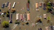
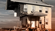
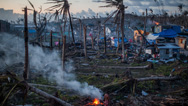
NARRATOR: The rescued and displaced are told to head for shelter at the Superdome and the Convention Center. In a story that's all too familiar: many are forced to wait in squalid conditions for days. All around them the city lies in ruins. Sixty thousand houses in New Orleans and other communities are eventually declared damaged beyond repair. In New Orleans alone, over 1,000 people have lost their lives.
BILL GOMILLION: It's just something I never in my wildest dreams thought I would ever see or could ever happen. Who would have ever thought 100,000 people, you know, would stay for a Category 5 hurricane. I guess the reason they stayed is who would ever think the levees would fail?
NARRATOR: So was the damage and loss of life avoidable? Why did the levees fail?
In the wake of the storm, questions began to be asked. And they focused on the height of the storm surge.
On the Gulf Coast, Bay St. Louis was on the dangerous eastern side of the eye when the surge hit. Lisa Monti's town experienced the maximum 28-foot height of the surge.
LISA MONTI: You could see how massive the wall of water was that climbed up and did all of this destruction. As far as you can see, on either side of the beach, there is nothing. I have heard so many of the workers who were from out of town say, "I can tell that this was a special place."
NARRATOR: New Orleans was on the less powerful western side of the hurricane. Still, a wave of 18 to 25 feet shot up the Intercoastal Waterway and along the Industrial Canal. It overtopped the Category 3 levee walls by more than five feet, scouring away their foundations and pushing them aside. It became clear that overtopping was the main reason the levees had failed around the Lower 9th Ward.
But the breaches that flooded downtown New Orleans were more difficult to figure out. By the time the storm surge reached the 17th street and London Avenue canals, its height was much lower. In theory, the floodwalls along these two canals should not have failed like the overtopped levees of the Industrial Canal to the east. The water never got within two feet of the top.
IVOR VAN HEERDEN: The London Avenue or 17th Street canals did not experience Category 3 conditions. They experienced conditions of a Category 1 or Category 2 storm, so the design criteria weren't exceeded.
NARRATOR: So if they weren't overtopped, why did they fail?
That is the subject of a major engineering investigation.
JOE SUHAYDA: We're right now at the northern end of what is called the 17th Street Canal, right at the lake shore. That's the breach. That's ground zero as it was called. As with a boat, you need only one hole and a whole boat can sink—this was actually the weak link in the chain.
NARRATOR: But the problem lies deeper than the concrete floodwall itself. Joe Suhayda is looking for evidence to support his theory that the walls here were not overtopped but undermined.
JOE SUHAYDA: Now was this dirt always here, this hill?
See, that's what we suspected. This area was, as we suspected, about 30 feet closer to the water. And the movement of the earth, which went sideways, actually lifted the house up, you say? That's amazing.
NARRATOR: The floodwalls had undergone what engineers call a pressure burst. They were undermined by their own foundations: soft peaty soil, no match for the force of the water.
JOE SUHAYDA: This is what we had suspected in terms of the mechanism of failure, was that the floodwall failed at the base. The earth was too weak, and the sheet piling itself and the monolith, the concrete structure, were just pushed laterally like the blade of a bulldozer.
NARRATOR: Evidence suggests that the floodwall failures could have been prevented if the pilings had been driven more deeply into the ground.
IVOR VAN HEERDEN: What is now very obvious is that these walls were under-designed, under-engineered. It was basically a catastrophic structural failure of those levee systems.
NARRATOR: The Army Corps of Engineers plans to repair the levees up to Category 3 by next hurricane season. But the floodwall failure has called into question the reliability of the entire levee system, just at a time when it may be needed more than ever.
2005 turned out to be the busiest hurricane season on record. Katrina was swiftly followed by Rita—causing more damage to the Gulf coast—Stan and Wilma—devastating Mexico and Florida. Meteorologists have now run out of letters in the Roman alphabet. Moving on to the Greek, the first ever Hurricanes Alpha and Beta have been recorded. For decades, scientists have understood that hurricanes come in cycles.
MAX MAYFIELD: We think, here at the National Hurricane Center, that hurricane activity is cyclical, and you'll have some active periods followed by inactive periods followed by active years again. And, in fact, the, the '40s, '50s and '60s were very active in the Atlantic Basin; the '70s, '80s and early '90s very inactive; and then 1995, we really became active again.
NARRATOR: But some scientists believe that cycles alone do not explain the increase in powerful hurricanes. Studies of global hurricane activity over the last 30 years have shown that although hurricane frequency seems unchanged, the average intensity has increased. The number of Category 4 or 5 storms has almost doubled.
Peter Webster believes this is linked to rising ocean temperatures all over the world.
PETER WEBSTER (Georgia Institute of Technology): The bottom line of our study is that we found a consistency between the increase of surface temperature in all of the oceans and a change in intensity to more intense storms.
NARRATOR: Over the last 30 years, global sea surface temperatures have climbed about one degree Fahrenheit, or over half a degree centigrade, and this provides a vast amount of extra energy for hurricanes.
SIMON BOXALL (National Oceanography Centre, Southampton, United Kingdom): One hurricane is equivalent to 100,000 atomic bombs. That's incredible power. In just one area, such as the Gulf of Mexico, that small half-degree increase in temperature of the sea's surface is the equivalent energy of about a million atomic bombs.
If we're thinking of it in terms of the fact that there's enough energy in that half degree to generate an extra 10 strong hurricanes, then you start to see the size of the problem.
NARRATOR: Global warming, the heating of the atmosphere often associated with human activity, has been invoked to explain both the rise in ocean temperatures and more intense hurricanes.
But not everyone agrees.
MAX MAYFIELD: A lot of people ask about the relationship between hurricanes and global warming, and that's certainly a fair question. We think that hurricane activity can be explained without invoking global warming.
NARRATOR: But scientists do agree that things are going to get worse before they get better.
MAX MAYFIELD: The, the bad news here is that the research meteorologists tell us that this active period that we're in could very well last another 10 or 20 years. So my message there is, no matter what, that we're in this active period, and we need to all be prepared.
NARRATOR: With its defenses found wanting, New Orleans will have to struggle to be ready for the next assault. All indications are that the levees and floodwalls are not up to the job of protecting the city even from a Category 3 hurricane. There is no money to upgrade them, even though more Category 4 and 5s are expected.
JOE SUHAYDA: Category 3 protection was not adequate. It's clear to me that if we are going to rebuild the city, that it has to be built on a basis of Category 5 protection. It clearly would have made sense to protect and avoid the federal government spending hundreds of billions of dollars by investing an additional, let's say, two billion dollars in levee protection.
NARRATOR: But levees are not the only way to protect a sinking city. More radical options are now on the table.
JOE SUHAYDA: Much of the city is below sea level. I think, given the opportunity in situations like what's over my shoulder here, where the area would have to be completely demolished, that we rebuild those and basically invert the bowl—bring sediments in to raise the ground, perhaps up as high as we're standing right now.
NARRATOR: But preventing further destruction of the environment may be as effective as any ambitious rebuilding scheme.
IVOR VAN HEERDEN: The ultimate key to Louisiana's survival and reducing the impacts of surges is to restore our coastal wetlands. These wetlands knock down the surge and they also reduce wind energy as the storms pass over them.
NARRATOR: After nearly a century of building levees to control the Mississippi, one idea is to let parts of the river run wild once more. This plan would create a new tributary that would be allowed to flood, deposit silt and rebuild the wetlands. This would cost billions and take as long as 50 years.
But just as difficult may be the task of rebuilding the confidence of the people of New Orleans. Both the disaster and the long, slow process of rebuilding have convinced many not to return.
AFRICA BRUMFIELD: This was home, and I've been all over the world thanks to the military. Nothing ever felt like New Orleans, ever. But I can't come back to live. Going through that again is too scary.
NARRATOR: For those who had long predicted this calamity, all the attention now being given to hurricane protection has brought no contentment. With around 1,300 dead and 800,000 homeless, the price has been far too high.
WALTER MAESTRI: It's hard to say it, but I knew I was right. I knew that it could happen. It's horrible that it did. And what I see around me now, on the faces of the individuals who have lost everything and don't know what's going to happen to them, that's devastating. That's the devastating part.
NARRATOR: And for those scientists who'd seen their warnings ignored, it hits especially hard.
IVOR VAN HEERDEN: You know I'm really heart-sore for those people. You walk past some of these homes, only half of them are standing, because they've been destroyed by the floods. They've lost so much, so, so much. And I think that's the, the really hard part for me to take, as I knew it was coming. And to go and see it day after day is really distressful.
NARRATOR: On NOVA's Web site, see how the storm that drowned a city overwhelmed New Orleans's defenses in just a few hours. Find it on PBS.org.
Broadcast Credits
Storm That Drowned a City
PBS Airdate: November 22, 2005
- Written, Produced and Directed by
- Caroline Penry-Davey
Peter Chinn - Executive Producer For Pioneer Productions
- Mike Beckham
- Location Directors
- Becky Lee
Tom Stubberfield - Associate Producer
- Jasmine Dick
- Narrated by
- Neil Ross
- Edited by
- Huw Jenkins
Francis Robertson
Elliot McCaffrey - Camera
- Robert Bock
Paul Bulley
Jason Ellson
Geoff Mackley
Mark Regan - Sound Recordists
- Rory Ambron
Simon Bishop
Adam J Butterworth
Thierry Frankel
Jonathan Michell - Music
- Guy Dagul
Audio Network Plc - Graphics
- Clarke Associates
- Business Affairs
- Julia Behar
- Head of Production
- Kirstie McLure
- Production Manager
- Marie-Louise Frellesen
- Online Editor
- Chris Edwards
- Audio Mix
- Nick Rogers
John Jenkins - Archive Research
- Lucy Haken
- Archival Material
- Barataria Terrabone Estuary Program
Film Preservation, Colorlab Corp.
Herbert Hoover Presidential Library
ITN Archive
LSU Aerial Video Survey Program
Maritime and Seafood Industry Museum, Biloxi
NARA
NASA
NOAA
Prairie Pictures/Stormstock
The Louisiana Multimedia Archives
Ultimate Chase
WAFB, Baton Rouge - Special Thanks
- Additional funding for this program provided by BP
Tika Lauden, Louisiana Public Television
Jason Dunion, NOAA
Ray Seed, UC Berkeley
Peter Nicholson, University of Hawaii - NOVA Series Graphics
- yU + co.
- NOVA Theme Music
- Walter Werzowa
John Luker
Musikvergnuegen, Inc. - Additional NOVA Theme Music
- Ray Loring
- Post Production Online Editor
- Spencer Gentry
- Closed Captioning
- The Caption Center
- NOVA Administrator
- Dara Bourne
- Publicity
- Eileen Campion
Olivia Wong - Senior Researcher
- Barbara Moran
- Production Coordinator
- Linda Callahan
- Unit Manager
- Lola Norman-Salako
- Paralegal
- Richard Parr
- Legal Counsel
- Susan Rosen Shishko
- Post Production Assistant
- Alex Kreuter
- Associate Producer, Post Production
- Patrick Carey
- Post Production Supervisor
- Regina O'Toole
- Post Production Editor
- Rebecca Nieto
- Post Production Manager
- Nathan Gunner
- Supervising Producer
- Stephen Sweigart
- Producer, Special Projects
- Susanne Simpson
- Coordinating Producer
- Laurie Cahalane
- Senior Science Editor
- Evan Hadingham
- Senior Series Producer
- Melanie Wallace
- Managing Director
- Alan Ritsko
- Senior Executive Producer
- Paula S. Apsell
A Pioneer production for NOVA in association with WGBH/Boston, FIVE, Spiegel TV and Arte.
© 2005 WGBH Educational Foundation
All rights reserved
Image
- Photo: (flooded neighborhood)
- Courtesy FEMA
Sources
Links
News Updates from The Times-Picayune
www.nola.com
The New Orleans Times-Picayune Web site offers extensive coverage of Hurricane Katrina's aftermath. View Web cams and photographs of the city, participate in message boards, and get an insider's view of New Orleans as it recovers from the storm.
Center for the Study of Public Health Impacts of Hurricanes
www.publichealth.hurricane.lsu.edu/
This Louisiana State University site provides a wealth of information on the public health impact of hurricanes and major floods, from satellite maps of potential hazard areas to detailed reports on current research.
Hurricane Resource Page
www.nasa.gov/vision/earth/lookingatearth/hurricane_2005.html
On this NASA Web site, learn about the science of hurricanes, track storms as they move across the Atlantic Ocean, view satellite images of the Gulf Coast during Hurricane Katrina, and more.
Katrina
www.npr.org/templates/topics/topic.php?topicId=1092
Hear NPR's full coverage of Hurricane Katrina and its repercussions, from early reports filed during the storm's landfall to the latest coverage of New Orleans' attempts to rebuild.
Hurricane Katrina Aftermath Information
www.mvn.usace.army.mil/katrina/
Learn what the U.S. Army Corps of Engineers is doing to prepare New Orleans for future storms, download reports on the failure and gradual reconstruction of the city's levee and flood wall systems, view photos of the Corps at work, and more.
New Orleans Flood Map
mapper.cctechnol.com/floodmap.php
On this interactive map, find the depth of New Orleans floodwaters on a street-by-street basis. Users may search by entering a specific address or by clicking on a desired area.
Family Linking
www.katrinasafe.com/main.aspx
The American Red Cross hosts a massive online database on the whereabouts of hurricane evacuees, allowing users to search for missing friends or loved ones. The site will remain active until February 28, 2006.
FEMA
www.fema.gov
The Federal Emergency Management Agency's Web site offers information on governmental aid efforts and Web resources for hurricane victims and volunteers.
Recording Katrina
recordingkatrina.blogspot.com
Read firsthand accounts of Hurricane Katrina and its impact from those who lived and worked in its path.
Books
Hurricane Katrina: The Storm That Changed America
by Editors of Time Magazine. Time, 2005.
Divine Wind: The History and Science of Hurricanes
by Kerry Emanuel. Oxford University Press, 2005.
Land's End: A History of the New Orleans District, U.S. Army Corps of
Engineers, and Its Lifelong Battle With the Lower Mississippi and Other Rivers
Wending Their Way to the Sea
by Albert E. Cowdrey. U.S. Army Corps of Engineers New Orleans District, 1977.
An Unnatural Metropolis: Wresting New Orleans From Nature
by Craig E. Colten. Louisiana State University Press, 2004.
Hurricane Watch: Forecasting the Deadliest Storms on Earth
by Jack Williams and Bob Sheets. Vintage Books, 2001.
Extreme Weather: A Guide and Record Book
by Christopher C. Burt and Mark Stroud. W. W. Norton & Company, 2004.
Preview
Full Program | 52:31
Full program available for streaming through
Watch Online
Full program available
Soon

Related Links
-

Inside the Megastorm
Watch as Megastorm Sandy unfolds, and explore what made it so much more devastating than other hurricanes.
-
Hurricanes and Climate Change
Why climate change is making hurricanes more dangerous.
-
Anatomy of Katrina
Track the hurricane from its birth in the open ocean through its catastrophic encounter with the Gulf Coast.
-

The Man Who Predicted Katrina
Hurricane expert Ivor van Heerden warned for years that a tragedy like the one brought by Katrina was bound to happen.
-
Stronger Hurricanes
Is global warming making hurricanes more intense?
-

Storm Surges and New York City
How multiple lines of defense, from massive barriers to oyster reefs, can protect our cities from storm surges.
-
How New Orleans Flooded
Examine a chronology of exactly where and how 85 percent of the city wound up underwater following Hurricane Katrina.
-

Dealing with the Deluge
The Mississippi, Nile, and Yellow Rivers are prone to disastrous flooding. How have engineers tried to stop it?
-
Hurricane Power
Your average hurricane releases enough energy to power the world 200 times over. Go figure.
-
Quiz: Hurricanes
Five questions that will separate the hurricane know-it-alls from the rest of us
-

Hurricane Katrina: Expert Q&A
Research meteorologist Marshall Shepherd answers questions about hurricanes and the ongoing threat to New Orleans.
-

Profile: Tyler Curiel
In the midst of Hurricane Katrina, a cancer researcher risks everything to save a medical treasure.
-

Dispatch: Hurricane Katrina
Louisiana-based hurricane expert Ivor Van Heerden shares his agonized response to the disaster he'd long predicted.
-
Calling Katrina
Jonah Lehrer discusses new research into hurricanes that may help explain Katrina's devastating impact.
-

Hotter Oceans, Fiercer Storms
In this audio slide show, examine the link between rising sea surface temperature and more intense storms.
-

Tyler Curiel: Expert Q&A
Cancer researcher Tyler Curiel answers questions about surviving Katrina and salvaging his life's work.
-
Megastorm Aftermath
How can cities prepare for rising seas and raging storms?
-
Killer Typhoon
What made Haiyan so destructive, and how can we prepare for the next monster storm?
-

Better Forecasts with Drones
How tropical cyclones intensify remains a mystery, but unmanned aerial vehicles could fill critical gaps in the data.


National corporate funding for NOVA is provided by Draper. Major funding for NOVA is provided by the David H. Koch Fund for Science, the Corporation for Public Broadcasting, and PBS viewers.