
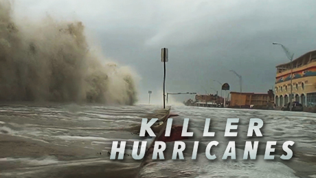
Killer Hurricanes
Experts reconstruct the Great Hurricane of 1780 to help predict the risk of future storms. Airing November 1, 2017 at 9 pm on PBS Aired November 1, 2017 on PBS
Program Description
Transcript
Killer Hurricanes
PBS Airdate: November 1, 2017
NARRATOR: Our planet is capable of unleashing extreme chaos. Volcanoes, earthquakes, hurricanes and floods can cause untold devastation. We may think we've seen the worst Mother Nature can throw at us, but scientists struggling to understand these disasters are discovering evidence that even more extreme events have struck in the past.
JEAN CHRISTOPHE KOMOROWSKI (Institut de Physique du Globe de Paris): So, this is about 13 times more powerful than the Pompeii eruption.
NARRATOR: They're uncovering clues that the worst catastrophes in history could strike again.
More than 200 years ago, a disaster tore through the Caribbean.
WAYNE NEELY (Nassau Department of Meteorology): This is by far the deadliest hurricane to ever impact the entire Caribbean.
NARRATOR: The Great Hurricane of 1780 was both huge and powerful. But can we trace its impact using today's tools, because it appears that storms are becoming more powerful.
MARSHALL SHEPHERD (University of Georgia): We believe that there should be more intense storms, perhaps not as many of them are happening, but when they do, they'll be stronger.
NARRATOR: The clues are here, buried and hidden beneath the waves and beneath the ground.
AMY FRAPPIER (Skidmore College): There's this whole history in here about what's happened over time.
NARRATOR: Now, scientists and historians come together, to scour our volatile earth, to find out if, in the future, there will be more Killer Hurricanes, right now, on NOVA.
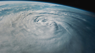
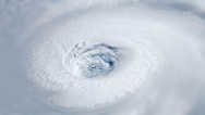
Hurricanes: some of the most powerful natural forces on Earth; called typhoons or cyclones in the Pacific, these storms build up over warm waters and can reach hundreds of miles across. Storms like Harvey, Irma, Maria, and Typhoon Haiyan are synonymous with death and destruction.
KERRY EMANUEL (Massachusetts Institute of Technology): Hurricanes kill, on average, 10,000 people a year.
MARSHALL SHEPHERD: They can cause death. They can actually destroy infrastructures, entire cities.
WOMAN (New Jersey resident in the aftermath of Sandy): It's just complete devastation, it's unbelievable.
NARRATOR: In 2017, a series of catastrophic hurricanes, Harvey, Irma, and Maria, impacted millions of people in the US and the Caribbean. Entire islands and the city of Houston were devastated. Is this the worst that nature can throw at us? To find out, scientists are hunting for clues in the distant past.
MARSHALL SHEPHERD: The more we understand about them, the better we can predict them.
NARRATOR: They're unearthing evidence of the deadliest hurricane in Atlantic history, the Great Hurricane of 1780.
WAYNE NEELY: It destroyed every house in Barbados, and it devastated this massive fort.
MIKE CHENOWETH: That storm was truly exceptional.
NARRATOR: And looking even further back in time, scientists are discovering that 1,000 years ago, major Atlantic hurricanes may have struck more often.
JEFF DONNELLY (Woods Hole Oceanographic Institution): And then you get this really big layer, here, that dates to about 1,000 years ago.
NARRATOR: So, were monster hurricanes more frequent or more powerful in the past? And what does this bode for the future?
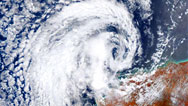
Two record-breaking hurricanes struck the Caribbean in September 2017. The first, Irma, leaves a trail of destruction across the islands of Barbuda, St. Martin, and St. John. Its 185 miles an hour winds blow for a record 37 hours. Then, less than two weeks later, comes Maria. Its sustained winds blast the entire island of Puerto Rico, destroying the power grid, water supply, roads, and cell towers. For weeks, millions are stranded in the dark, without clean water, food, gas, or phones. The terrible toll of these storms puts them in the record books. But there is growing evidence that hurricanes just as powerful could once have been more common.
Wayne Neely, a meteorologist and historian has come to the National Archives on the island of Barbados, the most easterly of all the Caribbean islands. He's here to investigate the deadliest Atlantic hurricane since records began, the Great Hurricane of 1780.
According to historical documents, this storm was so destructive it killed an estimated 22,000 people across the Caribbean.
And on October 10th, 1780, the first place it strikes is the island of Barbados, then under British rule. In the records from the time, Wayne finds evidence of the human cost.
WAYNE NEELY: Here in these dead records we have 4,500 names of persons who died in this Great Hurricane of 1780: Elizabeth Finlay, Thomas Fisher, Nehemiah Fish, William Folkes, Richard Forster, Elizabeth Forte, these are a few names of persons who died in that storm in Barbados.
NARRATOR: And, in the archives, Wayne also finds a harrowing eyewitness account that describes the fate that likely befell many of these people. It's a letter, written by the Commander in Chief of the British Forces in the Leeward Islands.
WAYNE NEELY: This is a letter written to the King by Major General Warren, "I do not believe that 10 houses are saved in the whole island. Whole families were buried in ruins of the inhabitations. Many, in attempting to escape, were maimed and disabled, the ground covered with mangled bodies of their friends and relations."
NARRATOR: Almost all buildings, whether stone or wood, were torn apart.
WAYNE NEELY: Well, it must have been a really great storm to destroy all the buildings on the island. So, you can imagine the horror and the misery that the residents of Barbados felt during the peak of the storm. It was horrifying and horrific.
MIKE CHENOWETH: You have no home to go to, you have no food. The fresh water supply is now destroyed.
NARRATOR: In 1780, the people of Barbados are far from the only victims. In the following days, the storm kills thousands more on islands to the north and west.
WAYNE NEELY: The whole region was devastated. Islands such as Martinique, St. Lucia, St. Vincent and Grenada all reported death tolls from the storms.
REG MURPHY (International Association for Caribbean Archaeology): The wind is going to destroy your plantations; it's going to destroy everything; you'll lose all your supplies.
NARRATOR: In 1780, it's estimated that 22,000 people are killed immediately. Most of the victims are slaves, brought over from Africa to work on the sugar plantations. Then thousands more die in the aftermath, from starvation and disease.
REG MURPHY: It's always the lowest end of the economic chain that feels the effects of these things first. The slaves are going to die off first. And most of them did.
KERRY EMANUEL: Certainly, the 1780 hurricane was the deadliest hurricane we know about in the western hemisphere.
NARRATOR: The records also reveal, just as in 2017, this storm was one of three devastating hurricanes that struck in quick succession.
KERRY EMANUEL: 1780 was a terrible year for hurricanes; there were three incredibly destructive ones.
NARRATOR: Only a week earlier, another hurricane had struck the region. And then, just over a week later, another struck, also with catastrophic effect.
But the death toll from the Great Hurricane overshadows them all. Even today, storms like Hurricane Katrina that struck the Gulf Coast in 2005, and Hurricane Mitch, the deadliest Atlantic hurricane in living memory, which hit central America in 1998, can leave thousands dead in their wake.
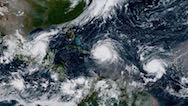
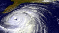
So, what makes these killer storms so unusual? And will they become more frequent? Modern hurricanes, like Harvey, Irma, and Maria, are tracked by aircraft and weather satellites. What we've learned about them gives scientists an idea of how the 1780 storm likely formed and developed.
On August 27th, 2017, 9 days before it makes landfall in the Caribbean, Irma begins as a storm off the west coast of Africa. As it travels west to cross the Atlantic Ocean, it quickly gathers strength.
Heat rising from the warm ocean waters feeds energy into the storm system.
MARSHALL SHEPHERD: Hurricanes are like heat engines, they actually convert the energy from the ocean into motion in the hurricane.
NARRATOR: Warm, moist air cools as it rises and then condenses.
MARSHALL SHEPHERD: That releases that energy that was carried away from the ocean, and that powers the storm.
KERRY EMANUEL: And one of the reasons hurricanes are so intense is the ocean is very warm and the air at the top of the hurricane is very cold.
NARRATOR: These winds can then spin into a powerful cyclone, partly a product of Earth's rotation, with the rain bands stretching hundreds of miles across. August 30th, as wind speeds reach 50 miles an hour, Irma becomes a named hurricane. Over the next six days, it intensifies rapidly. By the time it slams into tiny, exposed Barbuda, on September 6th, with sustained wind speeds of 185 miles an hour, Irma is a category 5 hurricane. It's likely the Great Hurricane of 1780 formed in a similar way to this recent superstorm. But how strong did it get?
Historians are able to piece together some details of the storm's strength, thanks in large part to ships' records kept by competing naval powers. In 1780, the Caribbean is a battleground, during the American Revolutionary War.
MIKE CHENOWETH: Four years earlier, the Americans had announced their independence and the British decided, "No you don't. We're going to send a bunch of our troops over there to stop this."
NARRATOR: In October, the area is full of British and European warships.
WAYNE NEELY: There was a lot of European ships in the area. You had the French, you had the Dutch and the Spanish, fighting against British warships for control of the Caribbean and the region.
NARRATOR: Like the communities on the islands, these ships were vulnerable to violent hurricanes, as the British naval records in Barbados reveal.
WAYNE NEELY: Looking in the naval records you can see the loss of so many ships: H.M.S. Laurel, H.M.S. Andromeda and H.M.S. Deal Castle, all lost in the Great Hurricane of 1780.
NARRATOR: The fate of H.M.S. Deal Castle is depicted in paintings from the period, and historical documents reveal that thousands of sailors from all sides perished at sea. So, given its devastating scale, was the Great Hurricane of 1780 more powerful than more recent killer storms?
KERRY EMANUEL: Well, we just don't know whether it was a uniquely powerful hurricane or whether it was just an ordinarily powerful hurricane that took a very destructive path.
NARRATOR: Given the lack of scientific data, how can experts today track this megastorm from the past? Climate historian Mike Chenoweth has taken up the challenge. He's scouring old ships logs, hunting for hidden clues.
And he's uncovered an entry from October 9th, the day before the hurricane strikes Barbados.
MIKE CHENOWETH: The one thing I found in doing the research was the first detection of the hurricane, by the Spanish frigate Diana.
NARRATOR: This is the earliest account we have of a ship encountering the Great Hurricane.
MIKE CHENOWETH: And so, they were about 300 miles east of the island of Trinidad, off the southeast of Barbados, at 10 degrees of latitude.
NARRATOR: "There bore down upon us a violent hurricane which lasted 48 hours without intermission. The wind ran the entire compass with violent gusts and the frigate moved heavily in the swells."
MIKE CHENOWETH: So, in several days ahead of reaching Barbados, it had already become a hurricane.
NARRATOR: But to quantify the strength of the hurricane, Mike faces a major problem. In 1780, there were no instruments for measuring the actual speed of the wind. The only clues are time of day, wind direction and estimates of wind intensity. Mike continues with logs dated to October 10th.
MIKE CHENOWETH: So, this is at six in the morning, the hurricane has just finished devastating the island of Barbados, everything is a complete wreck now. This ship plot, here, is for H.M.S. Albemarle, off the west coast of the island of Barbados. They have a hurricane blowing from the south. On this map, that's the approximate center of the hurricane, at this point in time. And then we have other ships off the coast of St. Lucia, reporting northeast winds, and another ship approaching Martinique with an east-northeast wind.
NARRATOR: Mike draws together records from all the ships and plots the position of the storm in six-hour intervals. In this way, he tracks the storm as it moves across the Caribbean.
MIKE CHENOWETH: So, from the 11th to the 15th, this storm is out in the eastern Caribbean stirring up the water with this huge wind field that just continues to batter the islands all in the region.
NARRATOR: For nine days, the Great Hurricane ravages the Caribbean, before passing into the North Atlantic. And Mike spots two features that made this storm so destructive.
First, with hurricane-force winds, that he estimates, extended up to 75 miles out from the hurricane's eye, the storm was vast.
MIKE CHENOWETH: Seventy-five miles is about triple what we usually see for strong hurricanes in that area, the gale force winds extending out 220 miles to the north.
NARRATOR: That means that strongest winds may have blasted an even greater area than Irma’s.
NARRATOR: The storm was moving forwards unusually slowly, ravaging Barbados for eight hours.
MIKE CHENOWETH: Because the storm is moving slower than average, it just had more opportunity to keep knocking more buildings down. You've got thousands of people dead.
NARRATOR: From the ships' logs, Mike is building up a more accurate picture of the path and size of the 1780 megastorm, but the logs can't answer the most pressing question: How powerful was this storm by comparison with hurricanes today?
To answer this question, scientists are trying to understand how different conditions contribute to creating monster hurricanes.
MARSHALL SHEPHERD: You have a complex web of conditions that have to come together perfectly to produce this intensifying storm, and that's really a challenge.
NARRATOR: Scientists agree there are three key ingredients for the perfect storm. First, for a hurricane to grow to great strength and power, there needs to be a layer of warm ocean water reaching down at least 200 feet.
KERRY EMANUEL: The hurricanes churn up cold water from beneath the warm water on the surface, so they cool the surface. It's like throwing cold water on a fire.
NARRATOR: Second, crosswinds near the top of the hurricane, called "wind shear," can't be too strong, or they disrupt the formation of the storm.
KERRY EMANUEL: That tends to blow dry air into the core of a hurricane. That, also, is like throwing cold water on the fire.
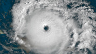
NARRATOR: And third, hurricanes need moisture throughout the atmosphere. If all these conditions come together, wind speeds within the eyewall of the hurricane can rapidly rise.
JEFF DONNELLY: They become the most powerful storms on the planet.
NARRATOR: On a scale of 1 to 5 a major hurricane is a Category 3 storm or above, with wind speeds of 111 miles an hour or greater.
JEFF DONNELLY: You could probably go outside and walk around in 75-miles-an-hour winds. I wouldn't recommend it; there's going to be things flying through the air. If it was a Cat 3 or 4 hurricane you're not even going to be able to walk or stand.
MIKE CHENOWETH: Generally, if over half the buildings are knocked down, that's usually a good sign you've got at least a Category 3 storm.
NARRATOR: The deadliest storm ever to hit the United States was a Category 4 in Galveston, Texas, in 1900, with estimates up to 12,000 dead. Category 5 storms are the most powerful hurricanes of all, with wind speeds over 156 miles an hour.
KERRY EMANUEL: There are very few structures, boats, buildings, cars that can withstand the force of a Category 5 hurricane.
NARRATOR: As wind speeds increase, their destructive power grows even faster.
JEFF DONNELLY: It's not a vertilinear change, it's actually exponential, so the wind is able to do a lot more work.
KERRY EMANUEL: If you double the wind speed, you increase the destruction by at least a factor of eight.
NARRATOR: So, a Category 5 hurricane is at least eight times more destructive than a Category 1. And recent history reveals the extreme destructiveness of these Category 5 storms.
In 2017, Hurricane Maria wrecked power and water systems across most of Puerto Rico. Estimates put the damage at over 90 billion dollars. In 1969, Camille blasted Mississippi, flattening hundreds of miles of coastline. And in 1935, one of the most intense hurricanes ever to hit the United States, the Great Labor Day Hurricane, ripped through the Florida Keys, killing over 400 people.
But according to climatologist Mike Chenoweth, the Great Hurricane of 1780 devastated a wider area and left thousands more people dead than any of these modern Category 5 storms. And he's found detailed, eyewitness accounts that reveal another reason why this unusually large and slow-moving storm was so destructive: its power didn't come from the wind alone.
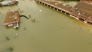
Another devastating force in a tropical storm is the water, an intense surge from the sea, known as "storm surge." This is what killed most people when Typhoon Haiyan slammed into the Philippines in 2013. In the Philippines, more than 60 percent of the population lives within a mile of the water. One of the most powerful storms ever to strike land, Haiyan's wind speeds reached 195 miles per hour, as it moved slowly across the islands.
MARSHALL SHEPHERD: You have the wind driving this water towards the coast. As the storm is approaching landfall, it's going from deeper water to more shallow water. Many people lost their lives in that storm because of the surge.
NARRATOR: Along any coastline, tsunami-like waves, pushed onshore by the hurricane winds, can threaten lives and property.
KERRY EMANUEL: And what you see is a wall of water that just wipes out the neighboring houses and trees and everything before it.
MARSHALL SHEPHERD: And in some cases, this storm surge can be 10 to 20 feet high, and anything within several feet to up to a mile or so of the coastline can essentially be wiped out.
KERRY EMANUEL: Anybody that's told to evacuate because of the danger of a storm surge, they should not think twice about it. Just go.
NARRATOR: Every year, millions of people in the U.S., Central America, and the Caribbean face the threat of hurricane storm surge. And it's storm surge that likely caused much of the destruction in Barbados in 1780.
MIKE CHENOWETH: Suddenly, these massive storm surges came which carry this incredible force with them and devastated the city.
NARRATOR: Along the shore on Barbados, Wayne Neely is hunting for physical evidence of the storm surge in 1780. This is Fort Charles, just outside the capital, Bridgetown. It was entirely rebuilt after the 1780 hurricane completely destroyed the original.
WAYNE NEELY: In 1780, before the hurricane, the fort itself was a massive structure. The walls were much higher and were three- to four-feet thick. The size was immense. For the walls to be destroyed from that hurricane, it had to be a catastrophic storm.
NARRATOR: The records describe an unusually high storm surge, over 25 feet. Eyewitness accounts tell us the hurricane swept heavy cannons 140 yards inland.
WAYNE NEELY: Nothing stood in place. It devastated this fort, it destroyed every house in Barbados, and it devastated the Caribbean.
MIKE CHENOWETH: We had entire fortresses and batteries of war, you know, just totally swept away.
NARRATOR: The scale of destruction reveals the extreme impact of the 1780 hurricane. And now, drawing together all the clues, it's possible to recreate what happened.
On the night of October 9th, 1780, the Great Hurricane approaches Barbados from the southeast. The storm is over 300 miles across. On October 10th, winds and rains lashed the island. Finally, as the eyewall approaches land, the huge winds push up a storm surge 25 feet high. It slams into the coast and inundates the land.
Ravaging the island for over eight hours, it leaves more than 4,000 dead and goes on to claim a total of 22,000 lives, across the Caribbean. The Great Hurricane of 1780 shows how devastating a hurricane can be in an exposed low-lying landscape. Mike Chenoweth believes its destructiveness was unparalleled.
MIKE CHENOWETH: We haven't had a storm like that since, so we're talking about something that's happened only once in 400 years.
NARRATOR: But what are the chances of it happening again?
MIKE CHENOWETH: We don't know how far back something similar might have happened, and we certainly don't know what that possibility in the future is.
NARRATOR: Major hurricanes, of Category 3 and above, are not common events. On average, one makes landfall in the United States every two years. And Category 4 and 5 hurricanes are even less frequent.
KERRY EMANUEL: Category 5 hurricanes are very rare, there are far and far more Category 1s than Category 5s.
NARRATOR: But now, with the buildup of greenhouse gases in our atmosphere, from burning fossil fuels, our climate is changing. So many scientists, like Kerry Emanuel, are predicting that intense hurricanes will become more frequent.
But it's a challenging problem. Today, scientists rely on complex weather data from satellites and aircraft to create computer simulations that can help them make predictions. But this kind of precise data only goes back a few decades.
KERRY EMANUEL: We have reasonably accurate data going back only to about 1970. And if you go back in time, we don't have the satellites. And then, if you go back before the 1940s, we don't have aircraft.
NARRATOR: There just isn't enough modern data to discern patterns in hurricane behavior. Better data about hurricanes in the past would be valuable.
MARSHALL SHEPHERD: If we have understanding of the activity, the intensity, the frequency of storms a thousand, 2,000 years ago, then that gives us better confidence in our ability to assess what hurricanes are doing now and in the future.
NARRATOR: But extracting clues about what hurricanes were doing thousands of years ago, well before detailed historic records, requires some very clever detective work, and some of it needs to be done at sea.
Oceanographer Jeff Donnelly is looking for evidence of ancient hurricanes on the seafloor. His search has brought him over 1,200 miles west of Barbados, to Jamaica. This is Discovery Bay, on the northern coast. Jeff and his team want to expand our understanding of hurricanes by exploring the deep past.
JEFF DONNELLY: We're looking into the sediments to, sort of, find these long-term records, to extend our knowledge back thousands of years.
NARRATOR: Jeff focuses on one part of the bay, next to a reef, too shallow for the research vessel Atlantis. The only way to get there is by building a raft and towing it out to position.
Their target: a blue hole, a natural sinkhole created in the limestone rock. Jeff is interested in the sediments trapped at the bottom of this hole.
JEFF DONNELLY: The blue hole is really a good recorder of hurricanes, so it's sort of a nice time capsule, the sediment can go in, but it never can come back out.
NARRATOR: On calm days fine-grained silt and sand drift into the hole and accumulate over time. But the violent force of a major hurricane propels a different kind of debris into the hole.
JEFF DONNELLY: When a hurricane will hit, you'll get really strong winds, big waves, storm surge, that all sort of comes up over the reef here. And there are really strong currents associated with that, that will tear up pieces of coral that transports sand into the blue hole.
NARRATOR: The more intense the hurricane, the larger the pieces of coral and sand the waves transport. And over thousands of years, this sediment builds up as layers inside the blue hole. The deeper the layers are, the further back in time they were laid down.
The team lowers a hollow tube, vibrates it into the sediments, and retrieves the sample trapped inside.
Back onboard Atlantis, Donnelly cuts into the core.
JEFF DONNELLY: So, we basically can start at the top—you know this might be what's depositing today—and then you go back further in time, as you go down the core.
NARRATOR: It's mostly fine, silty sand, but Jeff spots one sediment layer that's different.
JEFF DONNELLY: When you get down to the bottom, this interval here, and there's really big bits of shell and coral fragments in there.
NARRATOR: Washing and sieving the sample reveals larger pieces of coral mixed up in the sand.
JEFF DONNELLY: It's quite coarse, compared to the rest of the core, but this was all that material that was ripped up and washed into this basin.
NARRATOR: To Jeff, the coarseness of the sediments is clear evidence of powerful waves, most likely driven by a major hurricane, striking here sometime in the past.
JEFF DONNELLY: You'd have to have a quite a high energy event to be moving this kind of sediment from the barrier reef into that blue hole. 15 foot waves, it's something like an intense hurricane strike.
NARRATOR: By retrieving organic materials washed in with the storm, like twigs and leaves that contain carbon, Jeff is able to radiocarbon date these coarser layers. It'll take months to know for sure when this hurricane struck, but he's dated layers from cores taken from sites all across the Caribbean.
JEFF DONNELLY: So, this is a piece of a sediment core that we took in the Bahamas. This particular section dates to the 18th Century. See these light bands here, here and here are these hurricane event beds. They're much coarser than the sediment around them. You can really feel the grit between your fingers.
NARRATOR: And he's finding that the most recent layers exactly match up with the dates of modern hurricanes.
JEFF DONNELLY: When you start coming into it, you know, with a healthy level of skepticism, when all the storms you expect to find end up being there…
NARRATOR: That gives him confidence that his technique is valid. And now he's finding evidence of hurricanes long before historic records began.
JEFF DONNELLY: At present, we've been able to go back about 2,000 years at most sites. Every time we find a layer that dates to before 1600, 1700 A.D., we're finding an event that we never knew occurred.
NARRATOR: By plotting the dates of major hurricanes, back 1,400 years into the past, Jeff sees a pattern emerge. For the first 700 years, during the height of Maya civilization and as the Vikings were colonizing Greenland, it appears powerful hurricanes were more frequent than today.
JEFF DONNELLY: Not necessarily any more intense than the ones we've experienced today, they just occurred much more frequently.
NARRATOR: Then, over the next 700 years, during the Renaissance in Europe, and as European settlers were arriving in the Americas, the record shows a marked decrease.
JEFF DONNELLY: And then, suddenly, it shuts down.
NARRATOR: The Great Hurricane of 1780 falls in the period where there appear to have been far fewer major hurricanes, making it even more unusual.
So, what caused this decline in hurricane activity beginning about 700 years ago? Jeff suspects it might be partly due to trends in sea surface temperature. And it turns out there's a way to recover ocean temperature data from the remains of tiny animals.
JEFF DONNELLY: We can find out about sea surface temperatures in the past by looking at these fossil corals.
NARRATOR: Corals build up giant colonies that can last for thousands of years. Cores, drilled out from deep inside their structures, reveal layers of growth.
JEFF DONNELLY: These corals grow almost like trees. So, each year, it puts on a new band of growth, and you can actually count back in time.
NARRATOR: While forming their skeletons, corals absorb oxygen from the seawater. Oxygen comes in two forms: oxygen-16 has eight protons and eight neutrons in its nucleus, but oxygen-18 has two extra neutrons and is more abundant in the ocean when temperatures are colder.
By measuring the ratio of these two forms of oxygen in the layers of a coral skeleton, scientists can calculate relative ocean temperatures over many thousands of years.
JEFF DONNELLY: Using corals to reconstruct sea surface temperatures is really precise. We're able to reconstruct it right down to the year.
NARRATOR: Plotting sea surface temperature for the Caribbean over the last 1,400 years also reveals a trend: the first 700 years look generally warmer than the next 700 years.
The results match known historical and scientific records that chart a changing climate, from an era known today as the "Medieval Warm Period," to a cooler period known as the "Little Ice Age." And when Jeff compares sea surface temperatures to his graph of hurricane activity it appears that in the past, whenever the sea surface was warmer there were more major hurricanes.
JEFF DONNELLY: There are a whole variety of factors that can influence tropical cyclone activity or hurricane activity, but it's clear that there is this interaction between sea surface temperatures and hurricanes.
NARRATOR: The pattern seems to fit what is known about hurricane formation.
JEFF MASTERS (Weather Underground): Well, the more energy available to power a storm, it makes sense that the storms are going to potentially get stronger.
NARRATOR: But these findings present a puzzle. 1780, the year of the Great Hurricane, falls in the generally colder period of the Little Ice Age.
JEFF DONNELLY: It appears, at first flush, to be quite an anomaly that this 1780 season, and actually that a couple of decades around it, are actually one of the most active intervals.
NARRATOR: But as Jeff looked more closely at the sea surface temperatures, he was able to detect a brief but noticeable spike in the decades around 1780. And cool temperatures in the atmosphere above with warm ocean water below is a known ingredient for hurricane formation.
KERRY EMANUEL: And whenever you have two bodies of very different temperatures, you can create a lot of energy that way.
JEFF DONNELLY: So, that might explain why, in the middle of the Little Ice Age, we see, you know, an increase in hurricane activity.
NARRATOR: Jeff's work linking hurricane events to ocean temperatures could provide an explanation for the intensity of the 1780 hurricane. And this research could sound a warning for our future, because modern data reveals that the sea surface temperature of the Atlantic is now higher than it was a thousand years ago and is still rising.
JEFF DONNELLY: We're actually warmer than any point of the last millennium, you know, a fraction of a degree at this stage, but the projections are that that's going to continue. Not only is it warmer, but it's increasing faster, at a faster rate than we've seen over the entire record.
NARRATOR: As a result, will we see major hurricanes becoming more frequent?
JEFF DONNELLY: We're likely to go back into one of those sort of intervals where we're getting lots more intense hurricane strikes.
NARRATOR: The temperature of our oceans is warming; greenhouse gases, like carbon dioxide, generated by burning fossil fuels, are building up in our atmosphere. These insulate our planet, holding in more of the sun's heat, causing the oceans to warm more quickly than we've detected in the past.
KERRY EMANUEL: The problem, right now, is that the rate at which we're pushing the climate system is very fast compared to anything that's happened in a very, very long time.
NARRATOR: Whether this warming climate means there will be more Atlantic hurricanes is still an open question. But there is a growing agreement that the hurricanes that do hit will be stronger.
KERRY EMANUEL: There is a pretty strong consensus that as the planet continues to warm, we're going to see a greater incidence of the high category hurricanes in most places.
MARSHALL SHEPHERD: We believe that there should be more intense storms. Perhaps not as many of them are happening, but when they do, they'll be stronger.
NARRATOR: So, can scientists predict where these strong hurricanes will strike?
Amy Frappier, who studies ancient climates, has found an ingenious way to look into the past for answers. Compared to the last four centuries, she's finding that Atlantic hurricanes are on the move, likely heading towards the big coastal cities of the eastern United States.
The evidence comes not from beneath the waves, but from caves under the ground. Locked inside stalagmites, like these, are the chemical traces of hurricanes from thousands of years ago.
AMY FRAPPIER: So, here's a stalagmite that we collected from Belize, where we know hurricanes have been part of the weather.
NARRATOR: Rainwater that seeps through the ground above a cave dissolves minerals from the surrounding rock. Then, as it falls, drop by drop, from the ceiling, it leaves a little bit of this mineral behind and a chemical signature of the rainwater itself. This forms stalagmites that, over the years, grow upwards from the cave floor.
Back in her lab, Amy slices stalagmites open and polishes the surfaces. This reveals a series of distinct layers.
AMY FRAPPIER: You can see that there's this whole history in here about what's happened over time. In this one, it's got lots of different changes in color and texture as we go from the older part to the younger part at the top.
NARRATOR: Hunting for the chemical traces of a hurricane in these layers is possible, because rain from hurricanes is chemically different from rain during ordinary storms; again a result thanks to the difference between oxygen-16 and oxygen-18, which has two extra neutrons in its nucleus. In an ordinary storm, raindrops evaporate slightly as they fall. The lighter oxygen-16 evaporates more readily, changing the proportions in rain hitting the ground.
But in a hurricane, the air is so humid that there is very little evaporation. This means that in hurricane rain there's more oxygen-16 than in weaker, short-lived rainstorms.
AMY FRAPPIER: Whenever we see that light oxygen signature, we know that that is a fingerprint for a past hurricane.
NARRATOR: To find this chemical signature, Amy isolates individual layers in the polished stalagmite, then drills out a minute sample as dust. A mass spectrometer can read out the chemical traces locked inside the dust, and it reveals which layers are richer in light oxygen, the signature of hurricane rain.
The results are so accurate, they allow Amy to tell if a hurricane has hit in any given year, thousands of years in the past.
AMY FRAPPIER: The level of detail is just unprecedented. We can see the difference between years with a storm strike in Belize and years without a storm strike in Belize.
NARRATOR: With data from caves across the Caribbean, the evidence suggests that the paths of Atlantic hurricanes appear to be changing over time.
AMY FRAPPIER: We're starting to be able to have enough data that we can see, not only overall patterns of storm activity, but also changes in storm tracks.
NARRATOR: Over a 450-year period, the average track of hurricanes has been moving ever closer to the continental United States.
AMY FRAPPIER: Four-hundred years ago, the storm strikes were clustered in the western Caribbean, around Central America, and now the storm strikes seem to be happening much more frequently around the U.S. East Coast.
NARRATOR: It's a trend that Amy is still exploring, but based on satellite data, Kerry Emanuel has come to a similar conclusion.
KERRY EMANUEL: We've discovered that, over the last 35 years, the latitude at which tropical cyclones reach their peak intensity has been shifting away from the Equator, at a rate of about 35 miles per decade.
NARRATOR: Kerry thinks that climate change is driving the recent shift.
KERRY EMANUEL: What we see, when we look at global warming, is that the fastest warming is occurring in the Arctic. Hurricanes like warm waters, and so they're shifting toward the poles.
NARRATOR: In just 30 years, that's over 100 miles closer to densely populated areas of the United States, along the Eastern seaboard.
The last major storm to hit the northeast coast was megastorm Sandy, in October 2012. After leaving a trail of destruction in the Caribbean, Sandy approaches the New York-New Jersey coastline.
Though most of the Atlantic gets colder as you move north, Sandy feeds off a ribbon of warm water that keeps it alive, the Gulf Stream. This is a circulating current that pumps warm water from the Gulf of Mexico, up and across the Atlantic. By the time Sandy strikes, on October 29th, it's been downgraded from a Category 2 hurricane to a Category 1 storm. But as Sandy combines with another North Atlantic storm system, it hits with catastrophic impact.
A 14-foot storm surge races into New York City, flooding streets, tunnels and subways, and shorting out electrical transmission lines. Across New York and New Jersey the storm leaves 60 people dead, damages 650,000 homes and causes over $70-billion in damage.
WOMAN (New Jersey resident in the aftermath of Sandy): It's just complete devastation. And, you know, my parents have lived here for 40 years, and it's unbelievable.
NARRATOR: Superstorm Sandy was massively large and hit a densely populated area. Its powerful storm surge did most of the damage, but its winds were not especially strong.
MARSHALL SHEPHERD: I think many people would be surprised to know that Hurricane Sandy, at the time it was impacting New York and New Jersey, was not considered a major hurricane.
NARRATOR: Imagine if it had been a Category 3 or higher. It has happened before. The strongest recorded hurricane to strike this coast hit nearly 200 years ago. It is known in historical records as the 1821 Norfolk, Long Island hurricane, and is now thought to have come ashore as a Category 4 storm, far more intense and extensive than Sandy. Experts estimate that if this storm struck today it would cause over $100-billion dollars in damage.
MARSHALL SHEPHERD: Imagine a Category 4 storm impacting New York: the, the flooding, the storm surge, the winds associated with that. Cities such as New York need to be prepared for this type of threat.
NARRATOR: Many factors can affect hurricane formation, but as the climate warms, the threat of major hurricanes heading up from the Caribbean, impacting the southern states and striking the northeast coast is one that climate scientists are taking seriously.
And they're highlighting a less well-known danger of global warming, one that will make hurricanes even more destructive. Warmer oceans cause water volume to expand; at the same time, glaciers are melting: the result, sea level around the world is rising.
MARSHALL SHEPHERD: If you look at some of the more recent data, not only is it rising in more recent decades, it's rising at a faster rate.
KERRY EMANUEL: The best guess now is that if we don't curb emissions we'll be up a meter, or three feet, by the end of the century.
NARRATOR: The rising sea level increases the risk of damaging storm surge.
JEFF MASTERS: When that storm surge rides up on top of higher sea levels, then it causes a lot more destruction.
NARRATOR: Today, millions of people in coastal and island communities are at risk.
KERRY EMANUEL: With all of this infrastructure very close to sea level, we're much more vulnerable to much smaller changes.
NARRATOR: To better understand our future, scientists are looking into the past, and what they're finding leads some to predict that a hurricane as deadly as the Great Storm of 1780, with its huge storm surges, will likely strike again.
JEFF MASTERS: We're going to see another hurricane like the Great Hurricane of 1780 again on our shores, and it's going to hit land at full intensity.
MIKE CHENOWETH: It's happened once before, so there's no reason to not expect it to happen again.
NARRATOR: While there is no way to predict what lies ahead, with certainty, the evidence suggests we need to be prepared to face more killer storms in the future.
Broadcast Credits
Delroy Johnson
Laura Mayne
Paul Satchell
AP Archive
Axiom Images
BBC Motion Gallery/Getty Images
Biopixel Pty Ltd
Critical Past
Earth Uncut
Getty Images
Hurricane Activity Data: Kathryn Denommee
John Mattiuzzi
John Sochacki
Live Storms Media
Mackanaky Steevens Magloire
Marc Castells
Médecins Sans Frontières
MOLA
NASA
National Hurricane Center in Miami, Florida
NOAA
Plan International
POND5
RT Doc
----
Sea Surface Temperature Data: Michael E. Mann
Shutterstock
State Archives of Florida
The Antiqua and Barbuda Tourism Authority
The National Archives
The U.S. National Archives
Ultimate Chase
Jeffrey P. Donnelly
Gregory J Holland
Phil Klotzbach
Thomas Knutson
Jim Kossin
John Luker
Musikvergnuegen, Inc.
Rob Morsberger
Eddie Ward
A NOVA Production by Blink Entertainment Ltd. for WGBH Boston in association Channel 4 and SBS-TV Australia with the support of Creative Europe – MEDIA Programme of the European Union
© 2017 Blink Entertainment Ltd
All rights reserved
Additional Material © 2017 WGBH Educational Foundation
All rights reserved
Original funding for this program was provided by Draper, 23andMe, the David H. Koch Fund for Science and the Corporation for Public Broadcasting.
IMAGE:
- Image credit (hurricane storm surge)
- Courtesy NOAA, Jim Edds/Extremestorms.com
Participants
- Mike Chenoweth
- Climate Historian
- Jeff Donnelly
- Woods Hole Oceanographic Institution
- Kerry Emanuel
- Massachusetts Institute of Technology
- Amy Frappier
- Skidmore College
- Jeff Masters
- Weather Underground
- Reg Murphy
- International Association for Caribbean Archaeology
- Wayne Neely
- Nassau Department of Meteorology
- Marshall Shepherd
- University of Georgia
Preview | 0:30
Full Program | 53:04
Full program available for streaming through
Watch Online
Full program available
Soon

Related Links
-
Killer Floods
Discover how colossal floods transformed the ancient landscape.
-
Killer Volcanoes
Scientists hunt for a mega-eruption that plunged medieval Earth into a deep freeze.
-
2017 Hurricane Season Explained
After a quiet start, August and September quickly became filled with violent storms. What drove the change?
-
What Makes a Hurricane?
Hurricanes bring wind, rain, and destruction—but how do they form?
-
Hurricane Power
Your average hurricane releases enough energy to power the world 200 times over. Go figure.
-
The Coriolis Effect
Why do storms spin as they travel?
-

Inside the Megastorm
Watch as Megastorm Sandy unfolds, and explore what made it so much more devastating than other hurricanes.
-

Climate Change and Sandy
A climate scientist suggests that rapid warming in the Arctic helped create October's "superstorm."
-

Megastorm Aftermath
How can cities prepare for rising seas and raging storms?
-
Why Did Houston Flood?
Hurricane Harvey broke continental U.S. records. Here's how cities can be better prepared.
-
Hurricanes and Climate Change
Why climate change is making hurricanes more dangerous.
-
Quiz: Hurricanes
Five questions that will separate the hurricane know-it-alls from the rest of us


National corporate funding for NOVA is provided by Draper. Major funding for NOVA is provided by the David H. Koch Fund for Science, the Corporation for Public Broadcasting, and PBS viewers.