
Killer Volcanoes
Scientists hunt for a mega-eruption that plunged medieval Earth into a deep freeze. Airing October 25, 2017 at 9 pm on PBS Aired October 25, 2017 on PBS

Program Description
Transcript
Killer Volcanoes
PBS Airdate: October 25, 2017
NARRATOR: Our planet is capable of unleashing extreme chaos. Volcanoes, earthquakes, hurricanes and floods can cause untold devastation. We may think we've seen the worst Mother Nature can throw at us, but scientists struggling to understand these disasters are discovering evidence that even more extreme events have struck in the past.
JEAN-CHRISTOPHE KOMOROWSKI (Institut de Physique du Globe de Paris): So, this is about 13 times more powerful than the Pompeii eruption.
NARRATOR: They're uncovering clues that the worst catastrophes in history could strike again.
Nearly a thousand years ago, a disaster shook the world…
JEAN-CHRISTOPHE KOMOROWSKI: This is one of the largest eruptions in the last 10,000 years.
NARRATOR: …a volcano, so powerful it chilled the entire planet, but where was it?
NELIA DUNBAR (New Mexico Bureau of Geology & Mineral Resources): No one knew the source of the eruption.
NARRATOR: The clues are here, buried and hidden all around the world. Now, scientists come together to scour our volatile earth, to solve the mystery of Killer Volcanoes, right now, on NOVA.
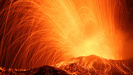
Of all the forces of nature, volcanoes are among the most dangerous. They have the power to kill millions and disrupt the fabric of modern life.
JEAN-CHRISTOPHE KOMOROWSKI: Volcanoes can have a global impact.
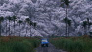
NARRATOR: Today, there are more than 1,500 active volcanoes on Earth. About 50 erupt every year. Many are well known, like Vesuvius, in Italy, and Mount St. Helens, in Washington State, but could there be other slumbering giants that we have never heard of? Volcanoes that were once even more powerful and destructive than today's monsters? That's what a series of clues is suggesting. Scientists working across the world have begun to find evidence of a cataclysmic event, a mysterious eruption that could have been one of the largest in human history, and the trail starts in a very unexpected place.
Here, in the heart of London, archaeologists uncover a surprise. While excavating a medieval cemetery, they happened upon a series of mass graves, on the edges of the burial ground. Over 4,000 men, women and children, packed into large pits. The cause of death was not obvious. So, what killed so many people? And why were they all buried together?
DON WALKER (Museum of London Archaeology): When we find mass burial pits, we know that there's been a lot of people dying very quickly, and something has gone very wrong.
NARRATOR: As a first step to identifying the killer, archaeologist Don Walker and his team conducted radiocarbon tests to find out how long ago they died. The hope was that they could tie their deaths to some historical event, but what they found merely deepened the mystery.
The victims all died around 1250 in the Common Era. That ruled out one of the most notorious mass killers of the past, the Black Death, which ravaged Europe about a century later, in 1348. So, what could have caused this mass killing?
Don Walker heads to the British Library, to consult ancient historical records from the period. This manuscript is a history of England, over 750 years old. It was written in Latin by a monk named Matthew Paris. Among these chronicles, one account stands out, a description of bitterly cold weather around London in the spring and early summer of 1258, that kills crops and livestock and leads to a deadly famine.
DON WALKER: It says, "Owing to the scarcity of wheat, a large number of poor people died and dead bodies were found in all directions, swollen and livid."
NARRATOR: Then Walker discovers a description that seems to match the discovery of the mass graves.
DON WALKER: "When several corpses were found, large and spacious holes were dug in the cemeteries and a great many bodies were laid in them together."
And of course, as soon as I saw that, I got very excited, because it's exactly the kind of thing that we found at St. Mary Spital, where they were digging these huge pits.
NARRATOR: According to this text, the famine killed over 15,000 people in London. That's 30 percent of the city's population, at the time.
DON WALKER: You're talking about something that was perhaps nearly as deadly as the Black Death.
NARRATOR: And possibly as widespread, too. Other sources reveal the far-reaching impact of the extreme weather and its disastrous effect on crops.
CLIVE OPPENHEIMER (University of Cambridge): There are various records from this period—1258, 1259, 1260—in various parts of Europe and as far as Japan, that do attest to extreme impacts in terms of famine, in particular.
NARRATOR: Something devastating was plunging much of the Northern Hemisphere in a pattern of bitter winters and summers blighted by torrential rain.
DON WALKER: We thought perhaps this was something to do with some catastrophic event.
NARRATOR: Only one type of natural disaster could have such a widespread impact on the climate: a massive volcanic eruption. But which volcano was the culprit? The closest volcanoes are a thousand miles away in Iceland.
In 2010, when a volcano known as Eyja erupted, it sent an ash cloud over Europe that disrupted air travel for weeks, stranding people all over the world. And historical records reveal that in 1783, eruptions from the Laki volcano caused mass deaths across Europe. It seems like an Icelandic volcano could be to blame for the mysterious 13th century event. But Walker came across another possibility. He became intrigued by one of the most massive eruptions in recorded history, even though it occurred just 200 years ago and was located much farther away: Mount Tambora, in Indonesia.
In April 1815, eyewitness accounts record that Mount Tambora erupted explosively.
JEAN-CHRISTOPHE KOMOROWSKI: And this is one of the largest eruptions of the last 10,000 years.
NARRATOR: It's estimated over 60,000 people died in the shadow of this volcano. But the eruption had an even more far-reaching impact. In northern Europe and North America, the year after the eruption, 1816, is known as the "year without a summer." In New York State, it snowed in June. In Europe, cold weather led to the worst famine for a century.
CLIVE OPPENHEIMER: The climate change caused agricultural failures, poor harvests; it pushed up grain prices, with many people perishing from malnourishment.
NARRATOR: So, perhaps another powerful eruption could have caused the year without a summer in 1258.
DON WALKER: We began to think that perhaps this might be something to do with what had happened back in the 13th century; perhaps this was why the people starved.
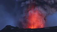
NARRATOR: But to pinpoint the location of the mysterious volcano, they needed to know more about its size and type of eruption. They look at one of the largest volcanic events in recent memory, the 1991 eruption of Mount Pinatubo in the Philippines.
Unlike volcanoes that erupt by pouring out rivers of molten lava over a long period of time, Pinatubo erupted suddenly and violently, when water and gases trapped inside the magma exploded with tremendous force, shattering the rock into millions of tiny particles and sending them high into the atmosphere. Explosive eruptions like this are the most dangerous of all.
Pinatubo killed 847 people, locally, and left over 200,000 homeless. But, as with the other big Indonesian volcano, Mount Tambora, this eruption also had far-reaching effects. NASA's satellites were able to monitor the eruption. Pinatubo blasted out one-cubic-mile of superheated ash, but it also ejected hundreds of millions of tons of volcanic gases, in a plume 22 miles high.
JEAN-CHRISTOPHE KOMOROWSKI: The ash and the gases are dispersed through the atmosphere by the wind, and they can travel thousands of kilometers, tens of thousands of kilometers.
NARRATOR: But unlike heavy ash that soon falls out of the atmosphere, the lightweight gases persist for much longer.
JEAN-CHRISTOPHE KOMOROWSKI: The most impactful gases are the sulfur-rich gases. And those gases will form little droplets of sulfuric acid in a large cloud.
NARRATOR: The tiny drops of sulfuric acid are called "aerosols," and in a large cloud, high in the upper atmosphere, these aerosols caused enough sunlight to reflect out into space to cool the planet. The satellite data revealed that this sulfuric acid mist had a much more dramatic impact than the ash. It blocked enough sunlight to cool the entire planet by one degree Fahrenheit for two years.
CLIVE OPPENHEIMER: That doesn't sound very much, but it actually masks much stronger regional variations, and that translates into real impact on the ground in terms of crop yields.
NARRATOR: In 1258, the temperature drop was much greater than caused by Pinatubo. This suggests that whatever triggered this medieval disaster could have been much bigger.
FRANCK LAVIGNE (University of Paris 1 Panthéon Sorbonne): That indicated that a big event occurred somewhere in, in the world, but there was no record of a massive volcanic eruption.
CLIVE OPPENHEIMER: For volcanologists, it was the biggest mystery for us.
NARRATOR: So where could the culprit volcano have been? And, after more than 750 years, could this killer volcano be found? It seemed the trail had gone cold, until a clue appeared frozen in the polar ice.
About a thousand miles from the North Pole, researchers for the Greenland Ice Sheet Project are taking core samples from deep in the ice. This ice sheet was built, layer by layer, as snowfall accumulated over 130,000 years. The deeper into the ice the scientists drill, the farther back in time they can look.
The samples arrive for analysis at the Desert Research Institute, in Nevada. Glaciologists Nelia Dunbar and Joe McConnell are preparing to analyze an Arctic ice core sample that contains snowfall from the mid-thirteenth century. The core comes from 1,000 feet below the surface of the ice sheet. They will be looking for sulfuric acid, evidence of an intense eruption.
NELIA DUNBAR: If there were a big volcanic eruption that produced a lot of sulfur, that sulfur should be preserved in this ice. And that's what we're interested in studying.
Where is this from, and what's the age of it?
JOE MCCONNELL (Desert Research Institute): So, this piece is from around 1250, 1255 A.D.
NELIA DUNBAR: Okay.
JOE MCCONNELL: This represents about three years. So, this is roughly one year, roughly one year and roughly one year.
NELIA DUNBAR: These ice cores hold an incredible record of past climate. In between the snow crystals, are little pockets of atmosphere that are little time capsules that represent the composition of the atmosphere at the time the snow fell. Over time, more snow will fall on the ice sheet and that record is locked in.
JOE MCCONNELL: Up to the right, and then up to there.
NARRATOR: But to unlock the record, scientists have to destroy it, inch by inch.
JOE MCCONNELL: Okay, so now we're ready to start the analysis.
NELIA DUNBAR: Okay.
NARRATOR: As each layer of ice melts down, the meltwater passes through a mass spectrometer. It's like a time machine that reads out the chemicals that were in the atmosphere hundreds of years ago. The results start to come through, and the team immediately sees a telltale spike.
JOE MCCONNELL: So, we're seeing the responses come up on all the various instruments, right now. So this would be 1258, and you can see the acid, now, has just skyrocketed: a huge increase in sulfur. So, it's certainly pointing to volcanism.
NELIA DUNBAR: Okay, so that must have been a really big volcanic event.
JOE MCCONNELL: Yeah, absolutely huge.
NARRATOR: The sulfur locked inside the 1258 ice layer tells the story of a powerful volcanic eruption. And though the sulfur was washed out of the atmosphere in rain and snow in 1258, the eruption itself likely occurred the year before.
JOE MCCONNELL: Now, keep in mind that it takes a while for the sulfur to make it from the volcano, through the atmosphere and be deposited on the ice sheet.
NELIA DUNBAR: Mm-hm.
JOE MCCONNELL: And so this event, it probably occurred in, in maybe mid- to late 1257.
NARRATOR: And the amount of sulfur ejected by this eruption was vast by comparison with that produced by the other known eruptions captured in the ice cores.
JOE MCCONNELL: Here's the 1257. Of that, that we just measured again in this, in this new ice core, we can see that its huge. When you compare it to Tambora, here, in 1815, its, you know, something like more than twice as big. So, this is a really, really big event.
NELIA DUNBAR: Mm-hm.
JOE MCCONNELL: And, at least in this composite, it's the biggest event over the last 2,000 years, very clearly.
NELIA DUNBAR: Okay, mm-hm.
NARRATOR: So, this eruption seems to have been large enough to account for the freak climate disaster across the northern hemisphere in 1258, including London's deadly famine.
CLIVE OPPENHEIMER: It was hard to really pin down one event and say, "This was the result of a volcanic eruption," but I think, in this case, the evidence is quite strong.
DON WALKER: You can imagine living in medieval London. You know that you haven't got enough food to live, your crops are failing, the weather's very bad, but you'd have no idea the true cause of what was going on.
NARRATOR: The true cause was that somewhere on the planet, in 1257, a volcano exploded and blasted its contents, including poisonous gas and ash, high into the atmosphere, where it dimmed the sun for months, if not years. But where was this killer?
NELIA DUNBAR: The mystery that remains is what was the volcano that was responsible for this big volcanic eruption?
NARRATOR: More than 1,500 volcanoes have been active in the last 10,000 years, so pinpointing which of these causes such a massive disruption in 1258 is a huge challenge. The first place to look is a string of volcanoes known as the Pacific Ring of Fire.
The continents we live on ride atop giant tectonic plates made of rock. Where plates collide or slide under each other gives rise to volcanoes, making this one of the most geologically active regions of the world. But the Ring of Fire extends for thousands of miles. How can scientists work out which volcano is the culprit?
In her lab at the New Mexico Bureau of Geology, Nelia Dunbar examines some distinctively shaped mineral particles, lodged in a section of ice from a different Greenland ice core. The particles also date to 1258, when the sulfur concentrations are highest. Could these particles be possible clues to the volcano's identity?
At 50,000-times magnification, it's clear that the mineral particles are actually microscopic pieces of volcanic ash.
NELIA DUNBAR: These particles are smaller than a human hair.
NARRATOR: The ash particles are fragments of shattered pumice, produced when magma cools rapidly during an eruption. And their chemical composition is unique to each volcanic eruption.
NELIA DUNBAR: Just like a human fingerprint allows a suspect to be identified, the chemical composition of an ash layer allows the source volcano to be identified.
NARRATOR: This unique signature didn't match any known volcano. But it did show up in one other surprising place, at the exact opposite end of the world, in ice cores taken from the South Pole. These cores also contained a significant spike in sulfuric acid corresponding to the eruption in 1257. This means that the monster darkened not only the Northern Hemisphere, but the Southern Hemisphere as well, smothering the entire world in a blanket of sulfuric acid.
Climatologist Michael Mills believes the size of this global cloud can help pinpoint the place where the volcano erupted. He uses satellite data to map how clouds of sulfuric acid aerosols disperse around the world.
MICHAEL MILLS (National Center for Atmospheric Research): Let's look at what happens when you have an eruption in the Northern Hemisphere. In 2008, we had several eruptions, and the aerosol stays in the Northern Hemisphere. Now look at what happens when you have an eruption in the Southern Hemisphere: the aerosol spreads and will remain in the Southern Hemisphere.
NARRATOR: But how could an aerosol cloud reach both hemispheres? For that, an eruption has to occur within a narrow band around the middle of the globe.
MICHAEL MILLS: This is Pinatubo in June of 1991, in the Philippines. It starts spreading throughout the tropics, and from there it spreads into the Northern Hemisphere and to the Southern Hemisphere. Within a year after the eruption, the aerosol has covered the globe from pole to pole, affecting temperatures globally.
NARRATOR: The mystery eruption of 1257 also spread a cloud of sulfuric acid over both poles, so, it too must have erupted near the equator. But that still leaves over 700 possible volcanoes as suspects, like Mount Tambora that led to the year without a summer; Krakatoa, that also erupted in Indonesia in 1883; and El Chichon, in Mexico, that erupted in 1982. Any one of hundreds of tropical volcanoes could have caused thousands of deaths on the other side of the planet, but which one? And could it strike again?
CLIVE OPPENHEIMER: It's still a needle in a haystack to find the one volcano, the one eruption that, that triggered all of this, because there are so many volcanoes. Even if you narrow it down to the tropics, where do you start?
NARRATOR: It seemed an impossible mystery to solve, but then a French geographer named Franck Lavigne decided to take it on.
FRANCK LAVIGNE: For me, it looks a bit strange that nobody found this eruption, so I decided to take up the challenge.
NARRATOR: He approaches it as a detective.
FRANCK LAVIGNE: Trying to find the identity of this mystery volcano was like a crime scene, so, we needed to investigate, to look for culprits, to look for clues.
NARRATOR: Volcanologist Jean-Christophe Komorowski joins the investigation.
JEAN-CHRISTOPHE KOMOROWSKI: It's a very large eruption, it's an unknown eruption, so it has to be in a, in a country where there are many, many volcanoes. Most of them, perhaps, have not been studied.
NARRATOR: The team focuses on one particularly active region of the Pacific Ring of Fire: Indonesia, home of the once deadly Mount Tambora, that last erupted in 1815. With 129 active volcanoes, spread over 3,000 miles, Indonesia is the most volcanic country in the tropics. It is also one of the most unstudied and mysterious.
JEAN-CHRISTOPHE KOMOROWSKI: Indonesia: it has the second largest number of active volcanoes in the world.
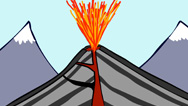
NARRATOR: Indonesia marks the place where two giant tectonic plates collide. Here, one plate dives under the other, in a process called "subduction." At depth, the diving plate releases water, which lowers the melting point of the hot rock above. The rock melts, forming giant bubbles of magma that rise up, forcing their way through the earth's crust, until the magma erupts at the surface.
Today, the most dangerous Indonesian volcano is Mount Merapi, on the island of Java. This volcano erupts explosively every few years, threatening hundreds of thousands of people who live in its shadow.
AGUS BUDI SANTOSO (Centre for Volcanology and Geological Hazard Mitigation): Merapi volcano is considered to be one of the most active volcanoes in the world.
NARRATOR: The last major eruption was in 2010. Four-hundred-thousand people evacuated. Even so, more than 200 died in the avalanches of superheated ash and rock, called "pyroclastic flows." Twenty-thousand were left without homes. The ash produced by Merapi does not match the chemical fingerprint of the ash in the ice cores, but understanding the forces that make this volcano so dangerous sheds light on all of Indonesia's active volcanoes.
So, which one exploded so catastrophically in 1257? Geographer Lavigne hunts through satellite images for large volcanic craters and other telltale signs.
FRANCK LAVIGNE: And one of these clues is a large volume of pumice all around the volcano.
NARRATOR: Pumice, a rough textured rock, is solidified magma, blasted out during explosive eruptions.
JEAN-CHRISTOPHE KOMOROWSKI: When you suddenly depressurize and cool magma that was very rich in gas and it forms this very lightweight, foamy rock, which is pumice.
NARRATOR: It can be a deadly material. When Mount Vesuvius erupted in Italy in 79, the Common Era, it entombed the town and the people of Pompeii in layers of pumice 16 feet deep. Throughout Indonesia today, pumice mines dig out this volcanic material, primarily for use in the construction industry. And the scars left by the quarrying work are so extensive that they're visible from space, making it easy for scientists to pinpoint locations for further investigation.
Journeying to Indonesia, Lavigne works with partners from the government's Geological Agency and Indonesian universities. They visit several volcanoes, with no success. At each site, the pumice is compacted and hard, likely too ancient to have been created during the 1257 eruption.
INDYO PRATOMO (Geological Museum Bandung): (Translated from Indonesian) It seemed older than we had predicted, so, older than the 13th century.
NARRATOR: Then the team sees something intriguing in the satellite images and decides to narrow its search to the island of Lombok, just east of Bali.
FRANCK LAVIGNE: This island is quite a big island, with a very big crater.
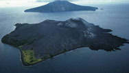
NARRATOR: Stretching four miles across and over two-and-a half thousand feet deep, this giant crater is called a "caldera." It's what remains of a volcanic system known as Mount Rinjani.
JEAN-CHRISTOPHE KOMOROWSKI: When you have a very large explosive eruption, you're left, at the end of the eruption, with a huge hole.
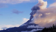
NARRATOR: To the team's expert eyes, it looks like there were not one, but two giant volcanic peaks here in the past. Mount Rinjani itself and a second peak, that once rose above the main part of the caldera. Today, inside this caldera is now a small volcanic cone, Mount Barujari. Surrounded by a rainwater lake, Mount Barujari is the part of the volcanic system that is still active.
In 2015 and 2016, this small cone erupted with enough force to send plumes of ash thousands of feet into the atmosphere, disrupting international flights in the area. It's far too small to be the source of the mystery eruption, but the caldera it sits in is large enough to have been created during a much more powerful eruption.
And all around the Mount Rinjani volcanic system are pumice quarries.
FRANCK LAVIGNE: Everywhere in the island, you can find a pumice quarry.
NARRATOR: Could the pumice in these quarries be dated to help in their investigation?
The team travels to Lombok. And the hunt starts in the shadow of Mount Rinjani, a peak that soars 12,000 feet high. On the island, they join forces with more Indonesian experts.
They head for the quarries identified in the satellite images. And as soon as they arrive, they discover something remarkable: the volcanic pumice deposits are at least 120 feet deep.
FRANCK LAVIGNE: Here we are, looking at the huge volcanic deposit. And that's very rare to find so thick deposit very far away from the summit of the volcano.
NARRATOR: Pompeii, just over five miles from the erupting Mount Vesuvius, was buried under 16 feet of pumice. Here, the deposits of pumice and ash are at least six times thicker, and they are much farther away from Mount Rinjani than Pompeii was from Mount Vesuvius. It's a sign of a giant eruption.
JEAN-CHRISTOPHE KOMOROWSKI: You are dealing with a very massive eruption, much larger than the Pompeii eruption and probably also much larger than the Pinatubo eruption in 1991.
NARRATOR: And it looks to them as though the ash and pumice flowed down from the volcano in vast avalanches.
JEAN-CHRISTOPHE KOMOROWSKI: You can see it's very rich in finer material. It's not pumice falling from a column, raining down, it's an avalanche of incandescent hot volcanic rocks mixed with gases.
FRANCK LAVIGNE: My first impression, when I saw such a huge deposit, was that we have here a very serious candidate for the mystery eruption.
NARRATOR: But is all this pumice from the mystery eruption of 1257?
JEAN-CHRISTOPHE KOMOROWSKI: To confirm that this eruption is the 1257 eruption, we need to try to find charcoal, wood logs that were burned by this eruption, carried by the pyroclastic flow and, and settling here. And we need to take those.
NARRATOR: If they can find burned wood, they can radiocarbon date it, since, unlike pumice, wood contains carbon absorbed from the atmosphere. And by taking samples of the pumice itself, the team hopes to compare its chemistry with the fragments of volcanic ash from the polar ice cores.
But Lavigne still needs more evidence, so he decides to investigate Lombok's past, to see if he can find records of historic eruptions.
Under lock and key, in the museum of Lombok's capital city, Mataram, is an original text, written on dried palm leaves, in an old Javanese script. Called the Babad Lombok, this text is a rare account of Lombok's history.
LALU NAPSIAH (West Nusa Tenggara State Museum): (Translated from Javanese) It chronicles the story of Lombok from prehistoric times to historic times.
NARRATOR: And hidden in this document is a remarkable account that historians have dated to the 13th century.
LALU NAPSIAH: (Translated) "Mount Rinjani avalanched and Mount Samalas collapsed. Rocks flooded down in roars."
FRANCK LAVIGNE: It describes a huge volcanic eruption that occurred in Lombok.
NARRATOR: Lavigne is familiar with Mount Rinjani, mentioned in the text, but not the name of the volcano that's described as collapsing, Mount Samalas.
FRANCK LAVIGNE: This description is absolutely fantastic, because it mentions the name of a new volcano, Mount Samalas. I never heard about this before.
NARRATOR: This remarkable discovery raises a new question: could the giant caldera the team saw on satellite images belong to the unknown Mount Samalas? The text also reveals the scale of the human catastrophe.
FRANCK LAVIGNE: The text in the Babad says these flows destroyed the seat of the kingdom, Pamatan. All houses were destroyed and swept away, floating on the sea and many people die. There is a strong possibility of the remains of this capital still lie preserved beneath the pumice, just like Pompeii.
NARRATOR: The text is a tantalizing clue, but could it just be a myth?
FRANCK LAVIGNE: It made this volcano our chief suspect in our investigations, but to confirm it was the one, we needed scientific proof.
NARRATOR: So the team decides to mount an expedition. To trek into the mountains and hunt for hard evidence at an altitude of 9,000 feet.
From up here, the team can assess the landscape and geology in a way that's impossible from satellite images alone. Exposed in the cliffs are geological layers that allow Jean-Christophe Komorowski to work out the sequence of events that led to what we see today, the giant caldera.
JEAN-CHRISTOPHE KOMOROWSKI: These cliffs are the remains of a very massive volcano.
NARRATOR: And towering over the east side, the remains of Mount Rinjani.
JEAN-CHRISTOPHE KOMOROWSKI: You can see the slopes of Mount Rinjani volcano rising to 3,700 meters. And it was much higher before.
NARRATOR: The scars in the cliffs suggest to Komorowski that half of Mount Rinjani avalanched into the caldera, after it formed.
JEAN-CHRISTOPHE KOMOROWSKI: The formation of the Samalas caldera destabilized Mount Rinjani, which collapsed into the caldera. And this formed this massive sheer cliff, here.
NARRATOR: To the experts, it looks like Mount Samalas once stood next to Mount Rinjani, just as the ancient text describes.
NUGRAHA KARDATINATA (Centre for Volcanology and Geological Hazard Mitigation): (Translated from Indonesian) In fact the latest research found that there was a volcanic mountain called Mount Samalas, which in the end is different than Mount Rinjani.
NARRATOR: By extending the existing slopes of the volcano, experts have reconstructed what Mount Samalas looked like.
JEAN-CHRISTOPHE KOMOROWSKI: Imagine that, before the eruption, you had a huge conical volcano, rising 1.6 kilometer above the rim of this giant hole.
NARRATOR: That's an extra mile in height of volcanic mountain. So, how did several cubic miles of rock disappear and leave an enormous caldera in its place? It all begins with a giant eruption.
JEAN-CHRISTOPHE KOMOROWSKI: And in order to form a caldera, you have to have first a very massive explosive eruption.
NARRATOR: In a magma chamber, far beneath the volcano, the pressure rises and finally cracks open the rock above. Magma blasts upwards. As this chamber empties, it becomes unstable.
JEAN-CHRISTOPHE KOMOROWSKI: This destabilizes the whole volcano on top.
NARRATOR: The roof of this partially empty chamber now cracks under the weight.
JEAN-CHRISTOPHE KOMOROWSKI: And it collapses.
NARRATOR: The entire top of the volcano caves in. Billions of tons of rock disappear, as it falls thousands of feet down into the magma chamber below, forming a giant crater above, the enormous caldera. But that's not the end.
JEAN-CHRISTOPHE KOMOROWSKI: As the volcano collapses on itself, it forms a massive explosive eruption, producing giant pyroclastic flows that sweep down the flanks of the volcano.
NARRATOR: This catastrophic event explains the depth of the pumice deposits in the quarries and closely aligns with the ancient story in the Babad Lombok.
JEAN-CHRISTOPHE KOMOROWSKI: It gives a name to the volcano that existed at the beginning of the eruption, Mount Samalas, and it describes how Mount Samalas collapsed in on itself. Altogether, the description in the Babad matches remarkably what we have found in our field investigations.
FRANCK LAVIGNE: We now know that the Babad was not a legend, but eyewitness accounts.
NARRATOR: If the long-forgotten Mount Samalas was the source of the giant eruption on Lombok, as the evidence suggests, could it also be the mystery eruption of 1257? To answer that definitively, the team still needs more forensic evidence.
CLIVE OPPENHEIMER: It's really critical to get on the ground to look at the actual rocks themselves.
NARRATOR: They take samples of pumice and ash from over 100 different sites, across Lombok and on neighboring islands. They conduct geophysical surveys to measure the depth of the volcanic deposits still buried beneath the ground, and then investigate whether gases from this eruption could have reached high enough into the upper atmosphere to spread globally.
JEAN-CHRISTOPHE KOMOROSKI: To assess the scale of the eruption, we looked at these pumice fragments that were ejected by the eruption column. And the idea is that the further away you find big fragments, it means that these fragments were ejected with a lot of energy and that the eruption column reached very high in the atmosphere.
NARRATOR: In this case, pumice fragments, two inches across, were found 29 miles away, on the nearby island of Sumbawa, allowing the team to calculate that the pumice likely ascended nearly 27 miles high, more than 10 miles higher than the Mount St. Helen's eruption of 1980.
JEAN-CHRISTOPHE KOMOROWSKI: This is one of the highest column heights for explosive eruptions in the last 10,000 years.
NARRATOR: The Mount Samalas eruption was certainly massive enough to cool the entire world. But can scientific tests prove that the pumice was from the mystery 1257 eruption?
In Paris, French volcanologist, Celine Vidal, goes through the samples taken from Indonesia. First, she selects pieces of carbonized wood, found inside the pumice deposits, for radiocarbon dating.
CELINE VIDAL (Institut de Physique du Globe De Paris ): (Translated from French) We analyzed 20 pieces of carbonized wood from sites all across the volcano, and the carbon-14 dating told us that the eruption dated to the second half of the 13th century.
FRANCK LAVIGNE: All the results were consistent with the mystery eruption.
NARRATOR: The dates are in range, but there is one final test. Will the chemical fingerprint of this eruption match the fingerprint in the polar ice cores? At high magnification, Vidal compares the volcanic ash fragments, one from the Antarctic ice core from 1257 and one from the pumice deposits on Lombok.
CELINE VIDAL: (Translated) You can see that the surfaces of the two different particles of ash have the same texture and that their edges are very sharp.
NARRATOR: They appear very similar. But how closely do their chemical fingerprints match?
CELINE VIDAL: (Translated) I add, now, the chemical composition of the ash from Samalas, here, in blue, and one sees that the peaks correspond perfectly. They are comparable to more than 99 percent, and that is really excellent. This allows us to conclude that they are from the same origin.
NARRATOR: Now, there is finally enough evidence to remove all doubt, the mystery killer volcano is here, on Lombok: Mount Samalas, once known and since forgotten.
FRANCK LAVIGNE: The team was very excited by the result.
JEAN-CHRISTOPHE KOMOROWSKI: The source of the 1257 eruption has been a mystery for 30 years, so we were quite excited when we were able to prove that Mount Samalas erupted in 1257.
NARRATOR: The mystery of the massive spike of sulfuric acid in the polar ice cores, the global volcanic winter caused by a cloud of aerosols that blocked the sun, and likely, the thousands of people killed in London in a catastrophic famine, all have been answered. By combining these discoveries with the investigation on the volcano, the team can now unpack the eruption, blow by blow.
JEAN-CHRISTOPHE KOMOROWSKI: The 1257 eruption started with a very explosive, violent eruption from Mount Samalas…
NARRATOR: At its peak, the eruption blasted out one-million tons of material a second.
JEAN-CHRISTOPHE KOMOROWSKI: …and that produced a very tall eruption column of ash and gases and pumice, rising 43 kilometers in elevation.
NARRATOR: Nearly four cubic miles of pumice and ash rise four times higher than the operational altitude of a passenger jet. While the gases remain aloft, most of the pumice and ash then falls back to Earth.
JEAN-CHRISTOPHE KOMOROWSKI: And it produced a rain of pumice over a very vast area.
NARRATOR: It covers an area at least 450 miles across. During the final collapse of the volcano, six cubic miles of pumice and ash form giant pyroclastic flows. Racing down, they reach speeds of over 125 miles an hour, at temperatures of 1,500 degrees Fahrenheit.
JEAN-CHRISTOPHE KOMOROWSKI: They covered the entire landscape of Lombok with thicknesses of five to 50 meters, reaching the sea in many places.
NARRATOR: But even as the dust settles on Lombok, the vast volcanic cloud starts to envelop the entire world, even as far away from the eruption as North America and Europe.
DON WALKER: The fact that we have so many thousands of people buried in these mass pits as a result of this volcanic eruption, just shows us what a global event it was.
NARRATOR: This was possibly the most massive volcanic eruption in recorded history. And it raises a troubling question: could another eruption of this magnitude happen again? It's been 750 years since the giant eruption of Mount Samalas, yet inside its vast caldera, eruptions from Mount Barujari reveal that the volcanic system is still active.
Two-and-a-half-thousand feet below the caldera rim, Komorowski rejoins the team of Indonesian volcanologists, monitoring the active heart of the Samalas/Rinjani volcanic complex.
Using thermal imagery, and making a risky trek to collect lava from the latest eruptions, the Indonesian volcanologists are gaining an ever more accurate picture of the volcano's activity level today. And the most telling clue to the volcano's activity is not the cone itself, but the rainwater lake that surrounds it.
Volcanologist Devy Kamil Syahbana measures the water temperature. At an altitude of 6,500 feet, more than a mile high, this lake should have a temperature of about 60 degrees Fahrenheit, or 15 degrees Celsius.
DEVY KAMIL SYAHBANA (Centre for Volcanology and Geological Hazard Mitigation): But here we have like 20, 22 degrees Celsius, which is much hotter than a normal lake, which indicates a very strong magmatic activity beneath the caldera.
NARRATOR: The eruption of 1257 likely left a lot of magma behind, inside this chamber.
DEVY KAMIL SYAHBANA: The volcano is still under pressure, and it is still unstable.
NARRATOR: The volcano remains active, but their analysis tells them that there is insufficient pressure to power a 1257-scale eruption. But what about other volcanoes? According to the ice core record, there have been at least seven explosive eruptions on the scale of Pinatubo, near the equator, since 1257. It will happen again. The worry is no one knows when.
JEAN-CHRISTOPHE KOMOROWSKI: If another major explosive eruption were to happen today in the equatorial region, it would have devastating consequences.
CLIVE OPPENHEIMER: There'll be huge disruption to global aviation.
FRANCK LAVIGNE: The economic impact would be really catastrophic.
DON WALKER: These massive volcanic events really impact on people, globally. It affects their climate, food source; causes famine; and can cause catastrophic numbers of deaths.
NARRATOR: Seven-hundred-and-fifty years ago, an eruption on a small island in Indonesia destroyed lives on the other side of the world, reminding us, again, of the power of our volatile earth.
Broadcast Credits
Jay Dacey
Will Fewkes
Jean-Pierre Rivalain
Paul Williams
Laura Mayne
Paul Satchell
AFP
AP Archive
BBC Motion Gallery/Getty Images
British Antarctic Survey
The British Library
Fredrik Holm
ISEV Media
Live Storms Media
MOLA
NASA
NHM Images
NEODAAS/University of Dundee
Pierre Lahitte
POND5
Sean Stiegemeier
Shutterstock
Science Photo Library
USGS
Jean-Christophe Komorowski
Franck Lavigne
Stephen Sparks
Andrew Woods
John Luker
Musikvergnuegen, Inc.
Rob Morsberger
Eddie Ward
A NOVA Production by Blink Entertainment Ltd. for WGBH Boston in association with Kwanza SARL, Channel 4 and SBS-TV Australia with the support of Creative Europe – MEDIA Programme of the European Union
© 2017 Blink Entertainment Ltd
All rights reserved
Additional Material © 2017 WGBH Educational Foundation
All rights reserved
Original funding for this program was provided by Draper, 23andMe, the David H. Koch Fund for Science and the Corporation for Public Broadcasting.
IMAGE:
- Image credit: (Tolbachik Volcano erupting)
- © Sergey Gorshkov/ Minden Pictures
Participants
- Agus Budi Santoso
- Centre for Volcanology and Geological Hazard Mitigation
- Nelia Dunbar
- New Mexico Bureau of Geology and Mineral Resources
- Devy Kamil Syahbana
- Centre for Volcanology and Geological Hazard Mitigation
- Nugraha Kartadinata
- Centre for Volcanology and Geological Hazard Mitigation
- Jean-Christophe Komorowski
- Institut de Physique du Globe de Paris
- Franck Lavigne
- University of Paris 1 Panthéon Sorbonne
- Joe McConnell
- Desert Research Institute
- Michael Mills
- National Center for Atmospheric Research
- Lalu Napsiag
- West Nusa Tenggara State Museum
- Clive Oppenheimer
- University of Cambridge
- Indyo Pratomo
- Geological Museum Bandung
- Celine Vidal
- Institut de Physique du Globe de Paris
- Don Walker
- Museum of London Archaeology
Preview | 0:30
Full Program | 54:03
Full program available for streaming through
Watch Online
Full program available
Soon
Related Links
-
Killer Floods
Discover how colossal floods transformed the ancient landscape.
-

Killer Hurricanes
Experts reconstruct the Great Hurricane of 1780 to help predict the risk of future storms.
-
Ancient Volcanic Activity in Ice
Researchers try to prove the existence of a 13th century volcanic eruption using ice.
-
Forecasting Volcanic Eruptions
How good are we at predicting when an active volcano will next blow its top?
-
Deadliest Volcanoes
From Japan's Mt. Fuji to Yellowstone's buried supervolcano, how can we best prepare for the most lethal eruptions?
-
Deadly Volcanoes
Explore some of the worst volcanic disasters of the past 400 years—from Indonesia's Krakatau to Iceland's Laki.
-

Anatomy of a Volcano
Explore the parts of a volcano such as Mt. St. Helens and see what causes destruction during a volcanic eruption.
-

A Volcanic Labyrinth
See the only place on the Earth where scientists can study a volcano from the inside.
-
Inside Nyiragongo Volcano
Peer inside and explore the anatomy of Nyiragongo, a dangerous volcano lying along the East African Rift.
-
Doomsday Volcanoes
Could the explosion of Iceland's ticking time bombs cause cold and famine worldwide?
-

Mt St Helens: Back From the Dead
Thirty years after the massive eruption, could it happen again?
-
A Supersized Volcano
Just how large was the biggest volcanic eruption of the last 100,000 years?
-

Surviving a Supereruption
What could we expect if one of these volcanic megablasts were to occur today?
-

Making North America: Origins
Experience the colossal geologic forces that shaped our continent over billions of years.
-
Meet the Volcanoes
Volcanoes can come in many shapes and sizes.


National corporate funding for NOVA is provided by Draper. Major funding for NOVA is provided by the David H. Koch Fund for Science, the Corporation for Public Broadcasting, and PBS viewers.